
 |
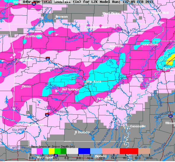
| 12Z NAM Saturday snowfall projections. |
8 AM Saturday Update... I will review all of the 12Z data and have a full update by early afternoon! The 00Z data last night continues with the storm. It looks like it arrives Tuesday night into Wednesday with significant accumulations POSSIBLE... more later.
9 PM Friday Update... Thanks everyone for a fun and huge day on the Arkansas Weather Blog. This system may have been a little teaser to what COULD happen next Wednesday. While there will be a system coming through Sunday and Sunday night, it looks wimpy compared to the mid week storm. So much can and WILL change as the models try to figure it out. There are no guarantees next week, but it still looks promising! One thing you can be sure of.... I'll be here with you EVERY step of the way. We are Your Ticket To BIG Weather Events. More Saturday!
3 PM Friday Update... Everyone wants an update to the storm next week. I really have no changes to tell you, but I will show you a few maps. The models still don't have a grasp on the system and a good handle on the timing. This could come in either Tuesday or Wednesday. Both long term models ( GFS and Euro) both indicate the POTENTIAL for several inches of snow. The Euro puts out almost .6'' of water which would translate to several inches due to the high ratios expected. Generally, the colder the temperatures, the more snow you can get out of water. Read the discussion below as nothing has really changed.
 |
| The 12Z Euro valid next Thursday morning. The surface low is near New Orleans with the 540 line (red dashed line) running through southeast Arkansas. The precipitation would be all snow with a little sleet across the far southeast corner. Winds would be howling out of the northeast causing blowing and drifting of snow. |
 |
| This is the Euro showing 5000 foot moisture levels... very saturated. The -10 degree celsius isotherm is running through NW Arkansas with the 0 degree Celsius line near the far southeast corner. This very, very cold air along with cold surface temperatures would produce high snow ratios. Usually we deal with a 10:1... ten inches of snow for 1 inch of water. This could be 15 to 20:1 if this would verify. I'm just "guess-timating" right now. Right now all the models agree that the air following this snow could be the coldest so far this season, especially if snow is on the ground. The following week looks MUCH, MUCH WARMER! |
MORNING UPDATE... What we are looking at, according to the models, next week is nothing short of fascinating! If you're a weather geek, and you know I am, next week could end up being something talked about for a very long time. When I looked at the GFS long term forecast temperatures, my jaw dropped and my wife couldn't even pick it up. It has a high next Thursday of 21 with a low of 11. Sure that has happened before in Little Rock. It's rare, but it has happened. What makes this incredible is the fact the GFS sees this in the long range. You must understand that the GFS MOS numbers try to trend towards climatology in the long range, which is around 53 for a high and 30 for the low. For these numbers to be cut in half, means it sees it, and there's the POTENTIAL to be colder. I must caution you, this in ONLY one run of the model.
Now to more of the fun and games to deal with next week. The models are showing a fast moving system Sunday night into Monday morning which could bring a light wintry mix to the state. The system is not one which typically gives us significant precipitation.
The system coming in Tuesday and/or Wednesday IS the one to watch and will be followed by VERY COLD ARCTIC AIR. The models disagree how this will evolve, but the Euro and GFS both say this could be a significant storm and it does look like a classic set up for the mid south. I will caution you, being in the long range, you CAN'T look at specifics yet, but the overall picture indicates trouble brewing. The overnight runs of the models showed the northern half of the state targeted, but yesterday it shows all of the state. These are the type of fluctuations I'm talking about.
For those of you sick and tired of this amazing winter, IT WILL get warmer! After next week, there will be no place to go but warmer! Seriously, the cold air intrusions look to stop the following week with much, much warmer weather. Check out the maps below and thanks for reading the Arkansas Weather Blog... We ARE your ticket to BIG weather events!
 | ||
| This is the Euro valid late next Wednesday. It's a classic set up for an "Arkansas Slushy"... snow and ice. The purples and reds NW of Arkansas indicate bitterly cold temperatures at the 5000 foot level. This will translate to another BIG chill here at the surface after the storm passes. |
 |
| The GFSGFS MOS numbers. |


11 comments:
Looking at model data and the MOS numbers I am amazed at what I see for next week. As stated in the previous post, if everything comes together just right, we could be looking at a serious situation with snow and ice.
I will be watching it all weekend long and will post several times on Ninja's Corner.
Enjoy today's snow..and if we get the "big" one next week..get out an play. Make a memory!
Snowtathalon
Here are a few ideas for labeling next week's snow event:
SNOMG (Snow My Gosh)
Southern Snonami
Snoprah
Snozilla
Snoceans 11
Snowly Crap!
Snoverkill
Snowtorious
Or will it just be a:
SNOVEREACTION????
Let's hope its simply,
"THE BIG ONE"!!!
I like the Snowathalon from the first post. Here are some ideas:
Arktic Thunder 2011
Yeti Another Snow
Snornado
Got 2 inches in bull shoals. Considering this isnt a big deal compared to what some of the models are saying for tuesday and wednesday. Were in for a big storm.
I'm a dedicated fan of this weather blog, but I also check other weather sites quite often. What I've noticed, like Todd, Ninja, and others often say, is that sites like accuweather or weather.com, etc. underestimate cold temps (since the models do so too). I often see a posted high that is fifteen or more degrees off just a few days out. With this said, I want to make note that weather.com is already saying a low mid-week next week is 7 degrees for my area. Knowing they are almost ALWAYS too high in there temp. postings, this scares me to think what our actual low may be.
As a teacher, we've missed way too many days already, but if temps. are going to be frigid, I want as close to a foot of snow as I can get to go with it. I would rather stay snuggled up in my warm house than have to go out in that kind of weather!
Thanks weather bloggers for all you do to keep us informed!
Wednesdays Winter Wonderland
Todd
When you say significant accumulations... are we talking another 3 inches or a foot or more??? I know its still a little early but care to venture a guess? My ten year old is flipping out with joy at the thought of BIG snow.
Hello Everyone, I am going to give some thoughts about the 2 possible Winter Weather events,1st Event, I see the possiblity of 1-3 Inches of snow Sun-Mon event for Central & Southern Ark, The main issue with getting these accumulations is surface Temps being above freezing until late Sunday night.2nd The Poss Main Event, I think the state of Ark will see thier coldest Low Temps of this winter season with lows in the single digits for Central & Southern Ark..Alot of this depends on Snow cover & With this event, This time I do think snowcover will be needed to reach single digits,Now for the Main possible Winter Storm, I am going with the same areas I had on this last event, This is for the Mid-week system, I believe this will be a OKC down to Dallas over to Little Rock down to I-20 of Northern La, Overall snow accumulations could range from 3-6 Inches in that area, With areas of the heavy snowfall could see amounts of 6-10 Inches, Right now the areas that is most likley to see the 6-10 Inches of Snow is right along I-30 in Southwestern Ark,No none of this is written in stone,I do think there will be some local spots could see up to a foot of snow!! After next week, It looks like a warm up,but to me, not that dramactic,just back to seasonal normals...I will post some fine tuning around Monday evening...We Shall See...!!??
"One Final note, I know I missed the Little Rock down to I-20 on last weeks event, But this time I dont think the low will pull up until furhter east..What a winter for Central & Southern Ark!!!
I say another winter weather contest pertaining specifically to the midweek system is in order. I need to enhance my chances of winning a weatherblog tee.
This is Wx gurus's wife, My vote is for another attack in the 2nd episode "Flakes of wrath" 2011
Post a Comment