
11PM Sunday Update... This is a tricky forecast later tonight. As temperatures fall, the models show the rain changing to snow after 3 AM. It's going to take awhile to get those surface temperatures down into the low to mid 30s. If we change over to snow, readings around freezing will only promote accumulation on grassy surfaces and elevated object. The models have been keying in on areas from near Conway east and north of I-40 for a little more accumulation. We'll see what happens when the morning rolls around
The mid week system still looks healthy with the highest amounts across western Arkansas. Those amounts will decrease a little the further east you go. I think it's safe to start talking about forecast amounts Monday as we will be within 48 hours. This storm will not be a blizzard as I have explained. It's just a classic set up for snow in Arkansas. Don't get use to this winter weather, a big warm up is still right around the corner.
I'll have more in the AM.
8:15 AM Sunday Update... Meteorologists in this region of the country will earn their pay and then some this week. It's very complicated and active. The reward will be next weekend into next week as the models are already forecasting 50s and 60s for highs and that may be too cool. Let's get through the next few days.
The models are somewhat agreeing on the potential tonight for rain changing to a wintry mix. I have analyzed the data and it suggests that if there's a changeover, it won't happen until after midnight in Little Rock at the earliest and 3 AM at the latest. The temperature near the surface and just above will be too warm. Once it does cool, it will only be close to 32 degrees which means any accumulation will be confined to grassy areas, elevated surfaces, bridges, and overpasses. Once the Monday morning commute starts, the warmth from the traffic and a bump in the temperature into the mid and upper 30s should clear whatever problems exist. I'll be completely honest with you, the system tonight has high bust potential. A swing of a couple of degrees can mean a little more snow. Slightly warmer and it's all rain. The models generally are putting out a dusting to 2'' across much of the southwestern, central, and northeastern areas of the state.
The system Wednesday has some differences with the models now. Everything shows the storm, but amounts are not as heavy as indicated by the data over the past few days. This is why I stressed below NOT to see the models as a forecast right now. The GFS wants to crank out heavy snow across the western half of the state, then it decreases the further east you go. The Euro is a little different and keeps the precip. going further east with .4'' of water for central Arkansas. With the cold air in place, ratios would be high and that could equate to several inches of snow. The GFS on the other hand only shows around 4'' for Little Rock. We have seen more, BUT THIS WILL CHANGE WITH EACH AND EVERY COMPUTER MODEL RUN SO PLEASE DON'T TAKE THESE NUMBERS LITERALLY AS A FORECAST!
Sorry about the all caps! lol. All the models continue to show the massive warm up we have been discussed for several days starting Saturday and Sunday of next weekend.
I will have MUCH more later as the new data comes in.
Thanks for reading the Arkansas Weather Blog... we are your ticket to BIG weather events!
11:30 PM Sunday Update... The GFS came back more aggressive with a wintry mix Sunday night and even gives some accumulations to portions of Arkansas including Little Rock. If anything does fall, temperatures will be right around 32 to 35 so it would only stick to grassy areas. If temperatures go any lower, then there could be problems. The GFS also shows the next storm system diminishing as it moves across Arkansas with the highest totals for western Arkansas. This is exactly what I have been talking about. Don't trust the models whether they say 2'' or 10''. The details will vary until we get closer to the event. Once the models come into good agreement within 48 hours, then we can really get specific. My advice to everyone is NOT to get your hopes up. This has been a much talked about system and expectations are high. We'll just wait and see.
____________________________________________________________________
The next 7 days has the potential to be so wintry, even the biggest snow lover could be begging for mercy and cheering on spring. Here's what we should watch for over the next 7 days:
1. Weak system Sunday night and the potential for light snow
2. Winter storm Tuesday night and Wednesday
3. Coldest air of the season following.
4. Single digits for lows in Little Rock? It's possible and hasn't happened in 15 years.
5. MASSIVE warm up the following week.
I have several maps below to illustrate what the models are saying every step of the way. The weak system Sunday night has the potential to bring light snows to the state, but my concern is with surface temperatures being too warm. While it may snow, any major accumulation may not be possible. A surface low will form to our west and push through the state tomorrow night with readings in the mid 30s. This system is wimpy compared to what the models show Tuesday night and Wednesday.
GFS indicates amounts ranging from 6-10 inches across much of the state. This will NOT be a blizzard since winds will be under that criteria. This is a classic set up for a classic winter storm. Once it exits, cold high pressure sits on us and we have the opportunity to go into the single digits for the first time in 15 years in Little Rock. This will only happen if we have snow on the ground, calm winds, and clear skies.
The major long term models agree on a major pattern change the following week. The ridge of high pressure sticking into Alaska is replaced by troughing in the eastern Pacific. This will help promote a ridge of high pressure across our region which scours out all the arctic air. This will allow temperatures to go well above average. How long will that last? Is this the end of winter 2010-2011? That I can't answer, but there is a light at the end of the tunnel and that light is warm sunshine!
Check out the maps below and check back with us here on the Arkansas Weather Blog... We are your ticket to BIG weather events!
 |
| 12Z Futurecast showing snow amounts Sunday night |
 |
| 12Z NAM showing possible snow amounts Sunday night |
 |
| 12Z Saturday GFS shows a surface low late Wed. in the northern Gulf. It shows heavy snow across much of Arkansas with the back edge moving into eastern OK. Notice the cold high pressure surrounding the storm on the north side bringing in cold air. |
 |
| This is the 12Z CMC indicating heavy snow Wednesday afternoon. The solid black line near the AR and LA border is the freezing line at 5000' The -10 C. line is moving into NW Arkansas. This means whatever falls is frozen. The cold air will promote high snowfall ratios. Meaning it will take less water to produce larger amounts of snow. Not good for snowball making... dry and powdery, especially north. |
 |
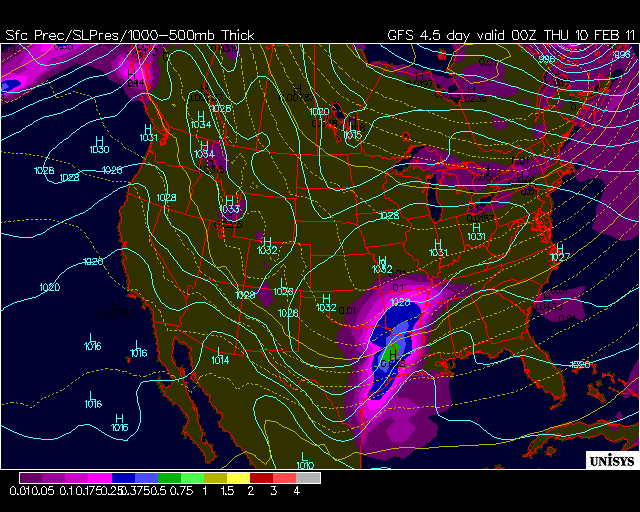
| 12Z GFS shows how much snow could POTENTIALLY fall across the United States over the next 120 hours. |
 |
| 12Z GFS showing POSSIBLE snowfall amounts over the next 120 hours. This WILL likely change. Remember, not a forecast... only a model |
 |
| This is upper air pattern showing troughing in the central U.S. This is our current cold pattern. |
 |
| In 10 days, the upper air pattern shows ridging and MUCH warmer air developing. A pattern change is likely by mid month. |


24 comments:
So glad I moved from Canada to Arkansas to experience this. Brrr!
WOW! Maybe we should call it the "Blizzard of OZ"! Amy said in a previous post "SNOtorious". We should use the complete name - "SNOtorious B.I.G.". Let's keep our fingers crossed. Let's hope it doesn't go too far north, south, east, or west. Let's hope we don't get dry-slotted, warm nosed, moisture starved, low dew pointed, high ground temped or any of those other things that usually happen to out chances of snow! If this happens, I will definitely be ready for the big warm up! If it doesn't happen, I still want one big snow before spring....
Susan in Heber Springs....
Well I havent talked about the weather on Twitter for a week now. I said on Twitter after we missed the BIG storm a week ago"that broke my heart" that I wasnt going to talk about the weather until 1. we went under a Winter Storm Watch or 2. Go under a Tornado Watch....well if the low tracks where it is showing I should be sitting under a Winter Storm Watch by Monday night or Tuesday morning. Ill be happy with anything over 4 inches, and we should get at least that! We have had a total of 4 inches off of 3 different storms up here in Randolph County. I would love one GOOD snow before our pre-Spring begins around the 13th.
Fanatic-
Saw your tweets where you asked about 3 snow events in a week. I looked back at the notebook I kept in the winter of 77-78. It happened twice in January of 78. Man, do I remember that winter. One of the coldest of all time if not the coldest on average. Amazing to me that the coldest temp that winter I show as only 14 degrees,surprisingly, but the Jet stream locked up that year and kept us cold for about 6 or 7 weeks. Anyway the three snow events happened between Jan 9 and Jan 16. Also, Jan 19 through Jan 25.
I'm not saying that is the only winter that has happened, because it may have happened in Feb 2003 and other times, but I don't have record of it.
One correction on my comment above. The first week that we had 3 snow events in 1978 started Jan 11, not Jan 9.
Just for fun my early Sweet Spot is Clinton Arkansas 13.5 inches.
I am really hoping for 1 day of school this week. Tuesday only! Anyway, when do we raise the alarm for the big midweek snowstorm?
Every weather outlet on the web is hitting on this big storm for Tuesday-Thursday. If this happens it will be the biggest in many years. I remeber 1988 and the 14 inches we received in DeWitt. It was amazing thinking back.
Are yall backing off of the storm Wednesday? Just curious bc Todd said in his forecast tonight that the models had disagreements. hope not! Love snow. Love the Blog!
Really hope the GFS is wrong about it diminishing :(
I had a great feeling about this storm The NWS has snow percentages all week though. So maybe it will all pan out and we'll see LOTS of snow :)
The GFS flip-flop that you mentioned on this update is a concern, but you're right to not trust the models, whether it says we get a big snow or hardly any. I'm really trying not to get my hopes up, but it is not easy. :P
Oh well...c'est la vie...que sera sera...You know that old saying "Don't count your snowflakes before they're falling"......
If this run of the GFS verifies then we should definitely go with "SNO-VEREACTION!! Todd, you're making me have a bad feeling about this!!
Okay, so i'm getting excited now. But then I'm done! I just hope this doesn't do like last year where we had rain, snow, rain, snow, all day. We could have ended up with 17inches! I don't want that much snow, but another footer like the one in 88 will do quite nice thank you :) But then hopefully this is our last hurah for the year and we can bring on the thunderstorms :)
I wanna go chase with someone!!
Hey Chad Gardner, wadda you say we get some folks and head down to North hills Country Club for a snowball fight?!
Do y'all think winter wx advisories will be issued today?just curious.
i know the memphis nws said nothing of the kind of the storm fading as it heads east. they say storm will has potential for 4 plus inhes there.Todd i think u are tired of this winter weather seems like you remind us of this huge warmup every post. Im thinking u are tired and wanting some relaxation. Dont worry hang in there a week from now the snow Should be over for the winter.
Thanks Jimmie Lee for the info! I figured that it probably happened during our last 20-30 year cold cycle. I know that you've said to watch out for the next few winters, but what do you think so far about this one? Getting an early start to colder and snowier winters! I wonder if the 77-78 winters had a La Nina influence? It sounds like we were locked into a colder than average pattern, very similar to this winter, which has delayed the typical warm-up for initial La Nina winters.
As for tonight, this is a very dynamic system and I think the NAM is doing a good job. If the heaviest of the precip comes in before sunrise, then yes, the roads could get messy. If that is the case, we should all sleep in and go to work after 10 or so. This is the best case scenario for us snow lovers.
As for Wednesday, I really hope the system slows down and brings the snow in later in the day. While this doesn't appear to be in the cards thus far, accumulation will be greater. If the snow is very heavy, it won't matter-it will stick, but we've seen what happens when temps are around 30-32 with snow falling during the day. So if we get the bulk of the precip falling during the daylight hours, lets hope it's very heavy!!
If we can get the temps to stay in the upper 20's Wednesday, we'll be able to get more accumulation as well. Given these scenarios, it's going to be tough to nail down accumulations, so let's not worry about whether we only get 2 or 10 inches. It does appear the flakes will be flying, so let's enjoy it because this could be the last major event for a while.
I personally think we have at least 1 more system this winter and it could be huge. March will be very active, and we've seen the last few years what can happen as we get closer to spring. This winter won't go out without a fight! I do welcome the warmer weather after this last cold spell. It will be interesting to see if the pattern takes just a temporary break, or becomes more zonal and brings us back to normal. Normal? What is that? Expect the unexpected!
The Weather Fanatic
I really hope this isn't a repeat of march 2008 where i thought I was going to wake up to 4 inches of snow with another 6 during the day. I woke up to rain and ended up with 2 inches that night. Huge disappointed, I don't ever want something like that to happen again and I hope this is big and doesn't bust
The temps keep rising for midweek storm with wed. high of 31 where it was mid 20s yesterday. I was under the impression that it would be plenty cold with cold air in place. Just wandering?
Fanatic-
I think this winter has been a little colder overall than the last winters of this warmer cycle. I think the NWS says a little over 2 degrees for December and 1 degree for January below normal. Before last winter I think we were getting accustomed to milder winters. Snowfall has been totaling more for us last winter and this winter and as we finish this one I believe we will finish in the double digit snowfall total.
Back in the cold winter cycles I used to keep up with the number of days in the winter season that the days failed to reach a high of 40. I would count days in Nov and Mar also to add to the total if any. It was just a way for me to measure and assign my own criteria for a cold winter. 1977-78 had 51 days with highs under 40 as the Jet locked up for a long period of time. I remember the NWS and Tom Bonner relating that event at the time. Most interesting winter with snow on the ground for 5 or 6 weeks. Officially, it wasn't that long. As you know snow acc. or pack is measured only on flat ground in sun,not shade for official depth. But there was snow laying around for at least that long.
Anyway, we have 15 or so days under 40 degree highs so far, and I think that is near average for LR winters. I also used to look at number of days with lows under 20 and snowfall totals for criteria. If we get another 10 days before the end of March with highs under 40, I will consider this an overall colder winter without additional snowfall.
I did a little looking at a 30 year period the other day from the winters of 58-59 to 87-88 and those years averaged 7.55 inches per winter for us. Most of that was in the cold cycle. I love winter history.
snobirdbob you got me good this year. it looks like you are the winner of hour snow contest. i just didnt think the snow would come but it did just lkie you said it would. i owe you some dinners i know and ninja to so far we have got alot of snow in little rock and i never thought we would but it came like you said it would and i owe you some dinners to. i dont think we will se much snow frm tonite or this week i think the models are not correct and it will bust for sure and you will be disapointed for sure and after next week we will see a big warm up. yep we are done with the snow and will have a warm rest of winter and spring. i have been away for a while but now am back. i will try to get you a dinner and ninJa what do you want. it might take me a bit but yu won fair and sqare.
this is hugh.
NLRweatherman dont worry it wont end up like that. The cold air will already be here. I have my thoughts but will wait until our live blog on Tues evening. Make sure u tune in at 7p.m.
Paul The Wxguru
Hello Everyone, I am going to head straight into the Mid-Week system, 1st do I think this will be a record breaking Snow Storm for the Little Rock area, NO! As I stated in a blog post a couple of days ago,I beleive the highest snow totals will be in South & Western Ark, I would say upwards of 10 Inches along the I-30 Corridor from Texarkana up to about Hope & Arkledelphia, Closer to Little Rock area I would say 4-8 Inches will be likely, I wouldnt rule out a foot or more in the Ouachita's Due to higher snowfall-Ratios..One thing I am concerned about or excited about is most of the models are showing the storm losing alot of its moisture as it heads east across Arkansas, I dont think this will be the case, I beleive most people in the state of Ark will see accumulating snowfall..I like the Canadian model of choice, It has handled these situations well in the past, Not only this year but for years,Another thing that could really help snowfall totals is the slowing of the system Wens night, This could really pile up the snow in Southern Ark, areas such as El,Dorado, Camden, Crosset, Montec llia, We could be talking about 5-10 inches of snow for that area, But, This is just a possibility, All in All I beleive the big winner will be the Sweet Spot of the Big Town Of Hope,Ark with 7-10 Inches...We Shall See...:) I sticking with the Triangle Winter Storm OKC down to Dallas over to Little Rock, down to I-20 Of Northern La, In this area is where I think the highest Snowfall totals will be, Hopefully I dont strike out...lol..
Tina, the golf course is the place to be! Lots of sledding going on over at North Hills whenever snow falls.
Post a Comment