Many don't know this, but Erich worked search and rescue in Vilonia Monday night into Tuesday morning. He then chased Tuesday afternoon with very little rest. He's a true asset to all of us!
Isn't it amazing how we went from an extreme drought to this? Mother Nature can be moody to say the least. The front continues to meander around the state with waves of low pressure moving along it. On Saturday night, the National Weather Service office in North Little Rock recorded 2.3 inches in 1 hour and ten minutes. The storms "trained" for awhile with incredible rainfall rates. Roads closed and there were reports homes flooded and some evacuated in western Pulaski county.
Over the past 24 hours ending at 7 AM Sunday morning, check out these incredible rainfall totals:
North Little Rock 5.73''
Little Rock 2.57''
Hot Springs 2.69''
Mount Ida 3.73''
LR Air Force Base 4.10''
West Little Rock 4.92''
We continue to be in a La Nina pattern and this wild weather should not be a surprise. The last strong La Nina was in 2008 when we had a record number of tornadoes (80+) and severe flooding in March of that year.
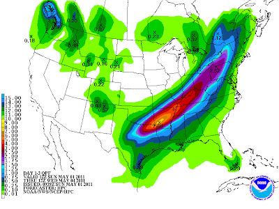
Everyone, it's only going to get worse. Here are the 1-3 day projected rainfall amounts starting at 7 AM Sunday morning through 7 AM Wednesday morning.
 |
| HPC manual progs indicate as much as 7.5'' more could fall along the I-30 corridor into central Arkansas. |
 |
| Slight risk for severe weather today from the SPC |
Get the message out to your friends and neighbors about the flooding. If it covers the road, don't cross it. It's as simple as that.


2 comments:
Todd-
My bucket had 6.5 overnite Saturday, 1.5 during the day Sunday, and 2.2 last night. Total as of 8 am today 10.2. I bet that is a common amount out here in WLR.
Todd-
Final total measured in my bucket starting Saturday night is 11.3 inches. I'm in St.Charles-WLR.
I looked up some info from the NWS at both NLR and LR and noticed something very interesting. Before midnight on Saturday the NLR station had 3.50 inches and at the same time LR had .01 inches. I guess the airport at LR was SE of the track on that particular train of moisture.
Post a Comment