
 FOLLOW ON FACEBOOK: TODD YAKOUBIAN
TWITTER: KATV_WEATHER
Our chance for winter weather continues to exist Monday for much of Arkansas. This will be significant due to the fact we haven't had much winter this season. To put this in perspective, we've had much bigger snowfalls in Arkansas compared to what we're expecting Monday. Whatever falls and sticks to the ground will be gone by Tuesday as highs go well above freezing.
I was talking to the "WeatherNinja" Friday and he brought up a very good point. Arkansas does not see huge winter storms when the surface winds are out of the south or southeast. This usually will push warmer air into the state and change any wintry weather to plain rain. An east to northeast wind is best as it supplies us with a constant feed of cold air. We are expecting southeasterly winds as high pressure slides off to the east. While the precipitation will fall in frozen forms across the state, an eventual changeover to rain should take place from south to north as that relatively warmer air advances at the surface AND aloft. Nevertheless, with cold, dry air in place and moisture moving in Monday morning, we will deal with a period of ice and snow. Evaporative cooling will take temperatures down a few degrees once it starts precipitating, but then readings will finally pop above freezing, barely, by the afternoon. I expect some travel problems, especially on bridges and overpasses. Those problems will last longer across the north.
I will update the blog again later today. Here are a few computer model maps below...
 | |
| By 3 AM, the GFS model indicates snow moving into western Arkansas. Some of this may not reach the ground initially due to dry air. Once the atmosphere saturates, it will make it to the ground. |
 |
| By 6 AM, the precipitation is moving into central Arkansas, however once again, the leading edge may evaporate before reaching the ground due to dry air. This evaporative cooling may actually drop the temperature a few degrees with the onset of precipitation. The red area indicates some sleet mixing in. |
 |
| By noon, the GFS shows the snow confined to portions of central into northern Arkansas. The warmer air moving in from the south is transitioning the snow to sleet, freezing rain, and plain rain. |
 | |
| By midnight, whatever precipitation is left over is mostly rain as temperatures will be above freezing. There could still be a light mix across the north. |
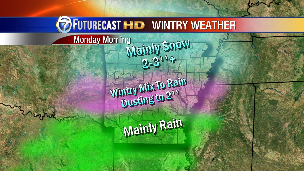 |
| THIS IS VERY PRELIMINARY!!!!! While there could be a little mix across the south, it will change over to rain quickly. For areas from Mena to Little Rock over to W. Memphis, expect snow to transition to sleet/freezing rain, then to rain. Before temperatures warm above freezing there could be a dusting to 2''. Across the north, colder air will stay in place longer which should give those locations higher amounts. |


2 comments:
Two things that I've been looking for that have not happened yet. At LR NWS no high temps below 40 and no lows below 20. Both of these might happen this weekend. A high below 40 almost for sure. I checked and the winter of 1999-2000 was the last winter without a low temp in the teens. That happened even though we had a 7 inch snowfall in January. I'm still looking to find a winter without a high under 40 degrees. Have not found one yet.
As far as the possible winter mix Mon am I could see where we get 3 to 5 inches in LR if the precip starts before 1 or 2 am Monday morning. It could be one of those mornings that it will be very tough for the schools to make their calls on whether to open or not.
Why must there always be horrible warm ups in winter, but in summer no cool downs? Not fair...
Post a Comment