FOLLOW ON FACEBOOK: TODD YAKOUBIAN
TWITTER: KATV_WEATHER
For all of you late filers out there, you may have one eye on your 1040 and another on the sky. A round of rough weather is definitely possible Sunday and Monday.
As a new storm system approaches, strong southerly winds will pump warm and moist air into Arkansas starting Friday into the weekend. Say goodbye to these cool overnight lows! This will set the stage for a round of locally heavy rain and thunderstorms late Sunday into Monday. I'm going to key on the possibility this comes in two stages for Arkansas. I think strong to potentially severe thunderstorms will move into western Arkansas late Sunday, but weaken during the overnight hour. The severe potential will decrease, but still exist. Heavy rain and localized flooding will also be possible. Once the line pushes further to the east Monday morning, southeast Arkansas may destabilize enough to strengthen the storms Monday afternoon. Below are my latest thoughts based on the newest model guidance.
 |
| The GFS late Sunday indicates instability levels high enough to support strong to severe thunderstorms across eastern Oklahoma in to western Arkansas as the front approaches. |
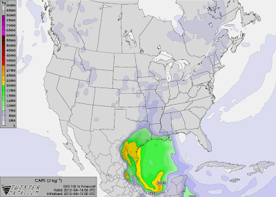 |
| By 1 AM Monday, there's still some instability, but it has decreased. As the line moves into Arkansas overnight, the severe threat will exist, but diminish somewhat. Heavy rain could be an issue at this time. |
 |
By early afternoon Monday, the GFS shows instability levels on the increase once again as the front moves into southeast Arkansas. This is primarily due to solar heating. The heavy rain threat will continue through the duration of the event.
|
 |
| The Storm Prediction Center shows the potential for severe weather late Sunday across eastern OK into western AR |


No comments:
Post a Comment