TWITTER: KATV_WEATHER
As we thought, storms erupted late Sunday afternoon and quickly became severe. While many of us were wishing for the needed rainfall, we didn't want what happened in Hot Springs.
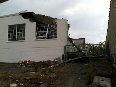
A severe thunderstorm warning was issued for Garland county well in advance. Once it hit Hot Springs, our newsroom phones rang like crazy. Many thought a tornado hit, but it wasn't. This thunderstorm produced a very common phenomena within severe storms called a "microburst". This small scale rush of wind can cause just as much damage as a weak tornado. The National Weather Service office estimates wind speeds around 70-80 mph based on some of the pictures sent to them via email and social media. This is just another classic example of why we urge everyone to be indoors when severe thunderstorm warnings are issued.
The National Weather Service office in Louisville, Kentucky describes the microburst well here...
"In the production of the downburst, that large core of rain and hail that the updraft had been holding in the upper parts of the storm falls rapidly towards the ground. It falls very quickly and drags a lot of air along with it, gaining speed as it plummets earthward. If the air beneath the base of the storm has low relative humidity, the downdraft's speed will increase further as some of the rain entering the dry air evaporates and cools the air, making the air "heavier." Then, if there is also a current of dry air coming into the storm aloft, cooling by evaporation can increase further and the downdraft becomes even stronger.
When the downdraft hits the ground, much like a stream of water coming out of a faucet and hitting the sink, it spreads out rapidly in all directions and becomes known as a downburst. Downburst wind speeds have been known to exceed 100 mph -- as strong as a tornado! Also, from a distance downbursts can sometimes look similar to tornadoes, as seen in the image on the left below. The type of downburst we hear about most often is a "microburst," which means the damaging winds are confined to an area less than two and a half miles across. Otherwise, it's a "macroburst."
 |
| A very large tree was uprooted in Hot Springs by winds estimated around 70-80 mph. |
 |
| Debris littered the roads after the storm |
 |
| Here's a shot from downtown Hot Springs of insulation all over the road. |
 |
| Some structural damage was significant. |
 | ||||
| Debris is wrapped around this tree |


3 comments:
We didn't get pictures but were coming up I-30 from Dallas shortly after this went through. Just before we got to Friendship there was lots of debris on the freeway and trees down along the side of the road. You could tell they had some bad wind with this storm.
Looking at the 7 day forecast, I see 95 degrees for this Saturday and Sunday! Could it be? Could this be a hint at perhaps a more significant cold front that will finally allow us to escape this wretched heat?!
Wait a second, didn't Snowbirdbob say his future predictions would only consist of winter outlooks?
But looking at his Twitter, he is now predicting that a tropical storm will hit Texas or Louisiana landfall.
Post a Comment