FOLLOW ON FACEBOOK: TODD YAKOUBIAN
TWITTER: KATV_WEATHER
Our storm chaser, Michael Hook ( The WeatherNinja) is streaming live from the heart of Isaac.
12:50 PM Thursday update... All seems to be on track right now for rainfall around 2-5'' with isolated higher amounts. The Storm Prediction Center has placed much of Arkansas under a slight risk for tornadoes Friday. Again, these are not your typical springtime tornadoes. They are short lived and usually are on the lower end of the EF scale. Arkansas will be located in the right front quadrant of the storm. The large amounts of shear along with some daytime heating could cause storms to rotate within bands of heavy rain. As I have said, the risk is categorized as slight. The biggest threat is still heavy rainfall.
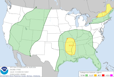 |
| Slight risk for severe weather for most of the state by SPC on Friday |
______________________________________________________________________________
Here he comes! Isaac will slowly inch across the state later today through Friday as a tropical depression, then a remnant low. The biggest threat will be heavy rain and flooding. The threat for brief, isolated, and weak tornadoes will be possible as well. If we do get tornadoes, they usually will not last long and are rated on the low end of the EF scale (EF0 to EF1). On rare occasions, an EF2.
I really have no change to my thinking from Tuesday and Wednesday. The low should track across western Arkansas with the worst weather east of center.
Check out the maps below for more details ....
 |
| The worst impact will be rain, but isolated tornadoes can't be ruled out. Winds will also be a factor, especially with trees affected by the drought. They could easily fall on powerlines so make preparations now if you lose power. |
 |
| The Storm Prediction Center has placed most of central and southeast Arkansas under a slight risk for severe weather. The main threat here will be isolated, brief tornadoes. |
 |
| The hires NAM shows the heavy rain in central Arkansas by late this afternoon. The last to get the rain will be the north and you will be the last to get rid of it. |
 |
By 7AM Friday morning, rain has covered up the state and some of it will be heavy with breezy conditions.
 |
| By 7 PM Friday, look at the hi res NAM showing some convection (storms) across western AR, we'll have to watch these to see if they rotate. |
|
 |
| This map is from the HPC showing the highest rainfall amounts should be across central into SE Arkansas 5-8'' will be possible. The higher amounts will be isolated. |
 |
| Arkansas is not immune to tropical systems. Each line is a track from a tropical system from 1910 to 2010. |


No comments:
Post a Comment