TWITTER: KATV_WEATHER
1:15PM Friday Update... I saw a tweet earlier today that said, "big winter storm possible next weekend?? That's what @KATV_Weather said ;)".
I love our viewers, readers, twitter followers, and facebook followers dearly, but that's not what I said. Once we get much closer to a particular weather event I do forecast on this blog, but the main reason I do this is to show you all the possibilities and the differences in the data we must analyze all the time. During the winter and spring months, our weather gets very active and we must really stay on top of what the data says plus use our own instincts when forecasting.
Remember, I showed you two models and two possibilities. Yes, one did show a snow storm next Thursday into Friday, but guess what, the new run of that model does NOT show it anymore. Does that mean snow lovers have our dreams of more powder dashed? No. The Euro insists on leaving a piece of energy behind, even with the newer run. However, once it pulls out into the central United States, the northern stream of the jet crushes this storm to the south now and fades it away. So it's important to see how the Euro maintains continuity with the cut off low, but has trouble showing where it will go. As is always the case with these closed lows, they are very, very difficult to forecast timing and track. Also, we must remember the other models I have looked at maintain a progressive solution which shows the whole trough moving in with rain and storms followed by dry and cold air.
Bottom line, there's still some disagreement and much can and WILL change. That's why I love looking at the data. It's almost like a weather reality show. Below is the new run of the Euro.
 |
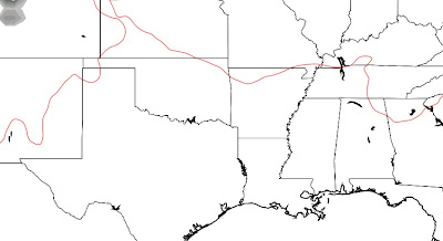
| This is the Euro 500 mb chart valid next Wednesday morning. The vigorous upper level system is located in southern New Mexico. It's that bundle of yellows and oranges. |
 |
| This is valid next Thursday at midnight. See that area of yellow in southeast Texas? That's what is left of the closed off low once it pulls into the central U.S. This is much further south than the previous 2 runs due to the dominance of the northern jet. See those black lines carving out a big "U" over the central and eastern U.S? That's a trough of low pressure and it's very cold and dry here. Still sooooooo much to watch next week! Should be fun! |
_____________________________________________________________________
Yesterday, I discussed the early day run of the European model and how it departed from all the other guidance available... and there's actually so much it can be information overload at times! I try to keep it as simple as possible here. It's the American GFS vs. the European model. Regardless of which one you look at, there will be a frontal passage around the Tuesday/Wednesday time frame. If you believe the GFS, we would have a round of rain and storms followed by dry and cold air. If you believe the Euro, we would have a round of showers, then dry air, then a winter storm by late Thursday. HUGE differences I'll explain further here.
Let's first start out by looking at the track record of these two models this winter. The GFS has done a decent job. If we were grading it, I would give it a "B" so far this winter. The Euro has been outstanding with a grade of "A". Heck, I'll give it an "A+". With that said, at some point it's going to be wrong, but will it be next week? It's like "Johnny Football". At some point he's going to be sacked, but it's rare.
 |
| This is the GFS at 500mb next Wednesday morning. See all those black lines? This is telling you there's a big trough across the central portion of the country. This drives a front through the state followed by cold, dry air. There's a big ridge off the west coast of the United States. See those closed black lines there? This solution is known as a progressive one since it quickly moves the trough from west to east in its entirety. |
|
 |
| Now this is the European model at the same exact time... Wednesday AM. The difference is HUGE!!!! Look at the trough over the central United States. This would drive a front in from the north with some rain, but a very, very minimal severe weather threat compared to the GFS above. The big difference... the Euro leaves a BIG storm behind in the southwestern United States. See that bundle of oranges and reds over southern CA, AZ and Mexico? That's a large and vigorous upper level system. The GFS does NOT have this whatsoever. This storm would eventually pull out to the east, but look what's already happened here. The cold front has moved through delivering a chilly air mass in front of the big storm. |
 |
| Lo and behold, late next Thursday the system pulls out and is located in north Texas with plenty of cold air to work with. If this verifies, and that's a BIG IF, we would have significant wintry weather. |
 |
| This is the Euro valid next Friday at midnight. Look how far south the 32 degree line is located in southern Arkansas. That's the dark blue line. All those greens and blues show you where snow/ice is falling and there's a lot of it here. |
 |
| And here's the GFS at that exact time. NOTHING!!!!!!! That's because it takes the entire system through here Tuesday/Wednesday and does NOT leave a piece behind. |
|
In summary, please remember the blog's purpose is not to make a forecast, but show you what goes on behind the scenes of making one. I hope this shows you how complex our jobs can be at times. Will the European verify? Probably not exactly. Remember what I always say about the long range forecast. DON'T TRUST THE DETAILS!!!! Look at the overall picture. The European tells us a piece of energy is left behind and how that affects our weather isn't exactly known. The GFS says a round of rain and storms followed by cold, dry air. One thing is certain, I'll follow it every step of the way with you right here on the Arkansas Weather Blog. These challenges in forecasting is what makes my job so much fun!


3 comments:
I just had the craziest of thoughts, what if the gfs is right about the severe weather threat but the european model is right about the snow, we get 2 pieces of energy- one with the front, one behind the front after the cold air gets in place- end up with a more reasonable amount of snow because the euro is going insane I would say more on the lines of 2-3 inches of snow widespread, while I wouldn't call this a forecast, it's more a matter of what if
Donny, you bring up an excellent point. Many times neither model is correct and it's something inbetween. We'll see.
It appears that a significant severe weather setup may be unfolding for Tuesday. I'm wondering what Ninja and Todd think about the possibilities on Tuesday, especially if we get the sun out early in the day......
Post a Comment