

1PM Tuesday Update... Good luck on trying to keep up with each model run! Remember this morning I said the Euro said "forgetaboutit" to next Sunday. Well the new run of that model says, "Not So Fast My Friend". The Euro now throws moisture back into the cold air, BUT most of the state according to the data is ABOVE freezing and it's a cold rain. However, as I have said again and again, we must watch this. The computer models don't handle low level arctic air well at all. With that said, I do think there's a greater than 50/50 chance the Ozarks will keep the subfreezing temperatures confined to northwestern Arkansas. Can this change? You bet! Here are the new Euro maps.
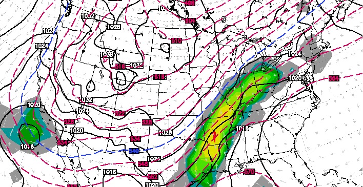 |
| The new Euro valid at midnight Monday shows the arctic front east of AR, but precip is getting thrown back into the cold air. The "540 line" is NW of the state so NO snow here. |
 | ||
| The Euro at that exact same time shows the surface freezing line hung up across the mountains of NW Arkansas. According to this 1 run of this model, that would be an area of concern for ice. Remember, it's wayyyyyyyyyyyyyyy to early to make a call here with the forecast. It's just something we're watching carefully. |
Trying to come up for a title for this blog post was difficult. Using the word "active" is an understatement and using the word "challenge" to describe forecasting it would be as well. Staying on top of it as a meteorologist is not something for the weary. There are so many things going on from the timing of the each system, to how much cold air is in place, to precipitation types, to temperature forecasts, etc. It's enough to wear you out!
Let's start out with what we do know. Wednesday and Thursday... RAIN! and plenty of it! The severe threat will be low and mainly confined to areas south of Arkansas. Rainfall amounts COULD reach 3-5'' or locally more across the southern half of the state. How about breaking a couple daily rainfall records? That's possible. Wednesday, the daily record rainfall is 2.87'' set in 1965 and on Thursday it's 1.82'' set in 1913
It's going to be well ABOVE average temperature wise Thursday, Friday, and a part of Saturday. Record highs? Probably not. Here they are... Thursday 77 (1962), Friday 77 (1995), Saturday 76 (2000). We could get close to 70 these days! I'll watch that mercury for you and see if it happens, but right now, it looks like we'll fall short. However, considering we're looking at heavy rain, near record temperatures, then cold and wintry weather all within 1 week really shows you how crazy this weather will be over the next several days.
Now onto the weekend. A powerful cold front will ease through the state Saturday afternoon with more rain and a few storms. Temperatures will fall drastically compared to where we were during the mid week time period. There are major model differences which continue between the GFS and Euro. Also, each run continues to flip flop within those two sets of data.
Once again, we must watch shallow, arctic air. Here are my thoughts. Like I said Monday, since this will be only a few hundred to a few thousand feet deep, getting it over the Ozarks will delay the real cold stuff from getting here. The latest runs of the GFS continue to show a slow moving boundary with additional waves of moisture into Sunday. The European model shows the boundary moving quite rapidly through the state without any moisture on Sunday. BIG headache for forecasting.
Then there are MORE challenges next week. The European model is indicating an overrunning scenario with very cold air in place while the GFS shows that happening, but well east of Arkansas.
Here are the maps below for the weekend
 |
| The GFS valid next Monday morning at midnight shows additional waves of moisture bringing light precipitation to much of Arkansas. The air deep enough for snow is well northwest of the state. However, we must watch the low level arctic air. The latest sets of data indicates the freezing line will get hung up over the Ozarks and this would just be a cold rain. HOWEVER, it's only Tuesday and this is a model forecast for Sunday! I'm not making a call on this for that reason. A due north or northwest wind at the surface would delay the onset of the very cold air. If those surface winds start to come around to the northeast, then the freezing line would more than likely move south faster. |
 |
| The European model says forgetaboutit! It takes the arctic front WELL east and high pressure builds in Sunday. THIS IS DRY!!!!!!! |
 | ||
| Now onto Tuesday of next week. The front is hung up to the south and east according to the Euro with more energy moving through the region. This results in a big area of overrunning precipitation. The "540 line" is still well north and this is an icing concern. |
 |
| And the GFS for late next Tuesday says, FORGETABOUTIT. This is cold and mostly dry with just some light rain for far southern Arkansas. |


No comments:
Post a Comment