
The 2012-2013 Winter Weather Contest here on the Arkansas Weather Blog will likely go down to the wire. The leader board has changed again with a total snow accumulation between Little Rock, North Little Rock, Harrison, and Hot Springs at 31.3 inches. For the tiebreaker, the total rainfall between Little Rock and North Little Rock this winter season is at 27.32 inches. Right now, Mitzi McCoy is atop the leaders board, but that COULD still change! This will be one of the most interesting endings to a contest we have ever seen on the blog!
This winter will likely end on a wild note. Remember, in the meteorological world, the winter season is defined by the period from Dec. 1st to Feb. 28th. We can always get snow in March and I think this year that's on the table due to the look of the pattern during the first few days of the month. I'm watching several systems over the next 7 days so here we go.
The first one arrives Saturday. This appears to be very minor. At the 500 mb level, the shortwave looks vigorous and I'm a little surprised the computer models are cranking out little if any precipitation with it. This is likely due to the lack of moisture with the system, but I would not be surprised to hear a report or two of snow flurries, sprinkles, or very light sleet especially over western Arkansas Saturday. Again, very minor.
The next system arrives Monday, then another Wednesday. There are differences between all the models of course and I'll show you some of the data below.
 |
| This is the European valid Monday at 6PM. This model has performed very well this winter so we'll use this. This indicates a surface low over NE Arkansas with a trailing front through MS and AL. This would bring a decent round of rain and storms. Look at the moisture getting thrown around the back side of the low in Oklahoma, Kansas, and Missouri. This is the cold side of the storm. Remember, the blue dashed line represents the "540 thickness". Everything to the left of the line is usually snow and to the right liquid. |
 |
| This is "WishCasting". The 00Z run of the Canadian model shows a MAJOR winter storm over northern Arkansas and even the rest of the state would see significant snow as it wraps up the low and intensifies it rapidly. Let's just say right now, THIS HAS VERY LITTLE CHANCE OF VERIFYING. BUT WE CAN DREAM. |
 |
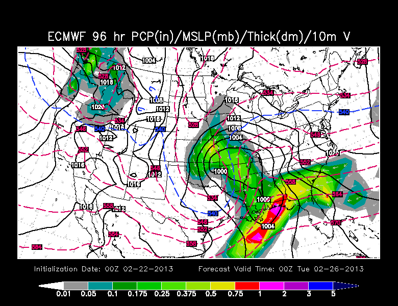
| And back to reality. The Euro sends the surface low (black closed line) up into central Illinois. On the back side, some light snow may fall across northern Arkansas early Tuesday morning. This could change the dynamics of the 2012 2013 winter weather contest. |
 |
| The overnight run of the GFS also indicates a wave of moisture moving in Wednesday. Notice how far south the blue dashed line is! If surface temperatures are cold enough, it could be frozen. |
 |
| This is the European model valid Sunday, March 3rd. I just wanted to show you the huge trough over the central and eastern United States. See the black lines? Look how they make a "U" shape. That's a cold trough keeping temperatures below average. In other words, THE GROUND HOG MAY HAVE GOOFED UP! SPRING IS ON HOLD! |


No comments:
Post a Comment