
First of all, if you get a chance, look at what's happening over New England. I know this is the Arkansas Weather Blog, but that storm is amazing in the meteorological sense. It will be crippling and air travel will be affected as it has a ripple effect across the country.
We have a strong front which will arrive Sunday with a round of rain and storms. While locally heavy rain is the main threat, there could be a strong to severe thunderstorm over southeastern Arkansas. This does not look like any sort of outbreak, but I'll watch it for you.
As discussed yesterday in the video, the front will stall and it should bring a few showers to southern Arkansas Monday. This is where the models are having a difficult time handling the 2nd piece of energy and it's interaction with the front. So this is what we call a "low confidence" forecast. Things will become much clearer later this weekend. The GFS has been very consistent with a round of rain Tuesday and that could change to a little snow as the upper level dynamics moves across the state. The Euro, (my favorite model) has been all over the place from snow to no.
Here are a few maps below. Again, I'll have more later.
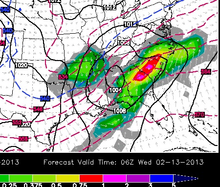 |
| This is the 06Z GFS valid next Tuesday at midnight. Look at that big blob over (official meteorological word. LOL) Arkansas. The blue dashed line is over the south. This is the effect of the upper level energy cooling the temperatures aloft. IF surface temperatures can drop far enough, this could bring a round of rain changing over to a wintry mix late Tuesday into early Wednesday. |
 |
| This is the 00Z run valid late Tuesday afternoon. It shows basically the same thing, but not to the extent as the 06Z run. |
 | ||
| The overnight run of the Euro valid midnight Wednesday indicates the effects of the upper low bringing mixed precip. over the Arklatex. Later frames diminishes the precip. |


No comments:
Post a Comment