
As discussed in previous posts, there will be 3 chances for wintry weather next week. This post will focus on the Sunday system, but first I'll talk a little about the midweek and the late week storms.
On Tuesday, I still think the brunt of the worst winter weather will be across northern Arkansas. This is a set-up for ice. I think it could start as something frozen across the northern half of the state (including central Arkansas), then go to a very cold rain. Again, further north, icing will be a concern most of Tuesday.
A third system will arrive next Friday. This will bring another "mixed bag" of precipitation. As I always say, specifics this far out is useless, but it does appear another round is very possible.
Ok, now onto the Super Bowl Sunday Sleet and Snow. Going to a party? I would really pay attention to the forecast. Roads could be impacted as a mixture of sleet and snow will be possible. Also, I will likely issue a SCHOOL:CON index for Monday as some schools could close. I'll post that on twitter and facebook.
The models keep trending further south with the moisture Sunday afternoon. With that said, I think the best chance for accumulating snow will be from west central into north central Arkansas with sleet along the southern edge of this. That means central Arkansas.
Once again, I'll have more about the Tuesday and Friday system later. There's soooo much on my weather plate so we'll handle each storm one at a time.
I will use maps from weatherbell.com here. It's the 00Z run of the Global Forecasting System (GFS). Remember, it's showing you precip over the past 6 hours. The red line is the 32 degree line. Green is rain, orange is sleet, pink is freezing rain, and blue is snow. This is just a model and details will need to be adjusted as we get closer to the event.
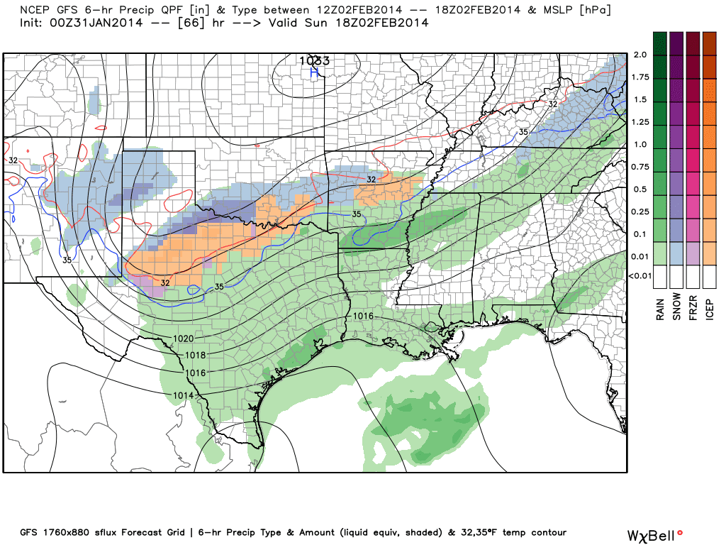 |
| By noon Sunday, the precipitation is breaking out. However, the freezing line is further north with temperatures around central Arkansas barely above freezing. This shows you the amount of precip from 6AM to Noon Sunday. Rain south, sleet and snow central and north. See the "H" near Kansas City? That's a surface high from Canada and our cold air pump. The isobars (black lines) are oriented in a way which brings in an easterly flow at the surface. This is favorable for wintry weather. |
 |
| By 6PM, the surface low is shaping up well south of the state and we're firmly entrenched in the cold air sector. It looks like sleet for much of central AR and snow further north. |
 |
| Between 6PM and midnight, freezing rain, sleet, and snow is affecting much of the state with the back edge coming into western Arkansas. |


3 comments:
Haha. love the title. And I'm sure mother nature will call an audible at the last second and mix things up.
Todd,
Please explain. Climate Predication Center has shifted Northern Arkansas from Freezing Rain to Heavy Snow on Tuesday. NWS in Little is maintaining the freezing rain forecast. I know it is all about temps. Computer models are still shifting. Probably Sun before they get a good handle on Tues.
We are praying Mountain Home just gets sleet, e do not need the ICE
Post a Comment