
You will not hear me say this often, but the Global Forecasting System (GFS) has done a remarkable job over the past few months and this week is no exception. Last Sunday, most of the data suggested a round of storms Thursday, but differed on the details for Friday. The European and Canadian were more progressive moving the front out of the state quickly thus making Friday a beautiful day. However, the GFS insisted the front would stall across Arkansas with another wave of low pressure developing on the front keeping rain/storm chances in the forecast Friday. Now all the data sees the GFS idea.
I'm expecting 3 rounds of rain and storms through Friday. The first arrives Wednesday night. This will not be severe. Behind this round, the airmass will become warmer and more moist as strong southerly winds develop Thursday. I expect winds around 20-30 mph and gusts could reach 40 mph. The next wave will develop west of us and push a front into the state late Thursday. At this time, I expect storm to develop just west of Arkansas and push into the state late Thursday afternoon and evening. They should weaken as instability decreases at night. The front will ease into the state and stall as another wave of low pressure develops along the front west of Arkansas again. This will bring yet another round of rain/storms Friday afternoon and evening.
Here's the good news. Despite a few morning clouds Saturday, this weekend could be AWESOME! About a week ago, I sent out a tweet indicating the first week of April could bring a significant storm system. Climatology and the data suggests we would have the potential for some rough weather and I think that's looking more and more like a likely scenario by the middle of next week. Well, we went from winter to spring in a hurry huh?
 |
| This is the weather map valid late Thursday. See that front edging into NW Arkansas? I expect rain and storms to develop along and ahead. This will bring a slight risk for severe weather later Thursday into Thursday night. The primary risk will be wind and hail. As the sun sets, the instability will decrease and storms will weaken. |
 |
| By Friday morning, the front is in southern and eastern Arkansas. See that next wave over north Texas. That will push the front back to the north a little and another round of thunderstorms can be expected late Friday. Some of those could be severe with hail and wind the primary threats. |
 |
| The Storm Prediction Center has placed much of Arkansas in a "Slight risk" for severe weather both days. |
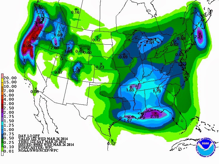 |
| Rainfall amounts through Saturday could range around 1-2 inches. |


No comments:
Post a Comment