
It was almost a week ago I said the pattern we were going into would become very active. I think it has lived up to those expectations. We have had large hail, damaging winds, a couple tornadoes, heavy rainfall, and the most photogenic mammatus clouds I have ever seen in Arkansas. For those of you who don't think weathermen are immune to what mother nature throws our way, think again. I have no electricity. I'm one of about 15 thousand without it this late Saturday. With more storms in the forecast, I imagine many more will be in the same boat I'm in right now.
Now onto the next system scheduled to arrive Sunday. Another disturbance will roll through the state and there will be yet another risk for severe weather. Wind and hail will be the main threats and now we must really pay attention to flooding possibilities as many areas are soaked, especially northern Arkansas. I think the coverage will only increase Monday into Monday night as a stronger wave pushes into the region. I do see some light at the end of the tunnel. Rain chances will go down later next week, but temperatures and humidity levels will be high. Some of these hi res model maps are from weatherbell.com
 |
| Hi res simulated radar from the HRRR Sunday morning at 7AM. Do you see the comma in SW Oklahoma? That's the small area of low pressure and the storms/rain wrapping around it. You can see it's set up like a warm front with storms extending east of it into southern Arkansas and a cold front extending south into north Texas. This system will eventually make its way into Arkansas with another round of storms. |
 |
| By 9AM, storms are possible over southern Arkansas with the low moving into south central OK. Will this nail the forecast? I have doubts it will be exactly correct. While I love this short range model, it missed the timing of the storms Friday by a few hours. |
 |
| The Storm Prediction Center has central and southern Arkansas under a slight risk for severe weather Sunday. The main threats will be wind and hail. |
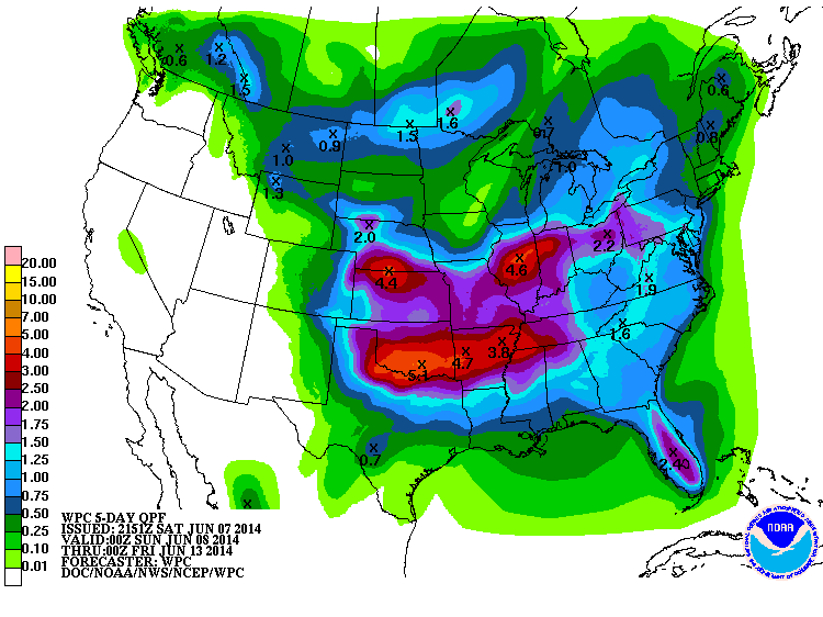 |
| Rain over the next few days could range from 2-5'' according to the Weather Prediction Center. |
 |
| By Tuesday, it appears the system may wrap up further and finally push the cold front into the state and out by Wednesday. This would decrease our rain chances by the middle to end of next week. Until then, more rounds are expected and it could be more widespread and heavier than what we have seen over the past few days. Stay tuned. |


No comments:
Post a Comment