It was just 34 years ago this month (1980), we had the hottest July and the hottest month ever in Little Rock weather history. We know how blazing hot this month and the entire summer can be! An unusual amplification of the jet stream will send a blast of cool air south this week with a couple waves of rainfall. I expect showers and storms to accompany the surge of cool air late Monday into early Tuesday, then another round of rain late Wednesday, Thursday, and even into Friday. The round at the end of the week will be very interesting to watch for a number of reasons. The front will be stalled to the south of the state with waves of energy bringing rain behind the boundary. This overrunning pattern is typical of fall and winter, NOT SUMMER! If this all comes together, it has the potential to keep daytime highs very cool due to the clouds and rain around. There's also the potential for heavy rainfall, especially across southern Arkansas so rainfall records will have to be watched.
Amazing! We're usually kicking back and relaxing this time of the year sounding like a broken record, "Partly cloudy and hot with a slight chance for isolated afternoon showers and storms". Not in 2014! With each day that passes and with each drop of rainfall, the chance for hitting 100 degrees decreases. While we still have August to contend with, it will be fun to watch. The last summer without a 100 degree day was 2009. There have been 54 summers since 1880 without a 100 degree temperature recorded.
Here are just a few of the records to watch this week.
Rainfall...
- The daily record rainfall Monday is 1.66'' set back in 1963. With a few late day and evening storms possible, if one moves over the airport where the official records are kept, this could be challenged.
- While the heaviest rainfall will likely stay across southern Arkansas later this week, any northward shift will have to be watched. The daily rainfall record Thursday is 3.77 inches set in 1923 and the daily record on Friday is 1.25'' set in 1888.
- Little Rock is 4.4 inches of rainfall away from breaking into the top 10 wettest July's on record. So far this month, we have had 3.36'' and some of the data says we could add at least 2 inches this week alone. With a couple more weeks to go in July, this record will need to be watched.
Temperatures...
- Some of the data says Little Rock may drop into the upper 50s for lows, especially Wednesday morning. The coldest July temperature is 54 degrees on July 7th, 1972 and the 10th coldest July temperature is 58 set on July 15th, 1967. It's possible to jump into the top 10.
- The coolest July high temperature is 69 degrees in 1891. 73 degrees has occurred 8 times throughout history to tie for 3rd place. With clouds and rain around Thursday and MAYBE Friday, it's within the realm of possibilities, especially if the focus of the heaviest rain shifts north.
- The daily record low Wednesday morning is 59 degrees set in 1990. That could be broken.
- The daily record low Thursday is 62 degrees set in 1945. That could be challenged.
- The daily record low Friday is 62 degrees set in 1976, 1967, and 1894. That could be challenged.
Some of the model maps below are courtesy of weatherbell.com.
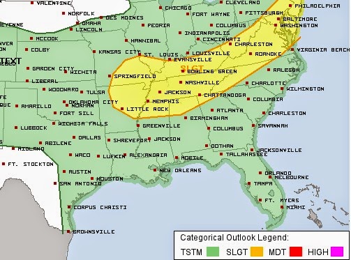 |
| The Storm Prediction Center has placed much of central, northern, and eastern Arkansas in a slight risk for severe weather later Monday into early Tuesday morning. The main risk will be wind and hail. |
 |
| The GFS from weatherbell.com has temperatures just off the surface in the upper 40s over the Ozarks Wednesday morning with record breaking cold across central Arkansas. Remember, if we drop below 59 degrees on this morning, it will be a daily record low and break into the top 10 coolest July temperatures on record. |
 |
| With a round of rain moving in Thursday, these are projected high temperatures just off the surface. This would be record breaking too if this actually verifies. It would be the coolest daytime high on record for the entire month. I'm not willing to buy this at this time and our official forecast is in the mid and upper 70s, but may have to be taken down a bit. |
 |
| Friday could be record breaking too. These are projected high temperatures Friday from the GFS. Lower 70s!!!! Again, I'm going a little warmer than this with our official forecast. No matter how you look at it, it's WELL BELOW AVERAGE. |
 |
| The WPC projected rainfall over the next 7 days brings more than 4 inches to southern Arkansas. Rainfall records will be challenged. |


No comments:
Post a Comment