River flooding will become an issue this week and beyond. As far as severe weather is concerned, there will be a very low threat south and west later Tuesday. It would not surprise me to see a couple strong to maybe severe storms, but again that threat is low.
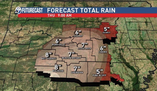
How much rain and where? If you read my previous blog posts, you know that's something we have been trying to pin down. The axis of heaviest rainfall should be located across western and central Arkansas or roughly the western half of the state. I think amounts of 5-7'' through Saturday will be a good bet with isolated higher amounts. The further east you live, the amounts should decrease with a sharp rainfall total gradient setting up over that portion of the state. That simply means there will be a short distance between high rainfall totals and lower amounts.
Once again, I want to discuss the "what ifs". With a well advertised storm system like this seen on the models well in advance, you have to always think of what could go wrong with your forecast. The exact location of the heaviest rainfall could be misplaced a bit, but probably not by much. Also, something I have talked about since last week. If a big cluster of thunderstorms develops along the Gulf coast or Louisiana, this can rob moisture from advancing north and decrease rain totals significantly. While that scenario is possible, at this point, it's unlikely to happen. Remember, it's something I'll be watching as the event unfolds.
I have had some tell me the word "biblical" rains are coming. I do not know where that is coming from and I never said that. If this event seems "hyped" it's only because the models have seen this for many days and I have tried to stay on top of it as much as possible. My goal is not to hype, but communicate the threats effectively. My goal is to pin down this forecast to the best of my ability. This will be a significant rain event, but this is not going to be something we have not seen before in the past. We get heavy rain events this time of year!
Here are daily rainfall records for Little Rock. Some of these might be challenged.
- Tuesday March 8th, 1.97'' set in 1990
- Wednesday March 9th, 4.32'' set in 1878
- Thursday March 10th, 2.02'' set in 1903
- Friday March 11th, 2.68'' set in 1921
 |
| The GFS through Thursday morning shows significant rainfall for much of the metro with higher amounts southwest and lesser amounts east. |
 |
| As of Tuesday morning, a flash flood watch is in effect for most of the Channel 7 viewing area. |
 |
| This is our updated Tuesday morning rainfall forecast Tuesday through Saturday. I do think there could be amounts over western and southwestern Arkansas between 7 and 10'' over a 4 day period. |


4 comments:
Well done sir!
Andy COunts
Hey Todd, Excellent Post! I wish I had known about these "biblical" rains earlier so I could have had my ark ready but I've heard I can dog paddle pretty well. This is just people not remembering we have heavy rain in the Spring in Arkansas every year. A near "biblical" one was the Clinton disaster on December 2nd-3rd 1982. You've got a post from 2012 on the blog about it and yes it was during a strong El-Nino year. The one question I've got that I've been researching and I can't find an answer to is has there been so many significant large rain/flooding events in a large El Nino like this? Starting 365 days ago to now there has been the flooding from May 8th through the 11th 2015. Then there was the December 27th-28th, 2015 flooding event which was also epic. Now this one may drop totals similar to the past 2 events. The big plus about this event, the ground is drier prior to the past 2 major events, the minus is that trees and plants are still mostly dormant so it could be interesting but nothing Noah would gathering the animals for. Thanks for your time!
Todd, I live in Brinkley and a few months ago I purchased a Ambient Weather Observer model WS 10001 WiFi and erected it on a pole in my back yard. I found it to be very reliable. I am connected to the Weather Underground under the Brinkley location at West Cloverdale Dr. If you could use any of my Brinkley information feel free to use it. We have received 2.2 inches up to midnight last night and another .24 as of 10:45 AM today. Enjoy Channel 7's weather and your comments.
Hey Todd, Before people start saying this rain is the direct result of global warming and all that I've got part of the research complete to the question I asked you above. This current rainfall event surprised me at how similar it is to the rainfall event of April 24-26th of 1966. Looking at the old weather charts from the NOAA Central Library and also comparing to make sure that at least the beginning of 1966 was an El Nino year from the Climate Prediction Center and the comparisons were amazing. There was an abnormally strong/cut off low over Mexico, stalled front over Arkansas, and the heaviest rain was over the central, southern, and eastern parts of the state. By the 26th it was showing the low opening up over us just as the models today are showing for this system. Also of interest, on April 30th, 1966, the Ouachita River crested at Camden at 39 feet. So far, forecast crest for this system is 33 feet and perhaps rising more, only time and rain will tell. Thought you might enjoy history repeating itself. Thank you for your time!
Post a Comment