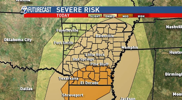
I was very hesitant about storms late Friday in the Channel 7 viewing area. As it turned out, most of the activity was in eastern OK, far NW Arkansas, and southern Missouri. That's where I think it will stay until later today. The "main event" should arrive late today into tonight from west to east. However, the HRRR is trying to blow up storms over the state this afternoon. With that said, my favorite short range model, (HRRR), is really struggling lately. It was completely wrong with storm development Friday PM. I will watch for any development this afternoon because you can't completely ignore what it says. However, I still think the worst will arrive this evening into tonight. The main threat will be flooding rainfall, large hail, and damaging winds. Could there be a tornado or two? Yes. I expect a tornado watch to be issued later Saturday. The highest chance for flooding rainfall will be across northern Arkansas where totals will be around 6'' or more.
The HRRR is from Weatherbell.com
 |
| The HRRR at 7PM. These "future radars" are never perfect, but it does show you where the heavy rain and storms will likely be located. |
 |
| 9PM HRRR |
 |
| 11PM HRRR |
 |
| 1AM Sunday HRRR |
 |
| As of Saturday morning, most of the state has an "enhanced risk" for severe storms. |
 |
| Severe weather impact for the Channel 7 viewing area. |
 |
| Euro total rainfall. |


