The newest data this afternoon (Tuesday June 20th) continues to indicate Cindy will have an impact on Arkansas. The main threat will be heavy rainfall starting Thursday and ending late Friday. If the data continues to stay consistent, I would expect a flash flood watch to be issued for much of the SE 1/2 of the state including the metro.
There will be some who get rain and others who will get little if any. It's northern Arkansas who will see the least as it appears today.
Whenever you have a landfalling tropical system, you also have to be concerned about isolated, brief, and weak tornadoes.
 |
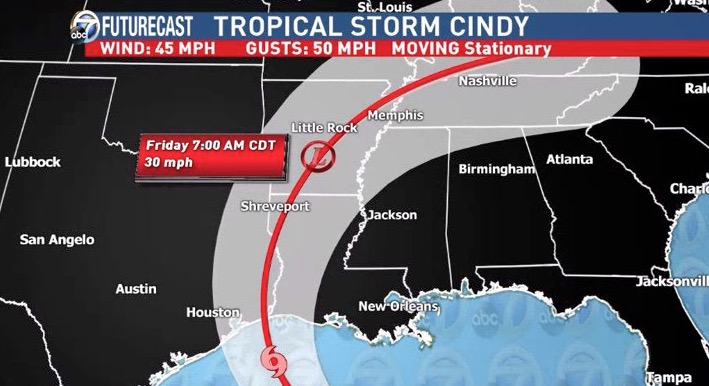
| The Tuesday early afternoon forecast track continues to shift the landfall further west and there's still potential for it to move more to the west. This continues to look like a favored track to have impacts on Arkansas Weather. I would not be surprised if the track through Arkansas (red line) shifts a bit further to the northwest. It's along and east of the track that must watch out for heavy rainfall and an isolated tornado or two. By the time it gets to the state, it will be a depression at most. Some gusty winds will be possible though. |
 |
| Every computer model run will look different, but this is the morning run of the GFS. Notice the large swath of heavy rainfall right along the I-30 to 67/167 corridor with low amounts northwest. Remember, this is guidance and NOT a forecast. However, it does line up well with the expected track. |
 |
| The RPM only goes out through midday Friday, but 2-3'' amounts could be common in many areas according to this model. Don't take these exact amounts literally. Only pay attention to the area of heaviest rainfall. |
 |
| The NAM shows a corridor of heavy rainfall through western Arkansas and is different than other models. This is especially problematic if this verifies due to the terrain and runoff in western Arkansas. This still shows a strong gradient between the "haves" and the "have nots". Northwest Arkansas doesn't get much from this model either. Remember, don't look at the exact amounts and take it literally. This is not a forecast. It's guidance. |
 |
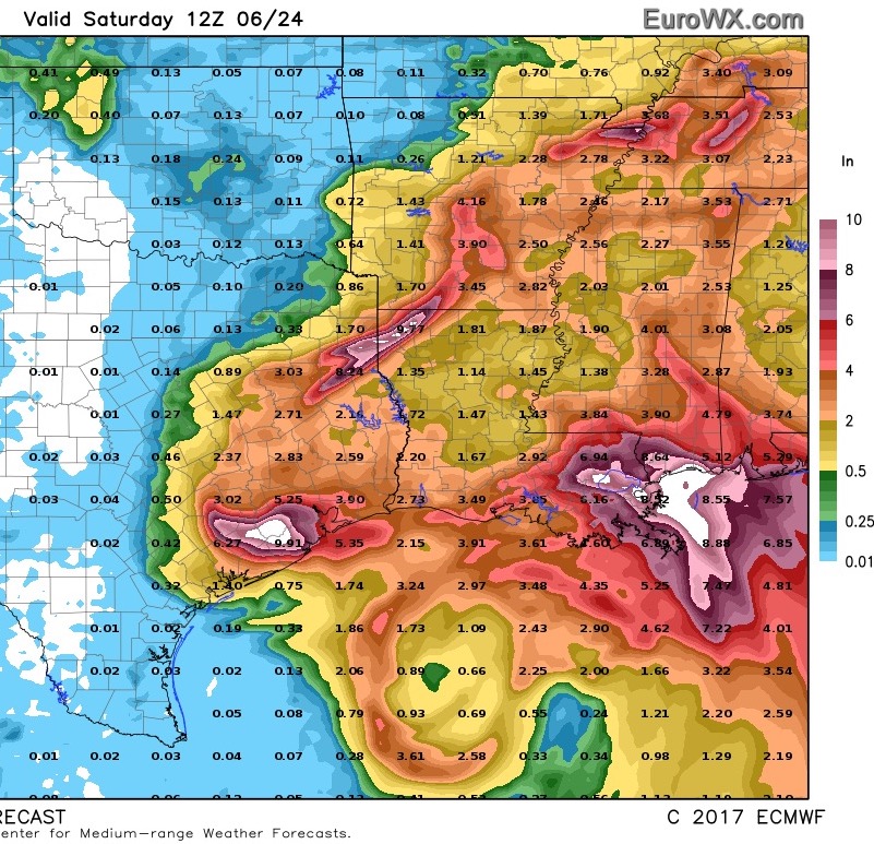
| The European computer model shows the SE 1/2 of the state including the metro for the heaviest rainfall. This has been remarkably consistent. |
 |
| Main impacts along and east of the track. These impacts are subject to change depending upon the exact track of Cindy. |


No comments:
Post a Comment