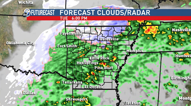
I still expect a cold rain for much of central and southern Arkansas with embedded thunderstorms producing small hail. This is a fairly dynamic system. This should all get underway mid to late afternoon and will be gone by sunrise Wednesday. I expect school closings across northern Arkansas, but there should be melting by Wednesday afternoon.
A winter weather advisory is in effect for much of northern Arkansas across the areas I have been outlining. Some of you may remember "freezing rain advisories." Those are no longer issued by the National Weather Service. It's now a winter weather advisory for freezing rain.
Why not an ice storm warning? Amounts must be .25'' or higher to meet the criteria for an ice storm warning. At that threshold, we start to see significant issues with electricity going out. There could be a small area across north central Arkansas where the amounts do exceed .25'', but not by much.
I asked Entergy yesterday what they were doing to prepare. Here is their response.
"We are making sure all our trucks and crews are properly outfitted for any potential weather events. We are monitoring the weather closely. Proactively, we trimmed limbs away from more than 7000 miles of power lines 2017 along with other storm hardening work."
I don't expect a major storm with widespread outages, but there could be a few and it sounds like Entergy has taken a very proactive approach in recent months and are ready. Again, I don't expect widespread outages, but if the power does go out at your place, it's a big deal. I understand.
 |
| A winter weather advisory is in effect for the areas the models agree on. |
 |
| Subject to change... the school:con |
 |
| I'm using the HRRR run this morning and it only goes out to 8PM tonight. By 1PM, scattered showers are developing. Maybe light frozen way north. |
 |
| By 4PM, the the winter weather advisory is in effect and we're getting wintry weather north. Look at the pockets of red south. Those will be thunderstorms capable of producing small hail. |
 |
| By 6PM, the wintry mix is well established north with rain and thunderstorms elsewhere. |
 |
| By 8PM, it's still going. I expect the mess to be out of here before sunrise Wednesday. |
 |
| There's a low threat for strong to severe thunderstorms central, east, and south. Again, the main threat will be small hail. |


No comments:
Post a Comment