FOLLOW ON FACEBOOK: TODD YAKOUBIAN
TWITTER: KATV_WEATHER
As defined by my Yakoubian-Webster dictionary:
Normal- Not Arkansas
There's never anything normal about it. You know that! I really think the National Weather Service should stop using the word completely and substitute with "average". It gives a false impression that there is a normal and anyone living in Arkansas knows how it can swing from one extreme to another. For example, the winter of 2010-2011 was very, very cold and this past one was quite mild. If you combine the two, you might find temperatures were "Normal" between the two. I don't think anyone would call it that so why not just use the word, "average"?
Anyway, that's not the purpose of this post. For the past several weeks, temperatures have been unseasonably mild and record breaking. We have almost lost site of what "average" for this time of the year really is. There's a CHANCE we could get closer to it soon. If you're wondering what the "average" is this time of year, we should have highs around 70 with lows near 50.
After the unsettled weather late Tuesday into Wednesday, temperatures will warm back up. Next week, the pattern shows signs of changing which could bring us back to reality.
Check out the maps below for an explanation.
 |
| The Monday run of the European model at 500 mb shows the pattern amplifying and changing. Look at the black lines. See the ridge across the western United States? This will allow a trough to dig downstream and dump cooler air into the central and eastern United States by next Monday and Tuesday. All the warm air will move to under the ridge across the western United States. By this time next week, we may be singing, "Ding Dong The Ridge is Dead". |
 |
| The European surface map valid next Tuesday shows a front well south of Arkansas and an area of Canadian high pressure moving into the Dakotas. The circulation around that high and the low to the east will drive cooler air into our neck of the woods according to this model. |
 |
| The American GFS is very similar showing the pattern amplifying at 500 mb next Tuesday morning. Look at the black lines again. There's ridging across the west and troughing across the central and east. COOLER AIR! |
 |
| The GFS at the surface shows the front and the wet weather associated with it south of Arkansas next Tuesday morning. There's that area of high pressure coming out of Canada and it's located across the Dakota's. Nice model agreement!!!!!! |
 |
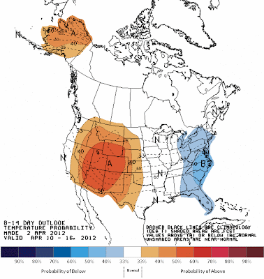
| NOAA's 8-14 day outlook really shows the ridge and trough set up! Look at the area where above average temperatures are more likely... the western United States. That's underneath the ridge. The east should have cooler than average temperatures. Arkansas is between the two. If the models verify, I think we'll have highs in the 60s and 70s with lows in the 40s and 50s. It's too early to get excited about this, but let's watch it. Since it's in the long range, it could change, but there is model agreement! |


2 comments:
Todd, what you are talking about for next week is "average" for Arkansas. Almost always, Arkansas experiences a "cool" week either before or after Easter. After that cooldown, temperatures tend to shoot up and never come back down. We will see if that is indeed what happens.
Almost always, you say? Last year our heat wave didn't start until the end of May. Temperatures steadily climbed from the upper 70's to the lower 90's. A nightmarish 7 day forecast indeed. Then began our brutal summer.
Post a Comment