 FOLLOW ON FACEBOOK: TODD YAKOUBIAN
TWITTER: KATV_WEATHER
FOLLOW ON FACEBOOK: TODD YAKOUBIAN
TWITTER: KATV_WEATHER
7:30 PM Wednesday Update... I really have no change to my thinking in this post below and previous posts. Getting remnant tropical systems in Arkansas isn't rare at all. They are usually big rain makers and I think that will be the BIG story with Isaac. Once again, isolated and brief tornadoes will be possible. I fully expect thousands to lose electricity for the obvious reasons, but it might be a little worse due to weakened trees from the drought. As mentioned below, the track of the center is CRUCIAL. The right front quadrant is the most likely area to see the worst weather. Check out this updated map below.
 |
| This is the late Wednesday QPF map update from HPC. The track they are going with here is obvious. Do you see the tremendous gradient in the rainfall amount to the west? It's along this gradient the low is expected to track. The heaviest amounts of rain will be right of it and it could add up to 5'' or even more. Some places could see up to 8'' according to this. As always, we'll keep you updated on Channel 7. |
|
|
_____________________________________________________________________
10AM Wednesday Update... The NAM scenario...
I think the latest version of the consistent North American Model has merit. It's simply the solution which is more west than others including the official track. If the NAM verifies, the center will ride up into northeastern Texas and eastern Oklahoma. The heaviest rain would fall just east of the centers track. The QPF fields show a swath of very heavy rain across western Arkansas with a very, very sharp gradient over central areas. Will the NAM verify? Tough to say right now, but it is within the realm of possibilities. This solution makes sense though as the storm is steered around the periphery of an upper level high located to the north. Check out the map below...
 |
| This is the total precipitation according to the Wednesday morning run of the NAM. The center tracks just west of the state with a swath of 3-6'' of rain for western Arkansas. Notice the sharp gradient east. This solution is just west of the official track from the National Hurricane Center. For all that, check out the blog post below from this morning. |
|
|
_____________________________________________________________________
The exact track of the center is low pressure is crucial once Isaac pulls away from the coast and moves into Arkansas. I know I have said this several times and I'm sorry for boring you with it, but this is just meteorology 101. The worst weather is east of center in what's called the "right front quadrant". For several days now the models have trended west with that track from Florida to Oklahoma. What's a 1000 miles anyway when forecasting? LOL.
While areas west of the center will get rain, the east side is exposed to 2 things that concern me: flooding rainfall and tornadoes. So knowing where that tracks helps us better warn you! Remember, these are NOT your typical springtime tornadoes. They develop quickly and end just as fast. They are also on the lower end of the EF scale. However, I have seen them on rare occasion reach EF2. The last time we had a tropical system affect Arkansas was 2008 when Hurricane Ike brought 7 tornadoes.
I have a ton of maps to show you everything from similar past tracks to the latest data with Isaac. Don't forget to download our KATV weather app for iphone and droid. Also, sign up for weathercall 7!
 |
| This is the official forecast track from NHC showing the center going through western AR. I have seen models that take it farther to the west and I'll show that below. Remember, east of center is the worry and that's much of Arkansas. |
 |
| This is the expected rainfall projection from HPC. Notice several inches could fall EAST of center while areas to the west will get some rain, just not as much. Any change in the track will change where the heaviest rain sets up. |
 |
| Here is the latest version of the Global Forecasting System showing the highest amount of rain covering much of Arkansas while the center of the low moves up western Arkansas late Thursday into Friday. |
 |
| The GFS early Friday morning.... The low is on the OK/AR state line near Mena. This exposes all of Arkansas to flooding rainfall and the risk for isolated tornadoes. |
 |
| The NAM is an outlier model. The low is weaker and near Dallas! While this solution is unlikely, the highest threat would be southwest AR into west central areas closer to the lows track. |
 |
| The UKMET shows the center a bit east of the official track with it over central AR early Friday morning. Look at all the heavy rain! |
 |
| The European model shows the center in northern LA late Thursday. This would bring a heavy rain to much of central and eastern AR along with a threat for tornadoes. |
 |
| The National Weather Service has issued a flash flood watch for much of Arkansas accounting for the "official" track. Several inches of rain would be possible. Our ground is so dry that much can be absorbed, however, heavy rainfall can run off and cause flash flooding. Remember, turn around, don't drown. |
 |
| The Storm Prediction Center has placed far southern Arkansas under a slight risk for tornadoes Thursday. |
 |
| For Friday, the SPC shows an area of 5% probability for severe weather over much of Arkansas. The main threat will be brief, isolated tornadoes. |
 |
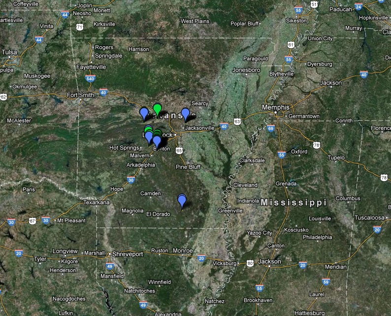
| Courtesy of the National Weather Service Little Rock... A few days later, Ike brought heavy rainfall and seven tornadoes to the state. The path looks familiar huh? Again, east of center is not a good place to be! |
 |
| Each marker represents a tornado touchdown from Ike. Again all east of center. |

 FOLLOW ON FACEBOOK: TODD YAKOUBIAN


No comments:
Post a Comment