TWITTER: KATV_WEATHER
11:50 AM Thursday morning update... This video will go over hi resolution model data for tonight and Friday morning. Here are the key points to this: anything that falls will be light, gone rapidly Friday morning, and mainly target northern Arkansas. Watch the video for more in-depth analysis.
Remember, when you step outside today, the computer models said it would be 70 degrees today on its runs earlier this week. I'll address that and how it pertains to next week further down this post.
Remember, when you step outside today, the computer models said it would be 70 degrees today on its runs earlier this week. I'll address that and how it pertains to next week further down this post.
The key to this forecast is the word "LIGHT". I still don't think this will turn out to be anything like the Christmas storm as amounts will only reach .01-.1'' across much of central and northern Arkansas. This WILL be enough to cause slick spots on the roads.
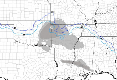
Temperatures will fall today under mostly cloudy skies and northeasterly winds. This is setting the stage for a weak disturbance tonight to bring areas of light freezing rain and drizzle. It's very important to note that whatever light accumulations do occur, will melt rapidly Friday morning as temperatures go well above freezing. The target area continues to be northern and MAYBE some portions of central Arkansas. As mentioned in the previous post, we must watch to see how far south the subfreezing air penetrates. Also, we'll watch the dewpoints. A significant difference between this and the surface temperature could lead to greater evaporational cooling. This lowers temperatures even further than what the computer model guidance suggests once the light precipitation begins.
I'm going to use the Euro maps below since this computer model has shown remarkable consistency. However, please note, other models do show the freezing line further south...the NAM.
 |
| This only moves a little by 6AM Friday and stays across northern AR with areas of light freezing rain and sleet up there. |


No comments:
Post a Comment