SCROLL DOWN TO THE PREVIOUS BLOG POST FOR THE WINTER WEATHER CONTEST.
12:45 PM Wednesday update... I just looked over the newest data from the GFS and it appears the chance for brief, light icing is possible Monday morning. This isn't the type you spread on top of a cake either. The atmospheric conditions will not be favorable to any snow at this time. Whatever falls will be light and should turn to a plain, cold rain around mid morning according to the data. Remember though, it doesn't take much ice to cause a couple slick spots. This is Wednesday and the scenario will likely change a little.
 |
| I gotta show you the Euro. Here's the total precip from midnight to 6AM. The blue dashed line is well north so this isn't snow. |
 |
| Now here's the surface temperature at 6AM. Notice the white line (32 degrees) is located over western AR and near the MO border. This implies any light icing would be confined to western AR, especially the higher elevations and far northern AR. We'll wait and see as we fine tune the forecast. |
 |
| You will need to click to enlarge this. From the GFS, it gives Little Rock a total of .12'' of ice between midnight and 6AM with temperatures below freezing. The 4th column from the left is the temperature starting at 9AM, midnight, 3AM, and then 6AM Monday. FRZA is freezing rain and FRDZ is freezing drizzle. By 9AM, temperatures go just a little above freezing. |
 |
The GFS valid at 6AM Monday shows the freezing line in pink. Everyone north of that is cold enough for icing. The purple is the model seeing freezing rain. Again, it would be light and brief as it changes to rain... IF THIS EVEN VERIFIES. STAY TUNED.
|
|
|
_______________________________________________________________________
First of all, we MIGHT have an answer to the question I had yesterday. What will the weather be like for the busiest travel day of the year? It appeared the Euro kept us dry while the GFS kept some rain around. Both models are in agreement Wednesday and Thanksgiving will be dry and chilly. IF THAT VERIFIES, GIVE IT TO THE EURO FOR LEADING THE WAY ON THIS ONE!!!
Now onto the winter weather chances I talked about yesterday on twitter for next Monday and Tuesday. First of all, let me say this right off the top... THIS DOES NOT LOOK LIKE A WINTER STORM OR ANY SIGNIFICANT EVENT. But if this happens in November, it's a bit early and I won't complain.
Remember what I said in the video yesterday about that cut off low out in the southwest? They are difficult to predict in the long range. Their track and intensity isn't really known until a few days out so this forecast WILL CHANGE.
Right now, the data is pointing to a light wintry mix during the onset of the precipitation. There's going to be plenty of low level dry air in place as moisture overrides it at the surface. What usually happens is a period of a light wintry mix until the air saturates enough and turns it to plain rain. Then on the back side of the system, as it all comes to an end (the precipitation), a change back to some wintry weather will be possible. Remember, we're talking about something in the 5-7 day time period so SPECIFICS CAN'T BE TRUSTED AT ALL!!!! As I always say, the purpose of this blog is to show you the things I look at each day. The weather is fun and challenging. You can see the complexities of our job. While this is NOT our official forecast at Channel 7, I want you to see it.
I will once again use maps from www.weatherbell.com. We are giving away a 1 year subscription in the winter weather contest. AWESOME WEBSITE!!!!
 |
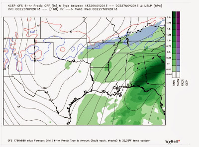
| This is the GFS valid next Monday at noon and it shows you precipitation over the previous 6 hours. There's a light wintry mix over SOUTHERN Arkansas. Yesterday's blog video pointed out the disagreement I had with the suppressed surface low on the GFS. I think it will likely track a little north and this would take any chance for frozen precip up to western and northern AR. We'll see, but that is typically what happens. I can't rule anything out with it being several days away. Anything here would be light and it would likely changeover to a plain, cold rain. |
 |
| Look at how far south that surface low is located on the GFS! The circle south of New Orleans in the Gulf is that low. I think it's too far south. The Euro is a tad further north. Nevertheless, by Tuesday morning, we're getting a plain cold rain, BUT the GFS does show pockets of wintry weather over the higher elevations of western AR. Look at OK to MO. That's on the back side of the system. As I noted above, that could change the rain over to a light wintry mix before ending. |
 |
| And here is late Tuesday and there's the changeover to a light wintry mix over FAR NORTHERN AR. The low is pulling away and that should bring dry and cold weather on your trip to grandma's house Wednesday. |
 |
| And this is for FUNSIES. I WANT TO BE ON THE RECORD BY SAYING, THERE IS VERY LITTLE CHANCE THIS WILL VERIFY!!!!! This is the European model snowfall accumulation with the system next week. We can all dream right? |


No comments:
Post a Comment