
Alright... maybe not madness, but I like alliteration! It's Wednesday December 10th and we're now 5 days out from the Monday system and I don't like what I see (for snow lovers). It seems as if everything is converging on a northerly track of the strong upper low which means the chance for any wintry weather is gone. This can of course change, but I never wanted you to get your hopes up.
An adjustment a little further south and we can have a new ballgame, but you can't deny what all the data says. At this time, it looks like we'll have a round of rain and a few thunderstorms. Instability is really lacking so the severe threat is low. There's a chance we'll get "dry slotted" following the initial surge of moisture. All this means is a push of dry, southwesterly winds for a period of time. It usually only lasts a few hours at most. Then moisture may start to wrap around and temperatures begin to fall, clouds move back in, and a few showers can be expected, especially for areas closer to the upper low. At this time, it appears there could be snow, but the best chance will be north of the state.
Now that takes us into the last 2 weeks of the month. I really think we are going to go into a colder pattern the last 10 days with an active storm track. This does NOT mean snow, but it's a start in the right direction after the mild weather we have been having. I see a ridge building along the west coast into western Canada. This will help dislodge the cold air and send it south. At the same time, the southern jet may get involved and send a series of storm system across the country. Again, it doesn't mean wintry weather, but you at least we may have something to watch!
 |
| The overnight run of the European model shows the upper low well north of Arkansas late Monday. This is wayyyyyyyy too far north for any wintry weather around here. This is a big adjustment from previous model runs so hopefully it's a hiccup. However, the GFS also has a northerly track so this may track up into Missouri... Not good for snow lovers. |
 |
| The GFS is further south of the Euro late Monday, but it's still wayyyyyyy too far north for any wintry weather. |
 |
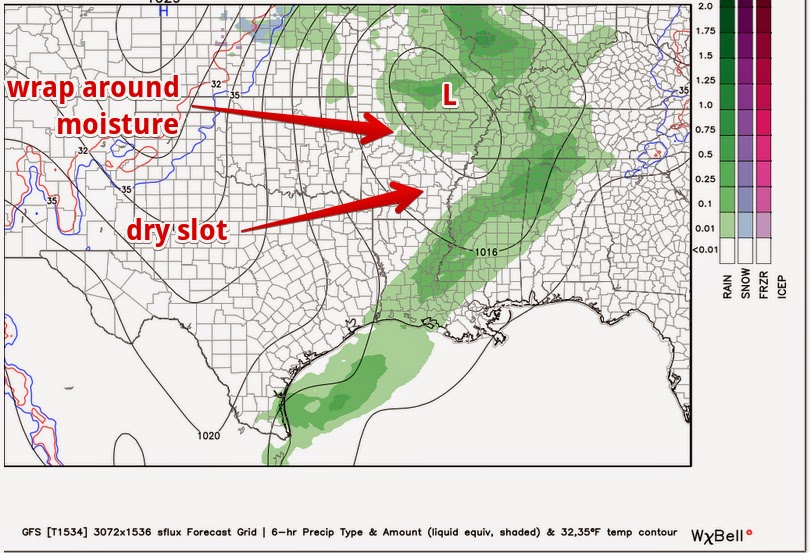
| This is the GFS courtesy of weatherbell.com. At the surface, you can clearly see the first wave of moisture in western Arkansas. Behind that, a southwesterly flow into the low (on the Kansas/Oklahoma state line... black closed circle), produces a dry slot. You can see the blue up into Kansas northwest of the track. That's snow. As you can see, its' well north of the state. |
 |
| By late Monday, the dry slot has punched into the state and moisture is wrapping around the upper low in northern Arkansas. According to this, it's too warm for any wintry weather at that time, but chilly rain showers can be expected up north late Monday. |
In summary, we are still 5 days out from this potent low, but all signs are pointing to plain rain and a few rumbles of thunder. Of course this can change, but I have my doubts. Let's just be patient and wait until the last 10 days of this month. Winter hasn't even officially started yet so there's still plenty of opportunity.


1 comment:
As long as it isn't in the 60s or 70s for Christmas I'm fine with whatever happens. I hate when we get stuck with warm weather for the holidays, it just doesn't feel right.Would LOVE snow but I'll take rain as long as we aren't nearly 70 degrees with tornado activity possible. We can do without that!
Post a Comment