TWITTER: KATV_WEATHER
12:30 PM Wednesday update... Now the Euro is starting to latch onto some accumulation, however it's far eastern Arkansas late Saturday night. With all these models showing some snow, it's hard to believe some place in Arkansas won't see anything. Right now, my thinking are the higher elevations of north central Arkansas into northeastern areas. This is where the best moisture, lift and cold air come together. Could that change? Absolutely!
 |
| This is the AM run of the Euro showing some accumulation across far eastern Arkansas. The models are all over the place with this system, but somethings up! |
10:45 AM Thursday Update... I told you I would let you know if any other models showed what the NAM indicated. Well, we now have the morning run of the GFS and the NAM agreeing on the possibility of some accumulating snow starting in portions of central Arkansas going into northeastern areas. We are now officially putting snow in our forecast at Channel 7 for portions of northern and northeast Arkansas. With temperatures right around or just above freezing and warm ground temperatures, travel problems would be minimal. Unless, it came down so hard and fast it wouldn't have time to melt. The time frame looks like after sunset on Saturday into early Sunday morning. But temperatures Sunday go well above freezing so any accumulation will be gone fast!
 |
| 12Z NAM from Thursday morning showing some accumulation from central into northeast Arkansas as the upper low pulls out late Saturday into Sunday morning |
 |
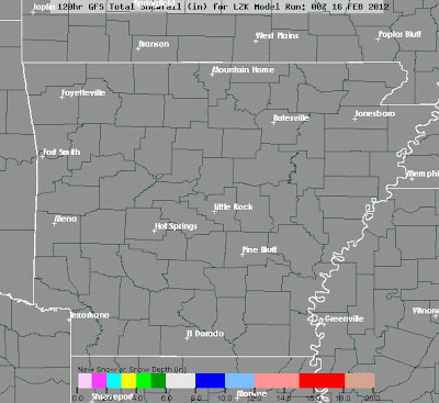
| Now the 12Z GFS indicates the same area could receive some snow accumulation, but the amounts look less compared to the NAM |
I could be accused of "wishcasting", but there is some model support in particular, the NAM (North American Model). To understand where I'm coming from, you must go back to last December. For days, I looked at the 500 mb charts at a strong area of low pressure and wondered why the models showed absolutely nothing in terms of precipitation. I thought the models must know what they're doing, but in the back of my mind, I heard the voice of a meteorologist in Chattanooga, "Those vort maxes will get you everytime". We ended up with 1.6'' of snow in Little Rock in just a few short hours. This system Saturday has some similarities to the December system.
First of all, it looks too warm for anything but rain most of Saturday according to all the model data. The problem... the lowest level of the atmosphere is too warm, but that can cool once the upper low tracks across the state. This area of enhanced "lift" can cool the atmosphere and produce frozen precipitation and you don't even need arctic air in place. The National Weather Service in Memphis even mentions the possibilities in their morning forecast discussion. This system has a favorable track, BUT the cold air is lacking. IF there's any snow, it would come with that upper low late Saturday into Sunday morning.
With all that said, I'm not going to be fooled and I'm going to watch this system like a hawk. While our official forecast calls for rain, please check back. I want to make it clear right now, DON'T GET EXCITED. The only way I'm going to really start to bite on this is if the NAM has other model support and it really doesn't. To some extent, the Euro shows the "540 line" sinking south with the upper low, but the model fails to show any accumulation.
Remember, the purpose of this blog is not to stir you up, but to show you what goes into forecasting and all the possibilities that are on the table which makes our jobs tough sometimes. While I hate the boring days of summer, those forecasts are soooooo much easier. LOL
 |
| This is the 06Z NAM forecast for snow. This is the only model showing this and it's going gangbusters for northern Arkansas this weekend. |
 |
| And this is the GFS... NOTHING. Until there is more model support, I'm NOT going to buy the NAM. It's only Thursday so this can easily still change. |


No comments:
Post a Comment