TWITTER: KATV_WEATHER
9:20 PM Tuesday Update... I still think the nicest air mass in several weeks could arrive later this week. It may be the first real sign the back of the heat wave is broken and fall is around the corner. I still have some reservations about the GFS high temperatures due to reasons posted below. While I still think it cools down and less humid air filters into the state, I'm not sold it will be as extreme as the GFS indicates, but there's always that chance.
 | ||
| This is the GFS valid at 1PM Saturday. The extreme heat is well west with northeasterly winds here at the surface as high pressure builds into the region. |
I debated whether or not to buy into the idea, but the modeling is very consistent with a significant trough over the eastern half of the country with a strong ridge of high pressure out west. This northwesterly wind flow aloft will open the door to the possibility for a few shots of somewhat cooler air.
When I say "cooler", I'm talking about temperatures which would be close to "average" for this time of year which are the lower 90s. But here's the bonus to the whole situation.... LESS HUMIDITY.
However, there are a couple of things working against any drastic cool down. First, the sun angle is still quite high and efficient at heating us up. Yes, it is lowering on the horizon as we head into fall, but the August sun is still very, very effective. Add a dry ground into the mix, and it can heat up more than what the models indicate. For these reasons, I'm cautious about any BIG drop in temperatures, but the pattern will favor lower temperatures as the strong ridge of high pressure which brought us all this summer heat moves westward.
Below are model maps....
 | ||
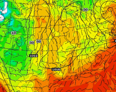
| The GFS dew point map shows lower moisture values with dew point temperatures in the 50s north to 60s south. This would be very comfortable air for August standards, ESPECIALLY at night!!! |


4 comments:
YES! When I saw highs for Saturday and Sunday as 95, I had a feeling that just maybe this could be our cool down as a final wave of goodbye to this abhorred summer!
LOL @ Todd's tweet "#NOTARKANSAUNA"
Next Tuesday is showing a slight warm up at 94 degrees, but after the warm up maybe there could be another cool front? Assuming that we've finally broken the summer pattern, of course, then that would be feasible.
Let's hope that what the Euro is hinting at as Todd tweeted comes to fruition! It's August, after all! I mean now that the most repulsive time of the year is finally coming to an end.
Post a Comment