
It was greeted with skepticism when I sent out a tweet last weekend saying the pattern late this week looked truly amazing. I have never seen something as wild as this in early May and the history books prove it.
I have no changes to what I have been telling you since last Saturday. Record lows will be challenged and there could be flakes of snow falling within our states borders. The most likely place for this is northwest Arkansas.
I want to use this post to show you what our model "Futurecast" says and also list many of the records which are in jeopardy of being broken.
The following is from the National Weather Service office in North Little Rock
                                         FORECAST/RECORD LOW
 STATION                         MAY 3RD        MAY 4TH        MAY 5TH
 -------------------------------------------------------------------------
 LITTLE ROCK                    44/41 1929   39/40 IN 1971   44/43 IN 1945
 JACKSONVILLE/LITTLE ROCK AFB   44/41 2004   39/40 IN 1976   43/43 IN 2005
 NORTH LITTLE ROCK              44/43 2005   39/46 IN 1976   43/46 IN 1979
 RUSSELLVILLE                   41/36 1967   38/35 IN 1954   42/37 IN 1945
 MOUNT IDA                      39/32 1929   38/31 IN 1954   42/32 IN 1945
 HARRISON                       37/31 1911   33/30 IN 1907   39/33 IN 1917
 BATESVILLE AIRPORT             44/37 2005   38/39 IN 2011   40/38 IN 1944
 PINE BLUFF                     45/41 1918   40/41 IN 1954   45/42 IN 1976
 MONTICELLO                     46/41 1960   42/40 IN 1971   46/38 IN 1957
 HOT SPRINGS AIRPORT            42/41 2005   39/40 IN 1976   44/41 IN 2005
 STUTTGART AIRPORT              46/43 2005   38/45 IN 1945   42/44 IN 1945
 ARKADELPHIA                    44/39 2005   40/38 IN 1976   45/39 IN 1945
 BRINKLEY                       46/32 1909   39/37 IN 1954   42/38 IN 1945
 BOONEVILLE                     38/35 2005   37/33 IN 1954   42/37 IN 1945
 CAMDEN                         44/38 1929   41/38 IN 1954   45/39 IN 1925
 CALICO ROCK                    42/30 1976   37/30 IN 1976   38/32 IN 1976
 CONWAY                         44/38 1918   38/36 IN 1954   42/41 IN 1957
 GILBERT                        38/30 2005   35/29 IN 1997   39/33 IN 1945
 HOT SPRINGS NATIONAL PARK      42/34 1909   38/36 IN 1954   44/39 IN 1907
 HARDY                          42/36 2005   36/36 IN 2005   40/37 IN 1917
 MENA                           36/36 2011   38/35 IN 1954   44/38 IN 1945
 SEARCY                         45/37 1929   38/36 IN 1976   40/40 IN 1954
 MOUNTAIN HOME 1NNW             40/35 2005   35/30 IN 1954   38/34 IN 1917
 MALVERN                        45/35 1903   40/35 IN 1976   45/40 IN 1954
 MARSHALL                       38/33 2005   35/31 IN 1954   39/35 IN 1954
 SHERIDAN                       45/40 1960   40/34 IN 1954   45/38 IN 1954
 STAR CITY/CANE CREEK           46/41 1967   40/37 IN 1976   45/45 IN 2011
 NEWPORT                        46/41 1976   38/37 IN 1954   41/40 IN 1954
 CLARKSVILLE                    39/35 1976   37/33 IN 1954   40/35 IN 1954

AT SEVERAL LOCATIONS...THERE IS A LIKELIHOOD OF TYING OR EXCEEDING ALL-TIME
RECORD LOWS FOR THE MONTH OF MAY. STATIONS THAT COULD COME CLOSE ARE LISTED
BELOW.

 STATION                        MAY ALL-TIME RECORD LOW
 ------------------------------------------------------
 LITTLE ROCK                       39 MAY  1ST 1903
 JACKSONVILLE/LITTLE ROCK AFB      39 MAY  7TH 1992
 NORTH LITTLE ROCK                 40 MAY  2ND 1994...MAY 2ND 1978
 BATESVILLE AIRPORT                36 MAY  7TH 1944
 PINE BLUFF                        36 MAY  2ND 1909
 HOT SPRINGS AIRPORT               39 MAY 13TH 1997
 STUTTGART AIRPORT                 41 MAY  1ST 2005
 MENA                              31 MAY  1ST 1903
 STAR CITY/CANE CREEK              37 MAY  4TH 1976
 CLARKSVILLE                       33 MAY  4TH 1954
What about snowfall? Thanks to Brian Smith at the NWS for providing the following information.
The latest accumulating snow was .2'' in Corning, AR set on April 24th, 1910
The latest flakes seen in Arkansas was in Fayetteville, Gravette, and Harrion on April 30th, 1903
The last accumulating snow in Little Rock was .8'' on March 30th, 1987
The last snow was seen in Little Rock was April 19th, 1983.
Top 10 coldest May temperatures in Little Rock
- May 1, 1903 39 degrees
- May 4, 1971 40 degrees
- May 2, 1963 40 degrees
- May 12, 1960 40 degrees
- May 2, 1909 40 degrees
- May 2, 1994 41 degrees
- May 9, 1976 41 degrees
- May 1, 1963 41 degrees
- May 4, 1954 41 degrees
- May 3, 1929 41 degrees
- May 2, 1994 52 degrees
- May2, 2011 53 degrees
- May 4, 1935 53 degrees
- May 4 1907 53 degrees
- May 21, 1892 53 degrees
- May 1, 1994 56 degrees
- May 28, 1992 56 degrees
- May 5, 1935 56 degrees
- May 10, 1924 56 degrees
- May 3, 2002 57 degrees
Let's put this into perspective. That record is May 1, 1903!!!!!!
- The President of the United States was Theodore Roosevelt
- Pepsi company formed
- Niagera Falls runs out of water because of a drought
- Wright Brothers make 1st flight at Kittyhawk
- Loaf of bread was 4 cents
- Milk was 2 cents a gallon
- A stamp was 2 cents
- The average cost of a home was 4,000 dollars
 | ||
| Futurecast is a little slower than other models. The front is moving into central Arkansas Thursday evening at 10 PM. Look at the temperature in Hot Springs at 58 degrees and Stuttgart at 66 degrees. The leading edge of the cold air is moving in from the west. |
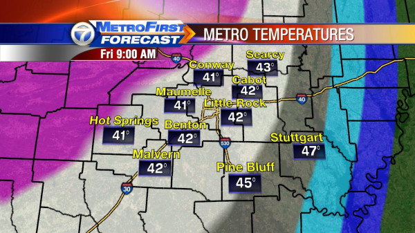 | ||
| Futurecast indicates the low Friday morning will be around 9AM and it will be near close to records. With the wind howling, wind chill readings will be in the 20s and 30s. |
 |
| Futurecast shows highs only in the lower 50s Friday!!!! This could put Little Rock into one of the coldest daytime highs for May in Little Rock weather history. |
 |
| There is some agreement in the models that some snow may occur in far northwest Arkansas. If this verifies, it would be the latest in state weather history. BTW, this is the NAM. |
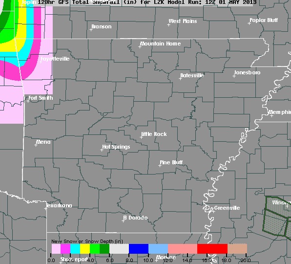 |
| The GFS is also showing close to the same thing with some snow possible for the far northwest. |
 |
| Futurecast shows .3'' possible in Fayetteville... Simply amazing if that happens. |


No comments:
Post a Comment