Just a few days ago the modeling indicated extremely cold arctic air would grip the central portion of the country and send us into a deep freeze leading up to Christmas. At one point, it looked like highs could be in the 20s and 30s with the chance for frozen precipitation on the table.
Let's be clear before I get into this, THIS IS STILL CONSIDERED LONG RANGE AND OF COURSE WILL HAVE TO BE FINE TUNED AS WE GET CLOSER. With that said, the worry for frozen and cold weather has shifted to a heavy rain and thunderstorm threat. First of all, the cold air is not as strong and stays bottled up further north until the surface low passes east of us. Even then, the cold air is nothing unusual. 2nd, this allows the storm track to shift further north opening us up to the warm and humid air from the Gulf of Mexico. Now we have to watch for strong thunderstorms. At this point though, I'm leaning towards a threat for the main threat to be heavy rainfall. If any rough thunderstorms occur, I suspect the best chance will be across southern Arkansas into the southeast United States.
The only chance for winter precipitation will be Sunday night into Monday morning on the back side of the system. There's a small chance for a transition to some wintry weather across portions of northern Arkansas. Looking at the modeling this Monday morning, this shouldn't be a huge problem, but it's worth watching for any changes!
I know this is an important forecast. Many of you have last minute preparations for Christmas and some of you are even hitting the road so I advise you to keep checking back as this significant storm system affects us later this week.
The following maps are from weatherbell.com.
 |
| By noon Sunday, the surface low is located across central Arkansas with heavy rain and thunderstorms. Behind the low, counterclockwise winds grab that cold air and sends it south. That's snow out there in Oklahoma into Kansas and Missouri. |
 |
| Noon next Sunday, the GFS shows a huge contrast in temperatures across the south. Look at the 70s for central and south! The cold air is located just north and west of the boundary. See all that cold air pouring in behind the low in OK! That will eventually get into Arkansas, but not until Sunday night and Monday. IF THIS MODEL VERIFIES, THIS OPENS UP THE POSSIBILITY FOR STRONG STORMS AND HEAVY RAIN. |
|
 |
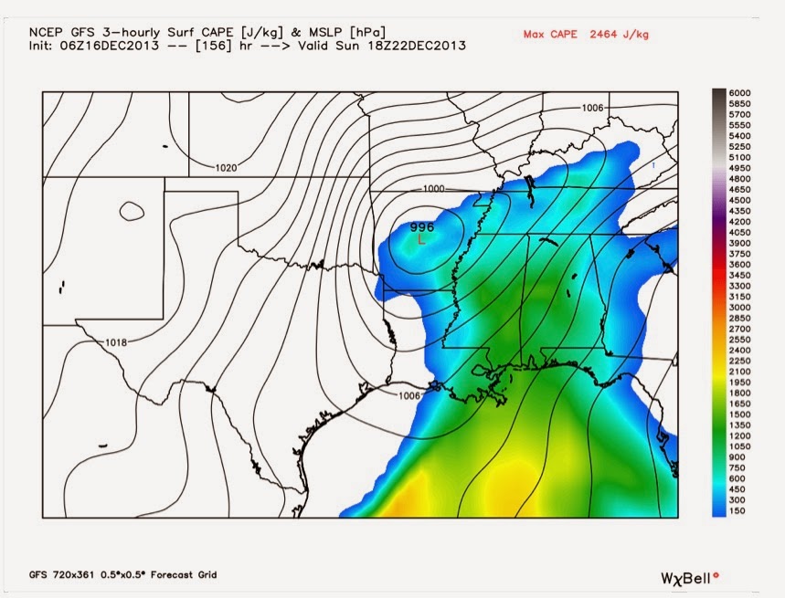
| Noon Sunday and the GFS shows substantial instability, especially southeast of Arkansas. But there's plenty here too. This is CAPE... Convective Available Potential Energy. It's like the gas that makes your car run. This is the fuel which makes storms. The combo of warmth and humidity will contribute to this threat... IF THIS MODEL IS CORRECT. |
 |
| By 6 PM next Sunday, the GFS indicates the cold air is punching into central Arkansas as the surface low moves northeast. Temperatures would tumble and the attention would shift to wintry weather with moisture on the back side of the system. |
 |
| By midnight Monday morning, the rain is changing to light snow across northern Arkansas before ending. This doesn't look like a major storm for us, but it could be further north of the state. |
 |
| Maps from the Weather Prediction Center indicates rainfall amounts in excess of 3 inches across much of the state next weekend. I think there could be a bit more than this. |
In summary, please remember this is still the long range and you can't take these maps literally. The exact track and timing of the low is still very much in question. If it goes further north, it brings in a greater threat for strong to even severe thunderstorms. If it takes a track further south, it would allow colder temperatures to move in and bring a wintry threat. Right now, there's a greater chance for a track further north. Stay tuned.


1 comment:
Todd-You got me twice on the dumb and dumber video. Are the models starting to trend colder again? Or, was that part of the joke? That's ok, because we like a little levity when rain is being forecast instead of fluffy snow.
Post a Comment