
We need some rain, but hopefully it's not all at once. I feel like I have been talking about this upper low for more than a week. Remember, these are extremely slow moving and like I said, knowing exactly who will have the highest impact is tough to predict until it gets here. Right now, it looks like southwestern and southern Arkansas will have several inches of rain over the next several days. Hopefully this is spread out and doesn't come down in a short period of time. With that said, expect localized areas of flooding.
While a few areas of rain will be possible at night, it's the heating of the day which should increase the number of showers and thunderstorms. I would not be surprised to have a strong or even severe storm or two, but by far the main threat appears to be heavy rain. While the strength of the upper low will decrease over time, it will stick around for several days. The coverage of showers and thunderstorms should decrease later this week into the weekend. But what's beyond that?
It appears ridging will take hold over portions of the central United States in the long range bringing a spell of very warm to hot weather. The rains this week will increase the soil moisture and humidity values may become quite high. At the same time, temperatures may not soar to extreme levels. The suns energy will be focused on evaporating whatever water is out there. So temperatures may stay in check, but humidity values will crank the "heat index" to some wretched levels.
 |
| I'll use the European model since it has handled this upper low well. This is valid Thursday and it indicates the low is just southwest of the state. This puts it a favorable position for continued rain chances. |
 |
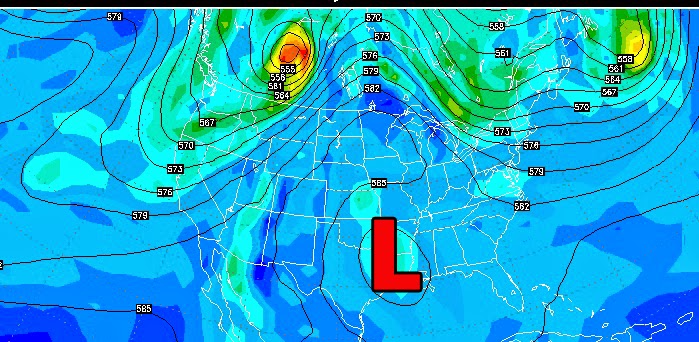
| Exactly one week from Thursday, notice the development of ridging over the southwest United States and southern plains. This will help push heat in from those locations. Under this type of pattern, the southwest corner of the state will have the highest temperatures with cooler weather NE. However, remember, the suns energy will be focused on evaporation at first. Also, this is VERY IMPORTANT. If this pattern were to develop, the flow of air around that high is northwest over portions of the state. This is notorious for bringing clusters of rain and thunderstorms. We'll see how it shapes. up. |
 |
| Look at those potential rainfall amounts over the next 5 days! More than 4 inches may be possible across the south. Remember, turn around, don't drown! |
 |
| NOAA is banking on a good chance for above average temperatures in the 6-10 day time period. |


No comments:
Post a Comment