This is going to be an interesting storm system to follow over the next 2 days. While most of today (Friday) should be uneventful, rain and storms will move in tonight. There may be enough instability for a few strong storms tonight and there could be some small hail.
Then I think much of southern and maybe central Arkansas will get "dry slotted" for awhile as the surface low strengthens. Cold air will wrap around the low and temperatures will fall once that low passes by your location. The moisture in the cold air just north and west of the track will change to snow and that favored area is northwest and north central Arkansas. Is it possible to have flakes fly as far south as central Arkansas? Yes, BUT the chance is not all that great and there should be NO accumulation. Flurries at best.
I can't stress this enough.. this is NOT a major storm and its main impacts will be across north central and northwest Arkansas.
MUCH colder air will be felt with strong winds Sunday bringing down wind chill values. I really thing the models may be a touch too warm next week, but that's another post for another day. I have a ton of maps detailing EVERYTHING including threats, timing, and accumulation. Snow lovers, this is just the start of a fun January and February!!!! Let's sit back and enjoy! For all of you who do not like winter, you get the other 10 months of the year. LOL
Many of these maps are courtesy of weatherbell.com
 |
Rain and storms will move across the state Friday night into Saturday morning. The severe threat is quite low, but some small hail will be possible along with lightning and thunder. This simulated radar is valid at 6AM Saturday.
|
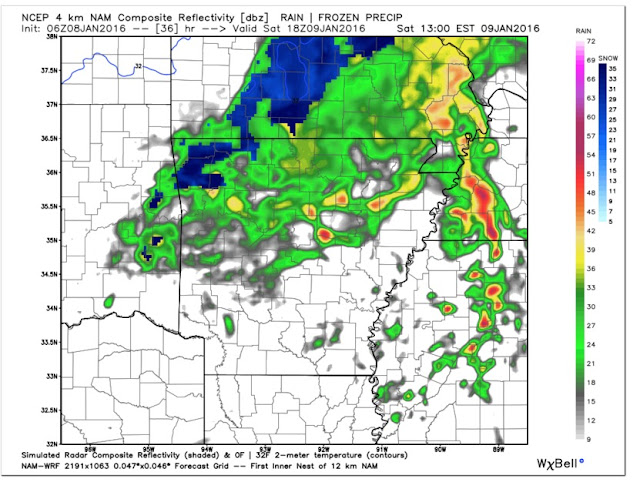 |
| By noon Saturday, the low is pulling into NE Arkansas and cold air and moisture is wrapping around the west side of it. Notice the rain over the north and portions of central Arkansas. Rain has changed to snow over northwest Arkansas. |
 |
| By 3PM, temperatures continue to fall and it's cold enough for snow across north central Arkansas. Cold rain showers further south. |
 |
| I just wanted to show you simulated satellite to illustrate the dry slot. This is at midnight early Saturday morning. There's extensive cloud cover across the state. The blues indicate the higher cloud tops and possible thunderstorms. |
 |
| As the system wraps up and intensifies, by 9AM Saturday, it's pulling dry air into southern Arkansas. the moisture over western and Arkansas and eastern OK is wrapping around the low counterclockwise. |
 |
| The European model shows the possible accumulations over the north and it's all less than an inch, but the higher elevations could see more. Remember, these are only models and this is NOT a big snow maker. |
 |
| The GFS shows something similar. While it's different in amounts, there is agreement where the best chance for snow will be located. |
 |
| Then there's the NAM. I think it's overdone. 4-5 inches? While I can't discount it completely, this model is an outlier. |
 |
| The RPM, which is a model I really do not like. It's run a dozen times a day. It gets one out of 12 runs right and people jump up and down claiming it nailed it. |
 |
| Here's my preliminary forecast and the best course of action at this time. |
BOTTOM LINE... this is NOT a big storm with its main impacts across northwest Arkansas. No need to run out and buy milk and bread. If anything changes, I'll let you know.


No comments:
Post a Comment