
We lost 16 of our fellow Arkansans to one of the strongest tornadoes ever to hit the state. We remember this day for the obvious reasons, but from a meteorological perspective I want to focus on the fact that it "ONLY TAKES ONE." It only takes one storm and it only takes one tornado to wipe out communities, destroy lives, and destroy property.
It was an extremely quiet severe weather season with only 1 tornado in 2014 prior to April 27th. As a matter of fact, we had more tornadoes the first 2 weeks in October of 2014 than we did the entire spring of 2014.
The ingredients were there for a massive outbreak of severe weather and tornadoes that day. Many tornado warnings were issued across much of Arkansas and the highest level of severe weather risk was put in place by the meteorologists at the Storm Prediction Center in Norman, OK.
But by the end of the day, there was only 1 storm which produced tornadoes in Arkansas. The same supercell thunderstorm put down its first tornado near the Saline/Pulaski county line and tracked on the ground for almost 40 miles. It then lifted off the ground and would touch down again 4 more times.
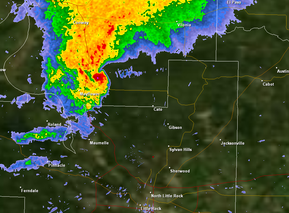
In the calm and quiet studio at Channel 7, we were looking at a horrific signiture on radar, a huge debris ball. While it was peaceful in the weather center, Ned, Barry, and I knew it was hell on the ground and lives were being lost. There was nothing anyone could do and all we could do was urge everyone to take cover. With each radar scan, there was hope it would go away, but it only got stronger.
We quickly began to realize it was happening all over again. The tornado was on the same track as the one which hit Vilonia almost exactly 3 years prior.
That night, I was extremely proud of everyone at Channel 7. Both those behind and in front of the camera put together incredible coverage. I'm even more proud of the way Arkansans responded to the disaster. Within 3 hours of the first tornado warning, we launched the "Spirit of Arkansas Tornado Relief Drive" to help the Arkansas Red Cross respond. Because of you, we were able to give victims almost 250 thousand dollars in relief assistance.
A few years ago, I was asked give a presentation at the National Severe Storms and Doppler Radar Conference in Des Moines, Iowa. Below is a recorded version of that presentation PLUS some of our coverage that night on Channel 7. Also below are radar images from that storm. The National Weather Service in North Little Rock plotted all the survey information along the track and you can check that out on the map too.
 |
| Radar image at 7:06PM |
 |
| 7:10PM Debris ball appears on radar. |
 |
| 7:15PM radar image |
 |
| 7:20PM radar image |
 |
| 7:24PM radar image |
 |
| 7:29PM radar image |
 |
| 7:34PM radar image |
 |
| 7:38PM radar image |
 |
| 7:43PM radar image |
 |
| 7:48PM radar image |
 |
| 7:52PM radar image |


No comments:
Post a Comment