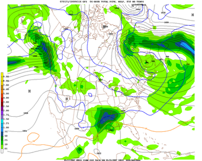
 Two days ago, the models had a low cutting off around the CA coastline, now they are just about all agreeing that it will pull out of the southwest United States and take aim at us late Saturday into Sunday.
 I have posted the noon Sunday surface chart from the 00Z GFS. It shows the 2 meter temperature of 0 degrees Celcius (32 degrees F) running from Dequeen to Little Rock to West Memphis roughly. While thicknesses are generally above the critical 540, I have looked at forecast soundings which indicate the thermal profile from the surface up will be below freezing for central and north AR leaving the south to deal with ice. This of course is too early to make a forecast set in stone, but it does appear the first major winter storm threat for a large chunk of the state is on the way.
It doesn't stop there, another piece of energy could come at us Tuesday/Wednesday.


No comments:
Post a Comment