As many of you know, Andria and I will be having our second boy any day now. While I thoroughly enjoyed Christmas, it wasn't easy for her. She's having a very difficult time moving around and laid down most of the day. She was able to be a spectator to all the action. Judging by all her symptoms, I would be shocked if that baby didn't come this week. But what do I know? I can only forecast the weather, not when someone gives birth. Daddy has many more responsibilities right now. I'm really seeing how much of a "mommas boy" Blake is right now. Nothing wrong with that. He's a great kid.
Now onto the weather. As I have said here on the Arkansas Weather Blog, an area of low pressure aloft will bring its own cold air and bring some snow to portions of Arkansas Monday night into Tuesday morning. YOU DON'T NEED FREEZING TEMPERATURES AT THE SURFACE FOR SNOW TO FALL! This is very important. This is a situation where the temperatures above our heads are cold. Snow will fall, especially across the higher elevations of northern Arkansas. While I don't expect much, I think some minor accumulations will be possible on grassy surfaces. At one time, I thought those places could see a few inches of snow, I'm less optimistic about that, but we'll see what happens.
Here in central Arkansas, I expect all rain. There is a small chance a few snow flakes could mix in with the rain before ending early Tuesday morning. It will be while your sleeping though and I don't expect anything significant at this time. Again, mainly all rain and wet roads.
There's another fight with the models in the long range forecast. The European and the Canadian models are carving out one BIG trough of low pressure across the central and eastern United States. This would bring a blast of cold air and possibly the coldest so far this season. But in the words of Lee Corso, "not so fast my friends." The American GFS, shows the trough, but is less amplified and is more progressive with it meaning it moves in and out faster. Which one is right or will there be something down the middle of the road? Only time will tell. As you know, the models this season have been horrible in the long range so I expect much to change with the forecast to open 2012, but it will be something to follow. You know I'll keep you updated here, on facebook: Todd Yakoubian, and twitter @katv_weather.
Check out the model maps below...
 |
| Our model "Futurecast" shows where the flakes may fly Monday night into Tuesday morning. I only expect small amounts in the higher elevations at this time. I'll keep you updated with any changes. |
 | |
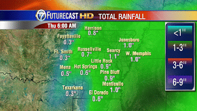
| "Futurecast" rainfall amounts will be around an inch for central into southeast Arkansas. Lesser amounts can be expected across the west. |


5 comments:
This blog is dead. No intresting weather to speak of. Just stinking rain rain rain. Little rock over 60 inches for the year. Well december is almost gone we did get 1. 6 inches of snow. More then a average december. All the arctic air bottled up in the north pole lol. Looks like maybe in a few weeks we can get some cold air. In the mean time BORING BORING! !!!!!
Great job Todd showing us the possibilities down the road. These models never all agree this far out. We are due for some cold weather. As far as i can remember it has always dropped in the teens for low temps in cen ark at least a couple times every year.
Getting some sleet in Conway.
If im not mistakem the little rock airport has had 23 inches of snow the past 2 winters. I would bet we will prob come down to earth this year. Has not been a snowy winter really anywhere in the country. Snowbird has been quiet lately on here. Whem he is not postong u know were in a unfavorable pattern. Lol
This morning the snow cover maps show less than a quarter of North Dakota, Minnesota and Wisconsin covered with an inch of snow. I don't remember this happening in recent times this late in December. Might mean that we have some late invasions of cold air and snow about January 22 or later. I still think LR gets single digits this winter and a 6 inch snowfall.
Post a Comment