TWITTER: KATV_WEATHER
We couldn't buy a raindrop during portions of this summer. Now it looks like we have good rain chances and some of it could come with a price... severe thunderstorms.
An unusually strong (for August) trough of low pressure located north of Arkansas will drive a front into the state. Ahead of it, unstable conditions will develop leading to the development of hit and miss showers and storms. First, the focus will be northern Arkansas Thursday PM, then central and southern Arkansas Friday. The front may stall across southern Arkansas Saturday and this would keep rain chances going. If we can keep rain coming Saturday and stay north of the front, we could be looking at our coolest day in months!!!!!
Here are all the model maps which explains the situation.
 | ||
| By 4 AM Friday, there's widespread showers and storms according to this model. |
 |
| Let's fast forward to 7 PM Friday. The front is slowly easing across central Arkansas with showers and storms scattered around the area. |
 |
| The HPC shows the location of the front early Saturday morning. It has gone stationary across southern Arkansas with waves of low pressure keeps rain chances going. |
 |
| The NAM shows widespread rainfall across the southern 2/3 of the state Saturday morning. IF this verifies, temperatures would struggle to rise behind the front with clouds and rainfall. |
 |
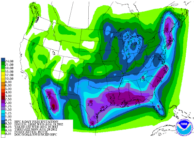
| HPC shows the potential for the most rainfall will generally be located across the southern half of the state where the front slows down and waves of low pressure move across the area. |


No comments:
Post a Comment