

Transitioning from very mild to colder weather can come at a price unfortunately. This ride may get a little bumpy this afternoon and evening as the cold front plows through the state. I expect showers and thunderstorms to develop and eventually form into a line. I still think wind and hail will be the main threat, but an isolated tornado can't be ruled out. The amount of instability will depend on cloud cover today. The more clouds the better. This will help minimize the severe potential. We must watch any individual cells that develop and any storms which form ahead of the main line. Like I said, the tornado threat is low, BUT it is there.
I expect the front to move through central Arkansas early this evening putting an end to our severe weather threat. The winds will howl out of the north at speeds around 15-20 mph with higher gusts. Temperatures will not get out of the 30s across northern Arkansas Monday and will hover in the low to mid 40s central and south. Overnight lows Tuesday and Wednesday morning will easily drop into the teens and 20s statewide making this air mass the coldest so far this season.
Now what about the much talked about snow? I really wish I could get excited about those chances. You know me, I LOVE snow and cold air! However, the ONLY model which indicated that chance has backed off of it significantly with the latest couple of model runs. Of course this can still change, but it's lining up with the other models that say no to snow. HOWEVER, I still think we will get reports of early morning sleet and snow flurries/showers especially north and east of the metro. As I have said all along, this shouldn't be a big deal. The set up is just not ideal for anything significant. Temperatures will be above freezing. Ground temperatures will be warm and the ground will be wet from the recent rainfall. Hard to get anything to accumulate with those conditions. Like I said, don't be surprised to see a few sleet pellets or snow flurries. I hope it puts you in the Holiday spirit. You will know when a chance for real snow occurs. I'll go nuts here on the blog. LOL
Here's simulated radar from the hi res NAM.
 |
| At 1PM this afternoon, the NAM indicates storms developing in southwest to central Arkansas. At this time the front is in northwest Arkansas with temperatures there falling through the 40s. It's mild and muggy everywhere else. |
 |
| By 6PM, an almost solid line of storms is sweeping through southwest, central, and northeast Arkansas. This is associated with the actual cold front. These storms will have the ability to produce wind and hail. An isolated, brief tornado can't be ruled out here. The thing to watch according to this are any cells which develop ahead of the main line. Those tend to rotate and I'll watch that for you. |
 |
| By 2AM, the front is out of the state, cold air is pouring in and showers continue to affect the southeastern half of the state. At this time, temperatures are falling and the winds are howling. Look at the precipitation over Texas and Oklahoma. This is the upper wave we have been watching for any chance for snow or sleet. As this wave moves east, it should dampen out and not have much moisture to work with since it will be swept east with the front. This is not an ideal set up. |
 |
| By 9 AM Monday, the NAM really shows much of the moisture east of the state. It's cold and windy out there though! I do think it is possible to have a few snow flurries, snow showers, or sleet pellets across western, central into eastern Arkansas. However, like I said, the models are backing off on this and it shouldn't be a big deal. |
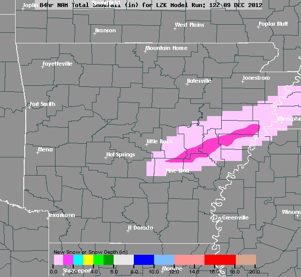 |
| This is the early Sunday morning run of the NAM. It shows snow just east of Little Rock along I-40 to Memphis. These amounts are much, much lower than what this model forecast on Saturday. It's starting to come in line with models that say no to snow. Remember, I do think it is within the realm of possibility for a little light wintry mix before it ends. We'll see. |
 |
| The SPC indicates the slight risk for sever weather in yellow later today into the evening. |


1 comment:
This is gonna be The Winter without Snow I feel like.
Post a Comment