
After reviewing the latest data this Tuesday morning, it appears the forecast is still on track. I expect a line of thunderstorms containing damaging winds and heavy rain to push through the metro after sunset. There will be a tornado threat, but the damaging wind threat is much, much higher. I know I have been probably annoying you about this for days now, but I really am concerned about the lingering effects of the Christmas Day storm. There are so many weakened trees and some are still hanging on lines along the side of the road. Just drive down Kanis Road in west Little Rock and you can see it along the north side of the road. A strong gust of wind will knock these down easily and could injure or kill someone driving by. I hope whoever is responsible for this and all the other problems like this in central Arkansas can clear this up today. Clogged storm drains with debris will not allow water to flow properly so street flooding will be an issue.
Once again, when you step outside today, you will know something is up with our weather. It's going to be warm, windy, and humid... feeling like April! While a few showers will be moving through, the line of severe thunderstorms will not affect us until after sunset. I fully expect tornado watches to be issued for most of Arkansas later this afternoon in anticipation of the storms. Most of us will experience the line and it will only last for a short period of time. Once it moves into your location, the winds will gust and the rain will come down heavily, then it will be over. While NOT to the extent of the Christmas day snowstorm, there will be power outages so prepare for that.
As mentioned above, the tornado threat is there. If any cells develop ahead of the main line, then those could produce tornadoes. Also, there could be areas within the line that spin up. Remember, this threat is NOT as high as the damaging wind threat.
Check out the maps below for specifics.
 |
| Most of the state is under a moderate risk for severe weather from the Storm Prediction Center (SPC) |
 |
| The area in red means there's a 15% chance for a tornado to occur within 25 miles of any given point. That's fairly low, but the threat is there! |
 |
| This is the biggest problem. Most of the state has a 45% chance for severe winds withing 25 miles of any given point in the purple shaded area. |
 |
| The hail threat isn't too high. It's at a 15% chance for severe hail within 25 miles of any given point. |
 |
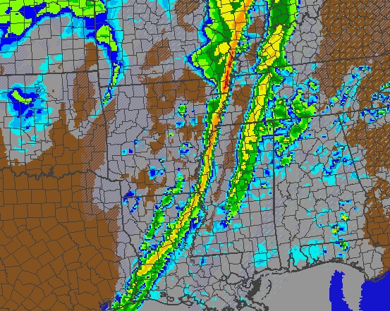
| This is NOT perfect, but simulated radar from the NAM shows the line of storms moving through western Arkansas around 8 PM. This line will have damaging winds with it. We'll watch for any cells in front and anything that spins within the line. Most of this will be "linear" which means high winds. |
 |
| By 10PM, the line is moving through central Arkansas. Other models are a bit faster than this. The same threat described above applies here. |
 |
| Around midnight the line is moving across the MS River and the severe threat is OVER. |


No comments:
Post a Comment