
As discussed Sunday night on the 10 o'clock news, there was a chance the Storm Prediction Center would upgrade portions of the slight risk area to a moderate risk. That happened this morning and you will see the map below. This moderate risk does include Little Rock, Benton, and Bryant and all points east and south.
The SPC (Storm Prediction Center) categorizes severe thunderstorm risks 3 ways: slight, moderate, and high. As we get closer to the event, the data gives us a higher degree of confidence about what will happen. As of right now, I still think this will be a severe line of thunderstorms with very high winds the big threat. However, the tornado threat is elevated in the moderate risk area due to a few things. It appears instability, shear, and the low level jet will combine to enhance that threat. Even the slight risk area could receive an isolated tornado or two, but it's still on the low end. Below are details on what's happening plus and explanation of a moderate risk.
 |
| The area outlined in red shows who is in the moderate risk. This includes the entire Little Rock metro area east and south. |
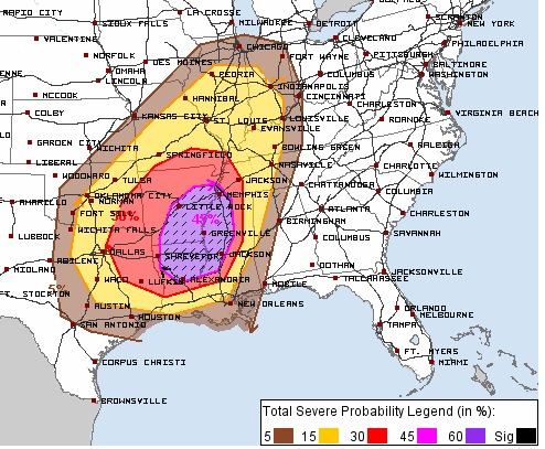 |
| The area outlined in purple indicates there is a 45% chance for severe weather to occur within 25 miles of any given point. |
 |
| This chart explains what a moderate risk means when issued in the "Day 2 Outlook" There's a 45% chance for severe thunderstorms with high winds, hail, and even tornadoes to occur within 25 miles of any given point within that area. |
 |
| Once we get to "Day 1" which will be issued late tonight, you can see this is broken up to address each mode of severe weather. |
 |
| Tuesday evening, the NAM indicates quite a bit of instability for this time of year across portions of southern central and eastern Arkansas. This is known as CAPE (Convective Available Potential Energy). Once you get this up above 800-900 this time year, it really causes concern. |
 |
| This is called the EHI, Energy Helicity Index. It combines both instability and shear into one index. Once above "1", we really start to look for a tornado potential. This is a map from the NAM indicating that potential later Tuesday evening. Just a couple hours before this snapshot, the threat IS a little west of where this is shown. |


No comments:
Post a Comment