It was "Super Tuesday" as many headed to the polls, then headed for cover as a major tornado outbreak hit the central portion of the country. Arkansas was in the middle of it. By the end of the day, an EF4 tornado tracked almost 122 miles continuously through western and northern Arkansas. It was the longest track in recorded state weather history. That single tornado claimed 13 lives and according to the tornado history project web site, almost 140 were injured. A total of 12 twisters tore through Arkansas February 5th, 2008, 14 died, and almost 180 were injured.
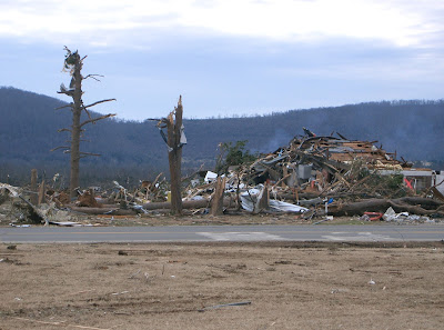
It was a day none of us will ever forget. The next day I was sent to Atkins to look at the damage and it was more heartbreaking than I ever imagined. I saw homes and lives ripped apart.
Below are radar animations of that day, pictures I took, and some viewer photos as well. Let's hope we never have anything like this again.
In this radar animation, you will see the supercell in front of the main line which caused the record breaking twister. This was a text book example of an individual cell in front of the main line rotating. We always watch those storms closely and now you know why.
When the main line came through Little Rock, it produced the 2nd highest wind gust EVER recorded in Little Rock weather history at 67 mph. Below is an animation of that line coming through during the evening hours.
 |
| The actual tornado as it hit Atkins sent in from a KATV viewer. |
 |
| Another shot of the historic tornado as it moved into northern Arkansas. |
 |
| Photo courtesy of the National Weather Service in North Little Rock. This is an aerial view of the boat plant destroyed in Clinton, AR |
 |
| Track courtesy of the Tornado History Project |
 |
| This and the following few pictures I took in Atkins the next day. |
 |
| Atkins, Arkansas |
 |
| Atkins, Arkansas |
 |
| Photo from KATV crews the next day in Clinton, Arkansas |
 |
| Clinton, Arkansas |
 |
| Mountain View, Arkansas damage |
 |
| Here's the convective outlook that day ( 2-5-08) issued by the Storm Prediction Center. High risks are rare! |


No comments:
Post a Comment