TIME TO TAKE A QUICK BREATHER AFTER THIS WINTER/SEVERE WEATHER. I WILL HAVE A BLOG POST SOON DEALING WITH YET MORE ACTIVE WEATHER OVER THE NEXT 7-10 DAYS.
ALSO, I WILL UPDATE THE WINTER WEATHER CONTEST AS SOON AS I GET ALL THE OFFICIAL NUMBERS. WE SHOULD HAVE A NEW LEADER WITH ONLY A FEW DAYS LEFT!
_____________________________________________________________________
Every single type of precipitation will fall in Arkansas over the next 24 hours: rain,snow, sleet, and freezing rain. There could even be some hail across far southeast Arkansas as the Storm Prediction Center has placed that portion of the state under a slight risk for severe weather What better name for this than the "Arkansas Slushie"?
This is one of those storms where you have winter storm warnings on one end of the state and severe weather on the other. I know this might strike some people as odd, but this happens usually once, twice, and sometimes 3 times a year in patterns like this. I want to make it clear though, the risk for severe weather across the SE is "slight".
As discussed in the blog video below, I do think some areas of western, northern and portions of central Arkansas will see sleet and snow to start. The rapid warming of the air aloft will cause a significant melting layer to develop tonight into Thursday from south to north. At the same time, the air close to the ground will stay around freezing. This is a recipe for freezing rain. As expected, an ice storm warning has been issued for areas from Waldron to Danville up to Russellville and into north central Arkansas. Ice amounts could be at least .5'' or greater contributing to downed trees and power lines. Make preparations now. I expect all precipitation to be out of here by late Thursday afternoon.
 |
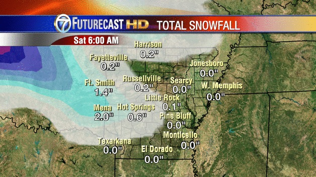
| 00Z Futurecast shows some snow accumulations today into early tonight before the transition to ice. This is mainly for western and northern Arkansas, although we could see a little here in Little Rock. |
 |
| The following maps are from the 00Z Euro model. This is valid noon Wednesday. The 32 degree line is in dark blue. Despite it being north of central AR, I do think a mix of rain, sleet, and snow will fall where you see the blue and green blobs. |
 |
| By 6PM today, you can see pockets of subfreezing air over western and northern Arkansas where it's precipitating. This is when the bulk of this storm will start. |
 |
| By Thursday at 6AM, there's a mix bag of precip over the north and west and some of this could be in central Arkansas. Remember to look at the dark blue line. That's the 32 degree line at the surface. Everyone north of that is cold enough for ice. I do think it's possible the subfreezing air makes it a bit further south. Any ice in central Arkansas Thursday morning should change to a cold rain, but stay frozen in the north. |
 |
| Between 6 AM and noon Thursday, heavy amounts of icing will take place north of that dark blue line. That's west central to north central AR. During this time period, some places could see .5'' of ice or more. In the metro, we SHOULD gradually warm above freezing. |
 |
| Between noon and 6 PM Thursday, the precip. is leaving the state. |
 |
| The Euro thinks snow fall amounts will be confined to west central Arkansas to the north and could be several inches before changing to ice. I think this could be a bit overdone. |
 |
| This is the GFS and the following maps are from the overnight run of the GFS. This does show some snow accumulation in the blue shaded area. Primarily early in the event. |
 |
| The GFS is a bit colder and shows that dark blue line over western and northern AR at 6PM today with precip coming down in the form of sleet and snow. |
 |
| By 6 AM, you can see this is mostly freezing rain and it does encompass the northern half of the state. |
 |
| By noon, the freezing line does move north and out of the metro. However, there are heavy amounts of precip across the north falling into subfreezing air. This is why an ice storm warning is in effect there. |
 |
| This is the Euro total precip. The area of concern is from west central to north central AR. Some of this is melted snow, but it's also large amounts of freezing rain. This says .5 to 1.5'' total precip could fall here. |
 |
| HPC says through 6AM Thursday, much of the NW half of the state will likely see at least .01'' of freezing rain. NO surprise here. |
 |
| And this continues Thursday for the north where heavy amounts of ice are expected. |
In summary, this is playing out as planned over the past couple days. I expect sleet and snow reports today from western to central into northern Arkansas. As the air aloft warms, this will change to freezing rain for central AR tonight, then plain rain later Thursday morning. At this point, it appears any travel concerns for central AR will be later today, tonight, and early Thursday morning. Over west central to north central Arkansas, you may go from sleet/snow over to freezing rain and stay there for the majority of the event contributing to high amounts of ice accumulation. This is the where an ice storm warning is in effect. Make preparations now. I do think power will go out for some of you. Stay safe.


2 comments:
I'm sure this has been explained before, but I don't understand the difference between freezing rain and sleet. I get that it's some sort of atmospheric thing, but why is freezing rain more "dangerous?"
Wow, if only it were 3 degrees colder!
Post a Comment