We told you late last week snow was possibly on the table for late this week and you see the forecasts out there now. One person in frustration even unfollowed me on twitter because she was so upset about the snow potential. Anyway, just remember where you heard about it first, the Arkansas Weather Blog. I still think this is mainly a northern Arkansas snow and ice event and a cold rain in central and southern sections. That's my story and I'm sticking to it. Wild weather eh? Spring break has been no picnic around here!
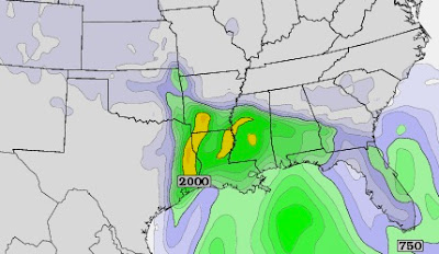
Now onto the tremendous model differences Saturday. Once again we have a huge difference between the Euro and the GFS. It still amazes me to this day people forecast only using the GFS. I wonder if the Euro had MOS output like the GFS if that would ever change? I like to look at all the info. out there to make the best forecast for you. With that said, this is a tough one late Saturday. If you believe the GFS, we could have a round of strong to severe thunderstorms. If you believe the Euro, it's a cold rain. Many of you have seen the stories published in newspapers and on TV about the serious problems the GFS model has compared to the Euro. Make no mistake, the Euro isn't perfect, but it is better and has a great track record this winter. Let's not even talk about the NAM. Although, I will give it credit for last Sunday's forecast. I guess a broken clock is even right twice a day.
I'll have more information about the north Arkansas snow Wednesday, but for now check out the forecast challenges this weekend.
 |
| This is the GFS forecast instability. It's showing significant CAPE (Convective Available Potential Energy) across the southern half of the state. This would support big time storms. |
In summary, many times neither model is correct and it's somewhere in between. This could turn out to be just a rain maker or we could deal with some severe weather issues. After this low passes, MORE cold air will move back in and stay awhile. When I say "cold", I'm talking about relative to average for this time of year. I think it could be well below that too.


No comments:
Post a Comment