Friday, May 31, 2013

More Severe Weather and Flooding Likely


3PM Friday Update.... It still looks like it's going to get active once again.  Channel 7 storm chaser, Michael Hook (the WeatherNinja), is chasing in Oklahoma today.  Watch is live stream below.  Also below are other storm chasers out there.  Click on their car and watch storms LIVE.


Before I get into the severe weather and flooding threat, please get your entries into the 2013 Arkansas Weather Blog summer contest.  Scroll down a little and you will see the post with all the details.  You have until 9PM Friday night to get them in.  We have great prizes including a $100 gas card.  Good luck.

We're going to get a little break today, but instability values should increase this afternoon as sunshine emerges.  There's a ton of moisture in place as well.  Storms that do develop will have the capability to produce very heavy rainfall and flooding.  The ground is already saturated so it will not take much wind to topple trees.  Some locations across western Arkansas have recorded 5-10 inches of rain.

There's a slight risk for severe weather later today for much of the northwestern half of the state.  I expect a few storms to develop in the unstable environment.  A more organized area of thunderstorms will develop in Oklahoma this afternoon.  That will edge into northern and western Arkansas tonight.  Some of these could be severe and produce torrential rainfall.  A front will start to push into the state Saturday.  With daytime heating, the storms should intensify and develop further.  Most of the state is in a slight risk for severe weather, but I'm really going to focus on the southeastern half of the state.  Wind, hail, and even isolated tornadoes will be possible.

Much drier and cooler air will move in Sunday.

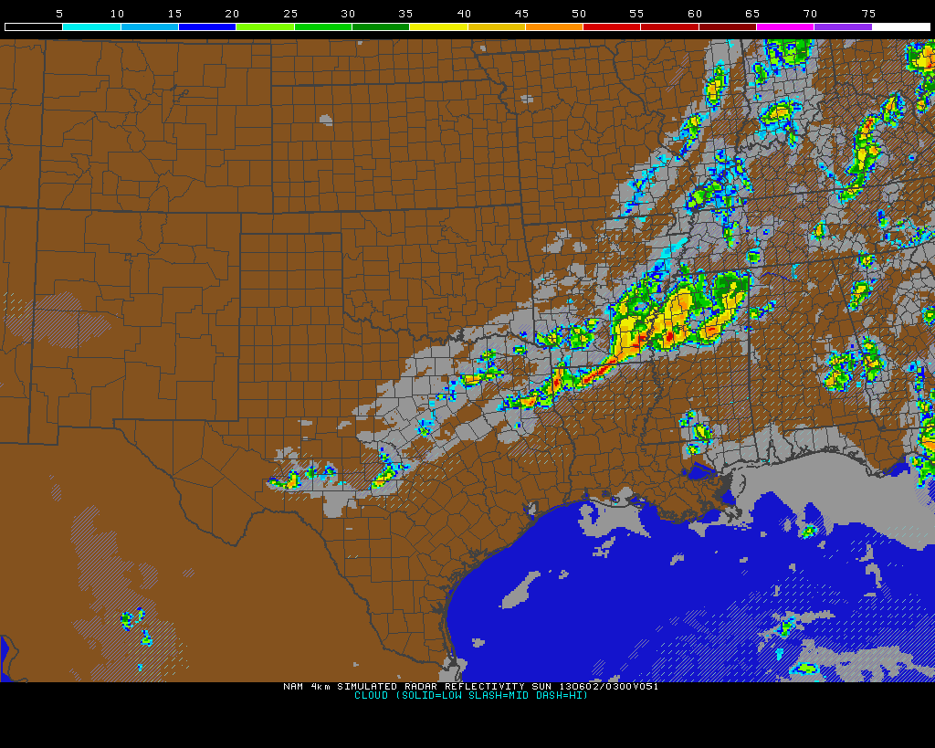
I have hi res maps below showing you simulated radar.  Let me say now, it will NOT be perfect.   There are left over boundaries from yesterday's storms which could be the focus for more storm development.  These small scale boundaries are tough for the models to key in on.

10 PM Friday shows storms over western and some storms moving into Northwest Arkansas.  Any of these could be severe with heavy rainfall as well.

By 7AM Saturday, the area of rain and storms is located across the northern half of the state.  IF, and I do mean IF this verifies, the southern half of the state is rain free and could become very unstable.

By 4PM, Storms are intensifying over southern and eastern Arkansas.  Remember, this will NOT be perfect.
By 10 PM Saturday, strong to severe thunderstorms will be in SE Arkansas and getting ready to exit.
Most of the NW 1/2 of the state has a slight risk for severe weather later Friday.  More organized severe weather is expected across OK into extreme NW Arkansas in the moderate risk.
As the front moves in Saturday, most of the state has a slight risk for severe weather.  The main threats will be wind and hail, but an isolated tornado can't be ruled out.

Wednesday, May 29, 2013

Garland County Tornado Myth

An article which appeared in the Hot Springs Sentinel-Record Newspaper Tuesday, May 28th, was brought to my attention.  The title was "Catastrophe Would Stretch City's Resources."  It's a great look at how that community would deal with the unthinkable EF4 or EF5 tornado.  

I mean absolutely no disrespect to Hot Springs Fire Chief Ed Davis, but I wanted to correct a misconception that I hear all the time.  Here's the quote from the story.


There are so many myths about tornadoes out there and this is one of them.  Strong tornadoes can and do hit mountainous areas.  I hope it never happens to Garland county or ANY place in Arkansas, but no one is immune because of the topography.  No mountain, river, lake, etc will stop or impede a twister.  Check out this map of Garland county tornadoes since 1950 courtesy of the Tornado History Project.

There are several here and many traveled over the hilly terrain.  The Tornado History Project says that since 1950, there have been 34 tornadoes in Garland county, 2 fatalities, 67 injures, the longest path was 28 miles, and the largest width was 1000 yards.

Here's a listing of all those tornadoes.


One of the most notable tornadoes in Arkansas weather history was the EF4 on February 5th, 2008 (Super Tuesday).  This devastating tornado killed 13 Arkansans and traveled a record breaking 122 miles from Yell to Sharp county.  That's a lot of hilly terrain it went over and stayed on the ground.  Here's just a small part of the path in north central Arkansas and it shows the topography it affected well.

Here are some other tornado myths...
  1. Open the windows if a tornado is approaching you.  DON'T do this.  Getting close to glass in high winds can kill you.  Don't ever waste precious time doing this. Get to a safe place.  It was once believed this would equalize the pressure.  Well, guess what, the tornado doesn't care if the windows are open or not.
  2. Never seek shelter under a highway overpass.  This is like a wind tunnel and winds can actually get stronger.
There are many other myths out there, but I just wanted to hit on those two.

Remember, if you're ever under a tornado warning, go to the center portion of your home or business, put as many walls between you and the outside, and make sure you're on the lowest level.  It's also a good idea to have a helmet, a pillow, or something substantial to protect your head.  Flying debris can severely injure or kill you.

Again, I mean no disrespect to the Fire Chief in Hot Springs.  I only want everyone to know the facts about tornadoes. While it is true, Garland county has not had an EF5 tornado, it's worth noting no place in the state has had one since 1929.   We are also the ONLY state in the central United States NOT to have one since 1950.  Our topography varies from the flat Delta to the mountains of western and northern Arkansas.  I have a blog post about this and you can scroll down and find it.

Sunday, May 26, 2013

2013 Summer Contest

Here we go with the 2013 Arkansas Weather Blog summer contest.  We will go with the usual, "Price Is Right" rules.  Whoever is closest without going over will win.  You must send in both your answer to the main question AND the tiebreaker to enter into the contest.  Please don't forget that!  If we do not have a winner after the tiebreaker, the prizes will be a part of the winter contest of 2013-2014.

The contest will run from June 1st through August 31st (meteorological summer).  You MUST have all your entries sent to me via email ONLY and they must be in by 9PM Friday May 31st, 2013.  The email address is weather@katv.com

We have a GREAT prize package this summer.  The winner will receive a $100 gas card, an "Arkansas Weather Geek" t-shirt compliments of the WeatherNinja, 4 tickets to the "Golden Corral" also compliments of the WeatherNinja, and RadarScope for your smart phone.

So here we go.  You must follow these instructions to be officially entered into the contest.
Add up all the high temperatures from June 1st through August 31st for Little Rock.  The official observation station is at the Little Rock airport and that data is kept by the National Weather Service.  For example, if the high temperature is 90 degrees every day for those 92 days of the contest, your answer would be 8280

Remember, you must send in a tiebreaker to be entered into the contest.  For the tiebreaker, what is the total rainfall for Little Rock and North Little Rock to the nearest hundredth of an inch?   The official observation stations are located at the Little Rock airport and the North Little Rock airports.  For example, if Little Rock receives 15.25 inches of rain and North Little Rock receives 16.78 inches of rain between June 1 and August 31st, your tiebreaker answer would be 32.03 inches.  This data is also kept by the National Weather Service office in North Little Rock.

GOOD LUCK!

Wednesday, May 22, 2013

Arkansas and F5 Tornadoes. Is Time Running Out?

Is time running out on Arkansas?  Did you know it has been 84 years since Arkansas has experienced an F5 tornado?  According to the National Weather Service office in North Little Rock, on April 10th, 1929, the only documented F5 tornado in state history destroyed communities around Pleasant Valley, Possum Trot, and Sneed in Jackson county.  These locations are just a couple of miles away from Swifton.  Research from the NWS office indicates the tornado was .5 mile wide.  It began just south of Batesville in Independence county, then tracked into northern Jackson county and ended in far southern Lawrence county.  23 died that day and 59 were injured.

Of all the tornadoes across the United States, since 1950, only .1% are rated F5.  

Take a look at the map below courtesy of the Storm Prediction Center.  Arkansas is the ONLY state in the central U.S that has NOT had an F5 tornado since 1950.  There have been 59 of them in the last 63 years.  The first F5 tornado since 1950 was recorded near Waco, TX on May 11, 1953.  and the 59th was on Monday in Moore, OK.

Look how close some of these F5's have been to our state.

Number 25 is Delhi, LA on February 21, 1971
Number 34 is Sprio, OK on March 26,1976
Number 38 is Broken Bow, OK on April 2, 1982
Number 57 is Joplin, MO on May 22, 2011

What about F4 tornadoes since 1950?  While rare, those do occur in Arkansas.  There have been 27 of these since 1950.  The most well known F4 in Arkansas occurred on February 5th, 2008, when one tracked from Yell to Sharp county.  That's 122 miles long!  It killed 13 Arkansans and injured 139.  You probably remember that occurred on Super Tuesday.

Check out this map from the Tornado History Project of all the F4 tracks in Arkansas since 1950.


Here's a list of all the F4 tornadoes in Arkansas since 1950


In summary, I think it's just a matter of time before this happens.  I REALLY HOPE I'M WRONG!!!!!! I REALLY DO!  However, you must ask how long this streak can continue looking at all the F5's that have hit around us.  We need to think about this! What would you do?  Do you have a plan?  Schools MUST take a hard look NOW at where to put the kids.  This is the time to do it.  Don't wait!

Tuesday, May 21, 2013

Tracking Tuesday Trouble


9:30 AM Tuesday Video Update....


I have been reviewing the data this Tuesday morning and I still think severe weather will be possible this afternoon with southwest Arkansas seeing the worst of it.  That does NOT mean the rest of the state is in the clear.    As I always say, we can look at the data over and over and overMother Nature will do what she wants to do.  As much as we educate ourselves and study this stuff, there's someone else in control!

The morning rain and thunderstorm activity is a good thing and hopefully clouds will stick around.  This will limit the instability needed for big time thunderstorms.  However, if sun breaks out, things could get rough.  The focus for much of the thunderstorm activity later in the morning will be out in Oklahoma, then it should shift into Arkansas this afternoon.  It will form into a clusters of storms and move to the east-southeast and affect western, portions of central, and southwestern Arkansas.  Again, that's where I think the worst of this will be, but other areas will need to keep an eye to the sky as well.  We will all need to watch for the potential for some heavy rain as well.  2-4 inches will be quite possible.

Here are a few maps from the Storm Prediction Center.  Later this morning, I'll post some hi res data for you.  This is my day off from work and I have a ton of stuff going on this morning so check back and I'll have more.

Most of the state is under a slight risk for severe weather, but the moderate risk is for southwest Arkansas into TX and LA.

Most of the state has at least a 5% chance for seeing a tornado within 25 miles of any given point.  The highest threat is across the moderate risk area in the southwest with a 10% chance for a tornado within 25 miles of any given point.
There's a 30% chance for severe winds within 25 miles of any given point with a 45% chance across the southwest.
As far as severe hail (1'' or greater).  There's a 30% chance within 25 miles of any given point for much of AR with a 45% chance across the southwest and west.

Sunday, May 19, 2013

Severe Weather Possible In Arkansas and Chasing In The Plains


We're watching the possibility for some severe weather here in Arkansas late Monday into Tuesday morning and again Tuesday afternoon and evening.  The video below will go over hi res simulated radar and it should give you a good general idea as to how this could unfold.  Remember, models are rarely perfect so things can still change.

Friday, May 17, 2013

Everything You Wanted To Know About The Heat Index, But Were Afraid To Ask

It's not the heat, it's the humidity.  At least that's what we tell ourselves during the long, hot summer months. 

Because the body can't cool itself efficiently with moisture in the air, you feel hotter than the actual temperature.  The equation which is used to come up with the heat index temperature is complex and assumes specific variables.  I thought it would be fun to take a look! It's important to remember that while we use the heat index, it's different for each individual person as the formula assumes everyone is 5'7'' tall,  weighs 147 pounds, etc.  Read all the variables below.

 Heat Index =    -42.379 + 2.04901523T + 10.14333127R - 0.22475541TR - 6.83783x10⁻³T2 - 5.481717x10⁻²R2 + 1.22874x10⁻³T2R + 8.5282x10⁻⁴TR2 - 1.99x10⁻⁶T2R2


where T = ambient dry bulb temperature (°F) R = relative humidity (integer percentage).


Here are just a few of the variables involved.  This is good water cooler chat!

* Vapor pressure . Ambient vapor pressure of the atmosphere. (1.6 kPa)
* Dimensions of a human. Determines the skin's surface area. (5' 7" tall, 147 pounds)
* Effective radiation area of skin. A ratio that depends upon skin surface area. (0.80)
* Significant diameter of a human. Based on the body's volume and density. (15.3 cm)
* Clothing cover. Long trousers and short-sleeved shirt is assumed. (84% coverage)
* Core temperature . Internal body temperature. (98.6°F)
* Core vapor pressure . Depends upon body's core temperature and salinity. (5.65 kPa)
* Activity. Determines metabolic output. (180 W m-2 of skin area for the model person walking outdoors at a speed of 3.1 mph)
* Effective wind speed. Vector sum of the body's movement and an average wind speed. Angle between vectors influences convection from skin surface (below). (5 kts)
* Clothing resistance to heat transfer. The magnitude of this value is based on the assumption that the clothing is 20% fiber and 80% air.
* Sweating rate. Assumes that sweat is uniform and not dripping from the body.
* Ventilation rate. The amount of heat lost via exhaling. (2-12%, depending upon humidity) * Skin resistance to heat transfer. A function of activity, skin temperature, among others.
* Skin resistance to moisture transfer. A function of the vapor-pressure difference across the skin (and, therefore, relative humidity). It decreases with increasing activity.
* Surface resistance to moisture transfer. Similar to heat transfer resistance but also depends upon conditions in the boundary layer just above skin's surface.

Tuesday, May 14, 2013

More Records Could Be Broken This Spring


All the talk this spring has been about the cool weather.  Hundreds of record lows were broken all over the state early this month not only in Arkansas, but across much of the central United States.

When we look at the data from March, April, and May, meteorologists and all the climatological data in the record books call these months "spring".  We're about half way through May with just a little more than 2 weeks until meteorological spring is over and meteorological summer begins. (June 1).

So where do we stand right now in Little Rock?  If spring ended today, it would break all records for the coldest spring on record.
  • The average seasonal high temperature so far is 66.9 degrees.  Number 1 on the list is 67.30 degrees set in 1983
  • The average seasonal low temperature so far is 44.80 degrees.  Number 1 on the list is 45.91 degrees set in 1971
  • The average seasonal temperature 55.85 degrees.  Number 1 on the list is 57.7 degrees set in 1983. 
However, we all know we have plenty of time for these numbers to change.  So let's assume "average" temperatures from now until the end of the month.  How would that stack up with recorded data so far?
  • The average high temperature would be 70.02 degrees and would NOT fall within the top 10 list.
  • The average low temperature would be 48.03 degrees and would be 4th coldest spring on record
  • The average seasonal temperature would be the 7th coldest on record with 59.03 degrees.


NOAA is forecasting a good chance for below average temperatures in the 6-10 day time period which would change my "average" assumptions above
In the 8-14 day time period, NOAA is suggesting temperatures near to a little below average.  This too would change the outcome of my assumptions.

In summary, it's looking likely this spring will go down in the record books as one of the coolest on record in Little Rock since they started keeping them in the 1870s.  We'll see how it all shakes out and I'll let you know!

Sunday, May 12, 2013

Arkansas Tornado History & 2013 So Far


We've made it to the middle of May and our primary severe weather season is almost over.  While severe weather and tornadoes can happen any month of the year, the months of March, April, and May are considered our main severe weather season.  So far this year, Arkansas has had 12 tornadoes.  6 of those occurred in Winter (5 in January and 1 in February) while the other 6 were in Spring (April).  There's more good news so far this year.  We have not had a fatality in the state related to tornadoes, thunderstorms winds, flooding, or lightning.  Let's keep this going!

I want to urge caution though.  Don't ever let your guard down even though we're going into the summer months.  Meteorologist Brian Smith at the National Weather Service office in North Little Rock reminded me one of the worst tornado outbreaks in state history was in JUNE!   On June 5th, 1916, we had 34 tornadoes and 87 fatalities.  This was the biggest outbreak in recorded state history until January 21st, 1999 when 56 tornadoes swept through the state.  According to the tornadoproject.com, at 4PM on the 5th, a tornado killed 25 people and injured 150 on the west and north side of Heber Springs.  There's a discrepancy on the number of injuries that day so I'll have to do some more research on that.   I find it interesting 2 of the biggest outbreaks happened OUTSIDE of the "traditional" severe weather season.  That brings me to my next point.

While we are well under the yearly state tornado average of 33, there's still a lot of time and much can happen.  Remnant tropical systems can bring tornadic activity later in the summer into fall.  Also, during the fall and early winter months, we usually experience an increase in activity as our secondary severe weather season ramps up.  In some years, this has been more active than the spring.

Our somewhat quiet year has been shared all over the country.  While we have had a cool spring so far and some didn't like that, it has kept the potential violence from Mother Nature to a minimum. 

Below are some statistics as well as a look back at that horrible outbreak in 1916


While a lot can change between now and the end of the year, our tornado count is well below average.  2012 was below average as well.  We deserve this considering the violent weather of 2011.

Check out the average number of tornadoes over the past 3 years across the country for each month.  You can really see the spike from March through May.  Also notice the tiny spike in October.  This is most likely due to tropical activity and the secondary severe weather season.  In some years, this spike in tornadoes is much more noticeable.
This is the surface map from June 5th, 1916 early in the morning.  You can see a surface low is analyzed over southwest Oklahoma at 29.40'' of mercury.  A low this far south in June is not typical.  Usually the jet stream (storm track) has retreated well north of this latitude.  In this set-up, Arkansas is exposed to the warm sector of the storm with temperatures well into the 70s at 7AM.
By 7AM the next day, June 6th, 1916, the surface low has moved northeast and strengthened.  This easily explains the violent outbreak of tornadoes that early June day.  The surface low is located near St. Louis and the pressure has dropped to 29.25'' of mercury.

Sunday, May 05, 2013

For The Record... Historic May Cold and Snow


I think it's safe to say this will go down as one of the top weather events of 2013.  There were dozens and maybe even close to a hundred records broken all across the state (I haven't had time to count it all).

We broke records over the past 3 days in several different categories such as:


  • latest accumulated snow
  • latest snow flakes ever seen
  • daily record lows
  • all time coldest May temperatures
  • coldest daytime highs
  • coldest daily average temperatures
The National Weather Service has done a fantastic job of keeping up with it all.  The following contains most of the records, but more will be added I'm sure.

PUBLIC INFORMATION STATEMENT...UPDATED
NATIONAL WEATHER SERVICE LITTLE ROCK AR
420 AM CDT SUN MAY 5 2013

...HISTORIC COLD AND SNOWFALL IN ARKANSAS IN MAY...

.SNOWFALL...

FOR THE FIRST TIME SINCE WRITTEN WEATHER HISTORY BEGAN IN ARKANSAS
/1819/...SNOW HAS FALLEN IN THE MONTH OF MAY. THIS SNOW HAS SET
RECORDS FOR THE LATEST SNOWFALL AND LATEST MEASURABLE SNOWFALL IN
THE STATE.

THE PREVIOUS LATEST SNOWFALL EVER RECORDED WAS ON APRIL 30TH 1903...AT
HARRISON...GRAVETTE...AND FAYETTEVILLE. THIS WAS NOT MEASURABLE.

THE PREVIOUS LATEST MEASURABLE SNOWFALL WAS 0.2 INCHES AT CORNING ON
APRIL 24 1910.

BELOW IS A LIST OF SNOWFALL MEASUREMENTS FROM NATIONAL WEATHER
SERVICE COOPERATIVE OBSERVER STATIONS...AS WELL AS COCORAHS
STATIONS. THESE STATIONS ARE IN BOTH THE NWS LITTLE ROCK AND TULSA
AREA OF RESPONSIBILITY.

COOPERATIVE OBSERVER STATIONS
-------------------------------------------------------------------
STATION                       MAY 3RD          MAY 4TH     TOTAL
-------------------------------------------------------------------
WINSLOW 7NE                     0.4              1.5        1.9
OMAHA                           0.5              1.2        1.7
FAYETTEVILLE EXP STATION        1.5                         1.5
COMPTON                         1.0                         1.0
FAYETTEVILLE DRAKE FIELD        0.5                         0.5
KINGSTON 2S                     0.2              0.2        0.4
HARRISON                        0.1             TRACE       0.1
GILBERT                                         TRACE      TRACE
JASPER                         TRACE                       TRACE
MOUNT IDA                      TRACE                       TRACE
MOUNTAIN VIEW                                   TRACE      TRACE
PARTHENON                      TRACE
RATCLIFF                       TRACE                       TRACE

COCORAHS STATIONS
-------------------------------------------------------------------
STATION                       MAY 3RD          MAY 4TH     TOTAL
-------------------------------------------------------------------
DECATUR 2.6 ESE                 5.0                         5.0
BELLA VISTA 1.5 NNE             1.5                         1.5
PEA RIDGE 0.2 WSW               1.5                         1.5
HARRISON 5.4 SW                                  1.0        1.0
ROGERS 3.8 SW                   1.0                         1.0
ROGERS 2.1 SE                   0.8                         0.8
SILOAM SPRINGS 1.8 N            0.7                         0.7
JASPER 2.7 WNW                                   0.3        0.3
HARRISON 5.4 SW                 0.2                         0.2

OTHER STATIONS
-------------------------------------------------------------------
LOCATION                      MAY 3RD          MAY 4TH     TOTAL
-------------------------------------------------------------------
QUEEN WILHELMINA STATE PARK     0.8                         0.8
CLINTON AIRPORT                TRACE                       TRACE

.COLDEST HIGH TEMPERATURE RECORDS...

DAILY RECORD COLDEST HIGH TEMPERATURES SET OR TIED ARE LISTED BELOW.

                    RECORD COLDEST HIGH TEMPERATURES
                       MAY 3RD           MAY 4TH
-----------------------------------------------------------------------
STATION              NEW  PREVIOUS    NEW  PREVIOUS       RECORDS SINCE
-----------------------------------------------------------------------
BATESVILLE AIRPORT   45  57 IN 2009    48  64 IN 2009          1937
BEEDEVILLE 4NE                         50  61 IN 1978          1964
BOONEVILLE                             55  56 IN 1978          1906
CABOT 4SW                              49  61 IN 2009...1978   1965
CALICO ROCK 2WSW                       40  54 IN 1935          1915
CLARKSVILLE WATER PLANT                50  54 IN 1978          1871
CONWAY                                 48  56 IN 2002          1884
DES ARC                                47  52 IN 1907          1903
FLIPPIN              39  52 IN 1978    43  51 IN 1961          1951
GILBERT                                42  53 IN 1961          1924
HARDY                                  40  51 IN 1907          1897
HARRISON             38  48 IN 1978    44  50 IN 1978          1891
HOT SPRINGS AIRPORT  57  57 IN 2002    51  61 IN 1978          1948
JACKSONVILLE         48  56 IN 1978    51  58 IN 1978          1956
LEAD HILL                              37  52 IN 2009...1935   1927
LITTLE ROCK          52  57 IN 2002    53  53 IN 1935          1879
MALVERN                                57  60 IN 1978          1882
MAMMOTH SPRING                         40  51 IN 1907          1904
MENA                                   55  55 IN 1935          1887
MONTICELLO           56  60 IN 1994                            1876
MORRILTON                              49  57 IN 2002          1919
MOUNTAIN HOME 1NNW                     38  53 IN 1995          1902
MOUNTAIN VIEW                          41  50 IN 1978          1924
NEWPORT                                42  56 IN 1907          1884
NORTH LITTLE ROCK    48  55 IN 1978    49  58 IN 1978          1975
PINE BLUFF           53  60 IN 2002                            1883
RUSSELLVILLE         52  59 IN 2002    51  58 IN 1978          1882
STAR CITY/CANE CREEK                   51  62 IN 1978          1963
STUTTGART AIRPORT    52  54 IN 2004    55  61 IN 1944          1942


THERE WERE MANY STATIONS WHICH SET OR TIED THE ALL-TIME RECORD COLDEST
HIGH TEMPERATURE FOR THE MONTH OF MAY. AT HARDY...A RECORD THAT HAD STOOD
SINCE 1899 WAS SHATTERED BY 10 DEGREES.

                      ALL-TIME RECORD COLDEST HIGH TEMPERATURES FOR MAY
STATION             NEW RECORD           PREVIOUS RECORD      RECORDS SINCE
---------------------------------------------------------------------------
LEAD HILL          37 05/04/2013          44 05/03/2011              1927
HARRISON           38 05/03/2013          45 05/02/2011              1891
MOUNTAIN HOME 1NNW 38 05/04/2013          49 05/03/2011              1902
FLIPPIN            39 05/03/2013          51 05/04/1961              1951
CALICO ROCK 2WSW   40 05/04/2013          48 05/03/2011              1915
EVENING SHADE 1NNE 40 05/04/2013          48 05/03/2011              1923
HARDY              40 05/04/2013          50 05/24/1899              1897
MAMMOTH SPRING     40 05/04/2013          49 05/03/2011              1904
MOUNTAIN VIEW      41 05/04/2013          48 05/03/2011              1924
BATESVILLE L/D     42 05/04/2013          49 05/03/2011              1951
GILBERT            42 05/04/2013          47 05/03/2011              1924
NEWPORT            42 05/04/2013          53 05/02/1994              1884
BATESVILLE AIRPORT 45 05/03/2013          45 05/02/2011              1937
CLARKSVILLE 6NE    47 05/04/2013          49 05/03/2011              1986
DES ARC            47 05/04/2013          52 05/03/2011...05/03/1994 1903
CONWAY             48 05/04/2013          49 05/02/2011              1884
JACKSONVILLE       48 05/03/2013          51 05/02/2011              1956
NORTH LITTLE ROCK  48 05/03/2013          50 05/02/2011...05/02/1994 1975
CABOT 4SW          49 05/04/2013          57 05/03/2002...05/02/1990 1965
KEO                49 05/04/2013          50 05/03/2011              1948
MORRILTON          49 05/04/2013          49 05/03/1994              1919
BEEDEVILLE 4NE     50 05/03/2013          50 05/02/1994              1964
CLARKSVILLE WATER  50 05/04/2013          50 05/03/2011...05/03/1994 1871
ROHWER 2NNE        50 05/04/2013          55 05/04/1978              1959
STAR CITY          51 05/04/2013          62 05/10/2010              1963
LITTLE ROCK        52 05/03/2013          52 05/02/1994              1879
PINE BLUFF         52 05/03/2013          56 05/02/2011...05/04/1978 1883
RUSSELLVILLE       52 05/03/2013          53 05/02/2011              1882
STUTTGART AIRPORT  52 05/03/2013          52 05/02/1994              1942

.RECORD LOW TEMPERATURES...

DAILY RECORD LOWS WERE SET AT MANY LOCATIONS...AND SOME OF THESE
TEMPERATURES WERE THE COLDEST EVER RECORDED IN THE MONTH OF MAY.

                        RECORD LOW TEMPERATURES
                       MAY 3RD           MAY 4TH
-----------------------------------------------------------------------
STATION              NEW  PREVIOUS     NEW  PREVIOUS      RECORDS SINCE
-----------------------------------------------------------------------
BEEDEVILLE 4NE                          38 38 IN 1976          1964
BOONEVILLE                              35 38 IN 1954          1906
CABOT 4SW                               35 36 IN 1976          1965
DES ARC               41  41 IN 2005    37 37 IN 1954          1903
FORDYCE                                 35 37 IN 1954          1911
HARDY                                   33 36 IN 2005          1897
HOT SPRINGS AIRPORT   39  41 IN 2005    36 40 IN 1976          1948
JACKSONVILLE          38  41 IN 2004    36 40 IN 1976          1956
LITTLE ROCK           38  41 IN 1929    38 40 IN 1971          1879
MALVERN                                 34 35 IN 1976          1882
MENA                  34  36 IN 2011    34 35 IN 1954          1887
MONTICELLO            40  41 IN 1960    38 40 IN 1971          1876
MOUNTAIN HOME 1NNW                      35 35 IN 2005          1902
MURFREESBORO 1W                         34 38 IN 2011          1970
NEWPORT               39  41 IN 1976    37 37 IN 1954          1884
NORTH LITTLE ROCK     39  43 IN 2005    40 46 IN 1976          1975
PINE BLUFF            40  41 IN 1918    35 41 IN 1954          1883
STAR CITY                               37 37 IN 1976          1963
STUTTGART AIRPORT     41  43 IN 2005    37 45 IN 1945          1942

AS OF 4 AM THIS MORNING...DAILY RECORD LOWS HAVE ALSO BEEN BROKEN FOR
MAY 5TH AT NORTH LITTLE ROCK...LITTLE ROCK...JACKSONVILLE...HOT SPRINGS
AIRPORT...PINE BLUFF...AND THE STUTTGART AIRPORT.

                      ALL-TIME RECORD LOW TEMPERATURES FOR MAY
STATION             NEW RECORD               PREVIOUS RECORD  RECORDS SINCE
----------------------------------------------------------------------------
LEOLA               32 05/04/2013              34 05/04/2011        1963
SPARKMAN            32 05/04/2013              35 05/16/2002        1963
MURFREESBORO 1W     34 05/04/2013              35 05/01/2005        1970
CABOT 4SW           35 05/04/2013              36 05/04/1976        1965
FORDYCE             35 05/04/2013              37 05/02/1994        1911
PINE BLUFF          35 05/04/2013              36 05/02/1909        1883
HOT SPRINGS AIRPORT 36 05/04/2013              39 05/13/1997        1948
JACKSONVILLE        36 05/04/2013              39 05/07/1992        1956
DES ARC             37 05/04/2013              37 05/04/1954        1903
STAR CITY           37 05/04/2013              37 05/04/1976        1963
KEO                 38 05/04/2013              38 05/04/1954        1948
LITTLE ROCK         38 05/04/2013...05/03/2013 39 05/01/1903        1879
NORTH LITTLE ROCK   39 05/03/2013              40 05/02/1994        1975
ROHWER 2NNE         39 05/04/2013              39 05/03/1978        1959

AT LITTLE ROCK...IT WAS THE COLDEST TEMPERATURE IN THE MONTH OF MAY
SINCE 1903...AND AT PINE BLUFF...IT WAS THE COLDEST MAY TEMPERATURE
SINCE 1909.

IT WAS THE LATEST FREEZE ON RECORD FOR SPARKMAN AND LEOLA...AND THE FIRST
MAY FREEZE EVER RECORDED AT BOTH LOCATIONS.

.DAILY AVERAGE TEMPERATURES...

DAILY AVERAGE TEMPERATURES HAVE BEEN RECORD-SETTING AS WELL. AT SEVERAL
LOCATIONS...THE LOWEST ALL-TIME DAILY AVERAGE TEMPERATURE FOR THE MONTH
OF MAY HAS BEEN RECORDED.

STATION                NEW RECORD/DATE         PREVIOUS RECORD/DATE
--------------------------------------------------------------------
LITTLE ROCK        45.0 DEGREES 05/03/2013   46.5 DEGREES 05/02/1994
NORTH LITTLE ROCK  43.5 DEGREES 05/03/2013   45.0 DEGREES 05/02/1994
PINE BLUFF         46.5 DEGREES 05/04/2013   49.5 DEGREES 05/01/1909
                   46.5 DEGREES 05/03/2013
HARRISON           35.0 DEGREES 05/03/2013   41.0 DEGREES 05/01/1909

_____________________________________________________________________
_____________________________________________________________________

Thursday, May 02, 2013

Historic Cold and Snow Very Possible


A potentially historic cold air mass is on its way to Arkansas and I still have no changes to what I have been telling you since last weekend.  I'll show you new and very interesting model data below including "Futurecast".  The overnight run Thursday shows highs NOT getting out of the 40s in central Arkansas Friday.  Most of the other data has our temperatures in the 50s so we'll see how it performs.  Another big story will be the strong, cold winds causing wind chill readings to drop into the 20s and 30s across the state.  Maybe even upper teens for northwest Arkansas.  Also, listed below will be all the potential records we could break.

This upper level low will likely park itself over Arkansas and Missouri dropping our temperatures to record levels.  The slow movement will keep the cool around through most of the weekend, and yes, snow will be possible across northwest Arkansas.  There's even some data saying flakes could be seen further south.  Unbelievable to think kids will be out for summer break in the SAME month snow falls in the state.  

Looking past this weekend, temperatures will warm up, BUT there are signs more cool air could surge south, but probably not as cold as what we're going to see.


"Futurecast" shows temperatures well into the low to mid 40s Friday morning.  Wind chill readings will be in the 30s.  BUNDLE UP!!!

Look at 3PM Friday.  This is suppose to be the warmest time of the day.  Most of the metro is in 40s still!!!!  Hot Springs and Malvern could reach 50.  Other data suggest low to mid 50s

This would be historic as well.  "Futurecast" shows readings in the mid and upper 30s Saturday morning.   This would be the coldest ever for the month of May.
"Futurecast" shows another historic event.... SNOW.  If flakes fall, it would be the latest ever in recorded state weather history.

The overnight run of the GFS even shows flakes could fly further south Saturday morning as the low sits and spins.  While the chance of this happening is low, it can't be completely ruled out.  However, according to the GFS,  it's far northwest Arkansas which has the best chance for some snow/sleet.


The following is from the National Weather Service office in North Little Rock

                                         FORECAST/RECORD LOW
 STATION                         MAY 3RD        MAY 4TH        MAY 5TH
 -------------------------------------------------------------------------
 LITTLE ROCK                    44/41 1929   39/40 IN 1971   44/43 IN 1945
 JACKSONVILLE/LITTLE ROCK AFB   44/41 2004   39/40 IN 1976   43/43 IN 2005
 NORTH LITTLE ROCK              44/43 2005   39/46 IN 1976   43/46 IN 1979
 RUSSELLVILLE                   41/36 1967   38/35 IN 1954   42/37 IN 1945
 MOUNT IDA                      39/32 1929   38/31 IN 1954   42/32 IN 1945
 HARRISON                       37/31 1911   33/30 IN 1907   39/33 IN 1917
 BATESVILLE AIRPORT             44/37 2005   38/39 IN 2011   40/38 IN 1944
 PINE BLUFF                     45/41 1918   40/41 IN 1954   45/42 IN 1976
 MONTICELLO                     46/41 1960   42/40 IN 1971   46/38 IN 1957
 HOT SPRINGS AIRPORT            42/41 2005   39/40 IN 1976   44/41 IN 2005
 STUTTGART AIRPORT              46/43 2005   38/45 IN 1945   42/44 IN 1945
 ARKADELPHIA                    44/39 2005   40/38 IN 1976   45/39 IN 1945
 BRINKLEY                       46/32 1909   39/37 IN 1954   42/38 IN 1945
 BOONEVILLE                     38/35 2005   37/33 IN 1954   42/37 IN 1945
 CAMDEN                         44/38 1929   41/38 IN 1954   45/39 IN 1925
 CALICO ROCK                    42/30 1976   37/30 IN 1976   38/32 IN 1976
 CONWAY                         44/38 1918   38/36 IN 1954   42/41 IN 1957
 GILBERT                        38/30 2005   35/29 IN 1997   39/33 IN 1945
 HOT SPRINGS NATIONAL PARK      42/34 1909   38/36 IN 1954   44/39 IN 1907
 HARDY                          42/36 2005   36/36 IN 2005   40/37 IN 1917
 MENA                           36/36 2011   38/35 IN 1954   44/38 IN 1945
 SEARCY                         45/37 1929   38/36 IN 1976   40/40 IN 1954
 MOUNTAIN HOME 1NNW             40/35 2005   35/30 IN 1954   38/34 IN 1917
 MALVERN                        45/35 1903   40/35 IN 1976   45/40 IN 1954
 MARSHALL                       38/33 2005   35/31 IN 1954   39/35 IN 1954
 SHERIDAN                       45/40 1960   40/34 IN 1954   45/38 IN 1954
 STAR CITY/CANE CREEK           46/41 1967   40/37 IN 1976   45/45 IN 2011
 NEWPORT                        46/41 1976   38/37 IN 1954   41/40 IN 1954
 CLARKSVILLE                    39/35 1976   37/33 IN 1954   40/35 IN 1954

AT SEVERAL LOCATIONS...THERE IS A LIKELIHOOD OF TYING OR EXCEEDING ALL-TIME
RECORD LOWS FOR THE MONTH OF MAY. STATIONS THAT COULD COME CLOSE ARE LISTED
BELOW.

 STATION                        MAY ALL-TIME RECORD LOW
 ------------------------------------------------------
 LITTLE ROCK                       39 MAY  1ST 1903
 JACKSONVILLE/LITTLE ROCK AFB      39 MAY  7TH 1992
 NORTH LITTLE ROCK                 40 MAY  2ND 1994...MAY 2ND 1978
 BATESVILLE AIRPORT                36 MAY  7TH 1944
 PINE BLUFF                        36 MAY  2ND 1909
 HOT SPRINGS AIRPORT               39 MAY 13TH 1997
 STUTTGART AIRPORT                 41 MAY  1ST 2005
 MENA                              31 MAY  1ST 1903
 STAR CITY/CANE CREEK              37 MAY  4TH 1976
 CLARKSVILLE                       33 MAY  4TH 1954


What about snowfall?  Thanks to Brian Smith at the NWS for providing the following information.

The latest accumulating snow was .2'' in Corning, AR set on April 24th, 1910
The latest flakes seen in Arkansas was in Fayetteville, Gravette, and Harrion on April 30th, 1903

The last accumulating snow in Little Rock was .8'' on March 30th, 1987
The last snow was seen in Little Rock was April 19th, 1983.

Top 10 coldest May temperatures in Little Rock
  1. May 1, 1903 39 degrees
  2. May 4, 1971 40 degrees
  3. May 2, 1963 40 degrees
  4. May 12, 1960 40 degrees
  5. May 2, 1909 40 degrees
  6. May 2, 1994 41 degrees
  7. May 9, 1976 41 degrees
  8. May 1, 1963 41 degrees
  9. May 4, 1954 41 degrees  
  10. May 3, 1929 41 degrees
Top 10 coldest daily high temperature
  1. May 2, 1994 52 degrees
  2. May2, 2011 53 degrees
  3. May 4, 1935 53 degrees
  4. May 4 1907 53 degrees
  5. May 21, 1892 53 degrees
  6. May 1, 1994 56 degrees
  7. May 28, 1992 56 degrees
  8. May 5, 1935 56 degrees
  9. May 10, 1924 56 degrees
  10. May 3, 2002 57 degrees
The one I'll really be watching is Saturday morning.  I think that's when we'll have the best potential hit 39 degrees or colder which would be the coldest temperature ever recorded in Little Rock weather history dating back to the 1870s.

Let's put this into perspective.  That record is May 1, 1903!!!!!! 


  • The President of the United States was Theodore Roosevelt
  •  Pepsi company formed
  •  Niagera Falls runs out of water because of a drought
  •  Wright Brothers make 1st flight at Kittyhawk
  • Loaf of bread was 4 cents
  • Milk was 2 cents a gallon
  • A stamp was 2 cents
  • The average cost of a home was 4,000 dollars

Wednesday, May 01, 2013

Spring Brakes Part 2


It was greeted with skepticism when I sent out a tweet last weekend saying the pattern late this week looked truly amazing.  I have never seen something as wild as this in early May and the history books prove it.

I have no changes to what I have been telling you since last Saturday.  Record lows will be challenged and there could be flakes of snow falling within our states borders.  The most likely place for this is northwest Arkansas.

I want to use this post to show you what our model "Futurecast" says and also list many of the records which are in jeopardy of being broken.

The following is from the National Weather Service office in North Little Rock

                                         FORECAST/RECORD LOW
 STATION                         MAY 3RD        MAY 4TH        MAY 5TH
 -------------------------------------------------------------------------
 LITTLE ROCK                    44/41 1929   39/40 IN 1971   44/43 IN 1945
 JACKSONVILLE/LITTLE ROCK AFB   44/41 2004   39/40 IN 1976   43/43 IN 2005
 NORTH LITTLE ROCK              44/43 2005   39/46 IN 1976   43/46 IN 1979
 RUSSELLVILLE                   41/36 1967   38/35 IN 1954   42/37 IN 1945
 MOUNT IDA                      39/32 1929   38/31 IN 1954   42/32 IN 1945
 HARRISON                       37/31 1911   33/30 IN 1907   39/33 IN 1917
 BATESVILLE AIRPORT             44/37 2005   38/39 IN 2011   40/38 IN 1944
 PINE BLUFF                     45/41 1918   40/41 IN 1954   45/42 IN 1976
 MONTICELLO                     46/41 1960   42/40 IN 1971   46/38 IN 1957
 HOT SPRINGS AIRPORT            42/41 2005   39/40 IN 1976   44/41 IN 2005
 STUTTGART AIRPORT              46/43 2005   38/45 IN 1945   42/44 IN 1945
 ARKADELPHIA                    44/39 2005   40/38 IN 1976   45/39 IN 1945
 BRINKLEY                       46/32 1909   39/37 IN 1954   42/38 IN 1945
 BOONEVILLE                     38/35 2005   37/33 IN 1954   42/37 IN 1945
 CAMDEN                         44/38 1929   41/38 IN 1954   45/39 IN 1925
 CALICO ROCK                    42/30 1976   37/30 IN 1976   38/32 IN 1976
 CONWAY                         44/38 1918   38/36 IN 1954   42/41 IN 1957
 GILBERT                        38/30 2005   35/29 IN 1997   39/33 IN 1945
 HOT SPRINGS NATIONAL PARK      42/34 1909   38/36 IN 1954   44/39 IN 1907
 HARDY                          42/36 2005   36/36 IN 2005   40/37 IN 1917
 MENA                           36/36 2011   38/35 IN 1954   44/38 IN 1945
 SEARCY                         45/37 1929   38/36 IN 1976   40/40 IN 1954
 MOUNTAIN HOME 1NNW             40/35 2005   35/30 IN 1954   38/34 IN 1917
 MALVERN                        45/35 1903   40/35 IN 1976   45/40 IN 1954
 MARSHALL                       38/33 2005   35/31 IN 1954   39/35 IN 1954
 SHERIDAN                       45/40 1960   40/34 IN 1954   45/38 IN 1954
 STAR CITY/CANE CREEK           46/41 1967   40/37 IN 1976   45/45 IN 2011
 NEWPORT                        46/41 1976   38/37 IN 1954   41/40 IN 1954
 CLARKSVILLE                    39/35 1976   37/33 IN 1954   40/35 IN 1954

AT SEVERAL LOCATIONS...THERE IS A LIKELIHOOD OF TYING OR EXCEEDING ALL-TIME
RECORD LOWS FOR THE MONTH OF MAY. STATIONS THAT COULD COME CLOSE ARE LISTED
BELOW.

 STATION                        MAY ALL-TIME RECORD LOW
 ------------------------------------------------------
 LITTLE ROCK                       39 MAY  1ST 1903
 JACKSONVILLE/LITTLE ROCK AFB      39 MAY  7TH 1992
 NORTH LITTLE ROCK                 40 MAY  2ND 1994...MAY 2ND 1978
 BATESVILLE AIRPORT                36 MAY  7TH 1944
 PINE BLUFF                        36 MAY  2ND 1909
 HOT SPRINGS AIRPORT               39 MAY 13TH 1997
 STUTTGART AIRPORT                 41 MAY  1ST 2005
 MENA                              31 MAY  1ST 1903
 STAR CITY/CANE CREEK              37 MAY  4TH 1976
 CLARKSVILLE                       33 MAY  4TH 1954


What about snowfall?  Thanks to Brian Smith at the NWS for providing the following information.

The latest accumulating snow was .2'' in Corning, AR set on April 24th, 1910
The latest flakes seen in Arkansas was in Fayetteville, Gravette, and Harrion on April 30th, 1903

The last accumulating snow in Little Rock was .8'' on March 30th, 1987
The last snow was seen in Little Rock was April 19th, 1983.

Top 10 coldest May temperatures in Little Rock
  1. May 1, 1903 39 degrees
  2. May 4, 1971 40 degrees
  3. May 2, 1963 40 degrees
  4. May 12, 1960 40 degrees
  5. May 2, 1909 40 degrees
  6. May 2, 1994 41 degrees
  7. May 9, 1976 41 degrees
  8. May 1, 1963 41 degrees
  9. May 4, 1954 41 degrees  
  10. May 3, 1929 41 degrees
Top 10 coldest daily high temperature
  1. May 2, 1994 52 degrees
  2. May2, 2011 53 degrees
  3. May 4, 1935 53 degrees
  4. May 4 1907 53 degrees
  5. May 21, 1892 53 degrees
  6. May 1, 1994 56 degrees
  7. May 28, 1992 56 degrees
  8. May 5, 1935 56 degrees
  9. May 10, 1924 56 degrees
  10. May 3, 2002 57 degrees
The one I'll really be watching is Saturday morning.  I think that's when we'll have the best potential hit 39 degrees or colder which would be the coldest temperature ever recorded in Little Rock weather history dating back to the 1870s.

Let's put this into perspective.  That record is May 1, 1903!!!!!! 


  • The President of the United States was Theodore Roosevelt
  •  Pepsi company formed
  •  Niagera Falls runs out of water because of a drought
  •  Wright Brothers make 1st flight at Kittyhawk
  • Loaf of bread was 4 cents
  • Milk was 2 cents a gallon
  • A stamp was 2 cents
  • The average cost of a home was 4,000 dollars
Futurecast is a little slower than other models.  The front is moving into central Arkansas Thursday evening at 10 PM.  Look at the temperature in Hot Springs at 58 degrees and Stuttgart at 66 degrees.  The leading edge of the cold air is moving in from the west.

Futurecast indicates the low Friday morning will be around 9AM and it will be near close to records.  With the wind howling, wind chill readings will be in the 20s and 30s.


Futurecast shows highs only in the lower 50s Friday!!!! This could put Little Rock into one of the coldest daytime highs for May in Little Rock weather history.
There is some agreement in the models that some snow may occur in far northwest Arkansas.  If this verifies, it would be the latest in state weather history.  BTW, this is the NAM.
The GFS is also showing close to the same thing with some snow possible for the far northwest.
Futurecast shows .3'' possible in Fayetteville... Simply amazing if that happens.

The NEW Arkansas Weather Blog