Wednesday, October 30, 2013

Halloween Storm Timing.


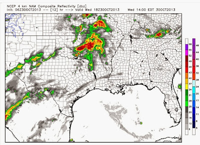
The purpose of this post is to step you through the the next 2 days using simulated radar from a computer model to give you an idea how this will all unfold.  It will NOT be perfect, but it does a descent job!  I still think the main threat will be heavy rainfall and there will be a slight risk for some severe weather over the eastern half of the state.  As I thought yesterday morning, most of the Channel 7 viewing area has been placed under a flash flood watch.  At least 1-3 inches of rain and possibly more can be expected.  The target area is western and southwestern Arkansas, but some of that heavy rain will push into central areas too.  One of the problems with getting that much rainfall this time of the year is the fact the vegetation has gone dormant and it can't absorb as much water efficiently so some of it will go into run off and could produce some flash flooding.  

Straight to the model maps.  I'm going to use maps from weatherbell.com.  I can't say enough good things about this site.  It's subscription based, but in my opinion, well worth it.  They have added so many new things over the past few months and it beats any site out there in my opinion.   I'll have more throughout the event on twitter and facebook.

This is simulated radar valid at 1PM Wednesday.  Again, none of this will be spot on perfect, but it does a good job.  Look at this like you would radar.  This is showing you showers and storms over eastern OK and into western AR.
At 7PM, there are scattered showers, but the worst is still yet to come as the system develops over TX and OK.
By midnight Thursday morning, heavy rain and storms are entering western AR with a few showers across central sections.  Looks like NE Arkansas could have some wet weather too at this time.
By 7AM Thursday, heavy rainfall is falling over central and southwest Arkansas and it's a messy commute.  This is very much in line with where OUR consistent computer models place the heavy rainfall.
By 10AM Thursday, it's still raining heavily! Look at all those reds!  However, there's some good news here. The back edge of it is in western AR.
By 1PM, this model takes the majority of the action into eastern AR and even further into MS and TN.  This is impt and good if this verifies!  This would allow the main action to get out of here before heating can destabilize the atmosphere.  However, the front is still just west so we must watch this.
At 7PM, there could still be a few showers around central sections, but it's nothing major and moving out!!!  Some heavier showers may be over eastern sections of the state at this time.
I love the European model, even in short range situations.  This is doing a good and CONSISTENT job pointing out the heavy rainfall potential from SW into central sections of the state.
The Weather Prediction Center is showing at least 2'' within that green line which includes most of the flash flood watch area.  Southwest AR could see 3-5 inches.  Again, this is CONSISTENT.  That means a lot for forecast confidence.
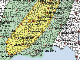
A Flash flood watch is in effect for all the counties in green.
The Storm Prediction Center has placed much of the eastern half of the state including central AR in a slight risk for severe weather.  Remember, the key word here is "SLIGHT".  The main threat will be heavy rainfall.  The main severe weather threats will be high winds and we can never rule out the possibility for an isolated tornado.

Tuesday, October 29, 2013

2 Big Storms Over The Next 7-9 Days


I have no changes to the previous post in regards to the Wednesday/Thursday system.  The primary weather hazard will be heavy rain and therefore flooding will be an issue.  While not in effect at the time I write this post, I expect flash flood watches to be issued for western and southwestern Arkansas.  

The other threat will be severe weather.  This should not be taken lightly even though at this time it doesn't look like an outbreak.  As discussed early yesterday morning, the timing of this system is not favorable for widespread severe weather.  The activity may reach severe limits to our west Wednesday afternoon, but as it pulls into the state Wednesday night into Thursday morning, the instability levels will be lower.  Once we get into the daylight hours, and thus some heating on Thursday, the severe threat will ramp up once again, but the main effect will be near the Mississippi River eastward.  Any changes to the timing of this system could mean more severe weather here, but at this time, the risk is on the low end.  At least a few severe storms will be possible so stay up to date on that!

After reviewing all the latest data Tuesday morning, I still think Halloween morning will be very wet, but there's still a very good chance rain will be out of here by the late afternoon and early evening.

The superior European model handled this situation the best and I'm going to use it again for next week.  We have another system coming in next Tuesday/Wednesday which looks very similar.   Heavy rain will be a threat again and we'll have to watch for the possibility for some severe weather.  Remember, if this next system comes to fruition, the ground will be very saturated from the Halloween storm.  The flooding potential COULD actually be higher.

Remember, when you're looking at these maps, they are not showing you where it is raining at that particular time.  It's showing you how much has already fallen over the previous 6 hours.  This is the European model valid at 1AM Thursday.  This shows you well more than 1'' over western AR from 7PM Wednesday until 1AM Thursday.  You can see the black circle over MN.  That's the surface low with the trailing cold front into eastern KS and OK.  There's deep moisture getting pulled up ahead of that front from the Gulf of Mexico.
From 1AM Thursday to 7AM, the heavy rain is over north central Arkansas to southwestern sections.
From 7AM to 1PM Halloween, there's no way of getting around it... IT'S WET!!!!! Heavy rain will overspread much of the state including the metro.  The severe weather threat is low, but it's still present.  This is mostly torrential rainfall.
Here's at least some good news.  The front is pushing into the state as of 7PM Halloween.  Rainfall from 1PM to 7PM is confined to eastern AR.  You can see the surface low over the Great Lakes with the front extending south of that through IL into central AR.

From 7PM Halloween into 1AM Friday, we're dry according to the Euro!
Now a sneak peak into next week.  This is valid next Wednesday morning.  There's a surface low over northern WI with the front extending south right through IL and into AR.  Heavy rainfall is lining up with it.
The Storm Prediction Center has placed the southeast half of the state in a slight risk for sever weather Thursday.  This includes areas from Texarkana to Little Rock up to Jonesboro eastward.
Check this out.  This is the European model total precipitation over the next 10 days.  According to this 1 model, southwest Arkansas could see 7'' or more.  There's a corridor of heavy rain right into central and northeastern areas where several inches could add up
In summary, we have the potential for 2 rounds of very heavy rainfall over the next 7-9 days.  Storm number one arrives late Wednesday into Thursday morning.  The main threat is heavy rain and the severe weather threat is there, but minimal at this time.  Storm number 2 arrives around the middle of next week.  Since this is in the long range, specifics can't be nailed down at this time.

Monday, October 28, 2013

Halloween Storm


We have got a lot to discuss here as we end October on the stormy side.  First of all, remember the post a couple weeks ago where I looked at the fall so far in terms of temperature?  At that point, October was almost 3 degrees ABOVE average.  After all the cool weather lately, we're now .7 degrees BELOW average.  With that said, temperatures are going to really warm up until we get this storm system out of here on Halloween so there's a good chance we will end this month slightly above.

The one thing I really want to hit hard on this post is the fact we're in our secondary severe weather season and this concerns me.  At this point, the system coming in on Wednesday and Thursday doesn't look like a big severe weather producer, however, that can change.  Many don't realize how dangerous this time of the year can be.  I'll take you back 4 years ago tomorrow (Tuesday).  On October 29th, 2009, several tornadoes tore through south Arkansas.  Leading up to the event, if I remember correctly, the models were advertising this as a high shear, low CAPE environment.  This means there wasn't much instability, but there was plenty of spin available in the atmosphere to create tornadoes if storms were able to tap into it.  But without instability, that can be tough to do.

On the day of the storms, the instability sky rocketed.  The models were incorrect and there was plenty of fuel for these storms to build and spin.  As a result, there were 9 tornadoes that day including one in East Camden which damaged the Fire Training Academy.  You can read more about that day by CLICKING HERE.

I want to make if clear, as of today, I'm not calling for a severe weather outbreak.  Can that change?  Yes.  I just want everyone to be weather aware just in case.  Right now, it looks more like a heavy rain producer.  The timing of this system just isn't all that favorable for severe weather.  The worst of it will come in at night and into the early morning when instability levels are usually at their lowest.  That doesn't mean there can't be severe weather, so let's all watch this carefully.  

As I mentioned, heavy rain will be a real threat and I would not be surprised to see at least 2-3 inches or more in some locations.  As of today, I still think there's a very good chance most of the rain will exit by sunset on Halloween (6:16 PM).  The bulk of the rainfall is scheduled to arrive Wednesday night and Thursday morning.

Remember previous posts where I pointed out the differences between the GFS and the Euro.  I sided with the Euro and I'm glad I did.  When all is said and done, the Euro will have presented a picture that was most realistic.  It's not perfect, but it's doing better than the GFS which is playing catch up with the system.

Below are a few maps explaining what to expect. 

THE MODEL MAPS BELOW ARE FROM A WONDERFUL SITE CALLED WEATHERBELL.COM.  It's a fantastic site and if you're a weather geek, you should check it out.

I'm going to show you a series of maps from the 12Z GFS.  The green blobs show you how much rain has accumulated over the previous 6 hours.  So these maps aren't showing you where it's raining at the time, just how much has already fallen.  You can clearly see the surface low over the OK panhandle.  The black lines are isobars, lines of equal barometric pressure.  Remember,  the flow is counterclockwise into the low.  The tighter the spacing between the black lines, the windier it is.  This is showing you a strong south wind around 1AM Thursday with almost 1'' of rain over the previous 6 hours over western AR and SE OK.
Over the next 6 hours ,1AM to 7AM Thursday, that axis of heavy rain shifts to the east.  The surface low is moving into SE KS.
From 7AM to 1PM Thursday, rain and storms are scooting through the state.  It's a rainy start Thursday.
From 1PM to 7PM Thursday, notice the heaviest of the rain has shifted away.  There's only lingering light showers as the front is in eastern Arkansas here.
From 7PM Thursday to 1AM Friday, it's dry ACCORDING TO THIS MODEL.  This would make Trick-Or-Treaters very happy!!!!
How much rainfall total?  We'll the GFS shows at least 3 inches over western Arkansas and maybe more from southwestern areas of the state into north TX where 6-8 inches could fall there!WOW!  Just a model.
The Storm Prediction Center has placed much of OK and north TX into far western AR in a slight risk for severe weather Wednesday.  The prime time is when instability is the highest.  As the system pushes to the east into the overnight, instability will not be as great.   Remember, this can still change and I'll keep you updated.  The main threat at this time appears to be heavy rain, but strong to severe storms can't be ruled out at this time.

Friday, October 25, 2013

Halloween Forecast... "Trick Or Treat"


The forecast next week is still muddy and I don't expect a clearer picture until this weekend.  It's literally "Trick-Or-Treat".  The European model is the "Trick" and the GFS is the "Treat"

There's little doubt our next significant weather maker next week will produce rain and thunderstorms.  The track, intensity, and timing are all debatable.

This post will be brief as I'm just going to show you what the two main long range models show for Halloween and that alone will show you the forecasting headache I have.  At the bottom is a summary and what I think is more likely to happen.

Here's the European model valid on Halloween at 7PM.  You can clearly see the surface low.  That's the black circle over northern IA and southern MN.  A cold front extends south of that through eastern Kansas into eastern Oklahoma.  All those red and yellow blobs indicate rainfall amounts over the previous 6 hours.  The Euro is definitely wet with at least 1-2 inches of rain during the day on Halloween.  It's much slower with the progression of the storm system when compared to the GFS.
What's a 1000 miles between friends?  That's the difference between the two models.  The GFS valid at the same time shows the surface low over western New York with the trailing front through the middle Atlantic into GA and AL.  It's DRY here.  So this solution is much faster and what all the kiddos (and parents) want.
In summary... what will happen?  Based on previous model performance, I'm going to have to side with the wetter European solution.  At least something closer to that.  It may be a compromise, but when all is said and done, I think we'll look back and say the Euro was much closer.  Why?  Let's go back to the "Race For The Cure" forecast and you can go look at the post.  The GFS was too far to the east with the trough.  It kept it dry while the Euro held on to more troughing west which brought those overnight showers just prior to the race.  The Euro was closer.  While no two situations are the same, the Euro had and usually always has a better track record.  I'll keep you updated and hope the GFS gets it right this time!

Thursday, October 24, 2013

Cabot... March 29th, 1976. Historic Tornado Pictures


I'll have more on the active weather expected next week.  Right now, all the models are all over the place.  Even the Euro is flip flopping.  I still believe there will be significant storm system next week, but its impacts on Arkansas are just not known at this time.  This is typical since it's in the long range still.  I think the water will be less muddy this weekend and we'll see a clearer picture.

This morning when I looked at my email, I received a very interesting message from Meteorologist John Robinson at the National Weather Service Office in North Little Rock.  They are undergoing some remodeling so there's a little "spring cleaning" in fall.

John found some incredible pictures from the Cabot tornado on March 29th, 1976.  This was devastating and made a major impact on that community.  Here's the email I received from John followed by the weather map that day, then the historic pictures.

"In the process of our office remodeling, I came across a series of photos of the Cabot tornado, which occurred on the afternoon of March 29, 1976. (This was the first time I ever got to go look at tornado damage; I'm the last still-employed NWS employee at this office that was here when this tornado occurred.)
The photos were taken from the control tower at Little Rock Air Force Base.
The tornado was rated F3.  It killed five and injured 64."
Here's the surface chart on March 29th, 1976.  You can see a warm front is draped across northern Arkansas with a cold front in OK and TX.  This puts most of the state in the warm and unstable sector of the storm system.
The large trough of low pressure over the western U.S. with a southwesterly wind flow aloft over the mid south is a favorable set up for unsettled weather.  There's a wave of upper level energy located over northern New Mexico and the Texas panhandle.  This kicked out to the northeast and helped initiate thunderstorm development that day.

Wednesday, October 23, 2013

Halloween Week Storm


This will be the first significant storm system of the season and confidence is increasing this will affect the state by the middle of next week.  One thing we must always keep watching this time of year is the severe weather possibility.  While I'm not calling for it at this time, we are in our secondary severe weather season and it's on the table.  There have been years when fall produces more severe weather than spring.  Let's hope this won't be the case.  Right now, it's fairly safe to say there will be the threat for heavy rainfall.

I'm going to follow the more superior European model.  Yesterday, it had one run that was completely out of touch, but I think the overnight run may have a decent handle on it now.  I fully expect temperatures to warm up later this weekend into next week.  Moisture levels will also be on the increase.  This warm up will be short lived as a blast of cold air will move in behind the front.  I would not be surprised to see snow with this dynamic system over portions of the OK/TX panhandle up to Kansas.  Remember, when you're dealing with the long range, it's very tough to get specific.  Just know things are likely to change in terms of strength, timing, etc.

Like I said above, I'm going to follow the European model.  This is valid next Tuesday at 7PM.  The black closed line over WY/CO is an area of high pressure at the surface.  Look at how the black lines drill south into northern and western Texas.  This is the high pushing very cold air (relative to average) south.  The boundary is draped from central Texas into western Arkansas.  In the upper levels, the energy I talked about in the previous blog post is pulling out of the southwestern United States.  The green and yellow blobs are precipitation amounts over the previous 6 hours.  You can see how much with the legend at the bottom.
By Wednesday morning at 7AM (October 30th). The upper low is located over New Mexico/West Texas.  In case you're wondering, that's the red and blue dashed lines making a circle over that area.  That's simply a reflection of the upper low position.  Remember, yesterday's run of the Euro was holding this upper level energy over the Pacific Northwest.  Now, it's pulling it out into the plains and that makes more sense!  The cold front is bisecting the state from PA into northeast Arkansas down into east Texas.  See the greens and yellows?  That's heavy rain surrounding the front.  As the upper level low pulls out of the southwest, you will see a surface low develop along the front.  That surface low will be responsible for more heavy rainfall.   Once it passes, the colder air will really get a push south.
Now we're looking at Wednesday, 7PM.  the surface low is over southeastern Arkansas.  See the black closed line (isobar)?  There's a cold front trailing from that low into LA.  The cold air is pouring into western Arkansas with very heavy rain over much of the state.  Now turn your attention to the upper level low over north TX/OK.  The red dashed line (circle) reflects its presence.  It's labeled "546".  This is a thickness value.  Once it reaches around "540" then we're watching for snow.  This is awfully close.  You must also consider surface temperatures too.  Are they cold enough?  So I think there's a chance for some snow on the north edge of this from the TX/OK panhandle into northern OK and southern KS.  Regardless, underneath the upper low, it's COLD!!!!!!
Now onto Halloween.  This is Thursday at 1PM.  The upper low is right over Arkansas with light rain.  THIS IS COLD!!!! The main front has moved into Alabama.  There's a dry slot from TX into LA up into eastern AR.  The counterclockwise circulation around the upper low is drawing in a dry, southwesterly wind aloft.  Then the upper low moves in and produces a cold rain.  The Euro suggests this could move out by sunset. 
In summary, remember this... IT'S IMPORTANT.  I have shown you above what one model says. IT WILL NOT BE PERFECT THIS FAR OUT!  This will change as far as timing, strength, and track.  But the modeling does agree on a significant storm system next week.  I will likely follow the more superior Euro in this situation.  It blew away the GFS last week when forecasting the Race For The Cure Weather.  I'll keep you updated.  Thanks for reading.  Stay tuned

The NEW Arkansas Weather Blog