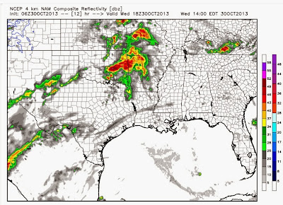
The purpose of this post is to step you through the the next 2 days using simulated radar from a computer model to give you an idea how this will all unfold. It will NOT be perfect, but it does a descent job! I still think the main threat will be heavy rainfall and there will be a slight risk for some severe weather over the eastern half of the state. As I thought yesterday morning, most of the Channel 7 viewing area has been placed under a flash flood watch. At least 1-3 inches of rain and possibly more can be expected. The target area is western and southwestern Arkansas, but some of that heavy rain will push into central areas too. One of the problems with getting that much rainfall this time of the year is the fact the vegetation has gone dormant and it can't absorb as much water efficiently so some of it will go into run off and could produce some flash flooding.
Straight to the model maps. I'm going to use maps from weatherbell.com. I can't say enough good things about this site. It's subscription based, but in my opinion, well worth it. They have added so many new things over the past few months and it beats any site out there in my opinion. I'll have more throughout the event on twitter and facebook.
 |
| At 7PM, there are scattered showers, but the worst is still yet to come as the system develops over TX and OK. |
 |
| By midnight Thursday morning, heavy rain and storms are entering western AR with a few showers across central sections. Looks like NE Arkansas could have some wet weather too at this time. |
 |
| By 7AM Thursday, heavy rainfall is falling over central and southwest Arkansas and it's a messy commute. This is very much in line with where OUR consistent computer models place the heavy rainfall. |
 |
| By 10AM Thursday, it's still raining heavily! Look at all those reds! However, there's some good news here. The back edge of it is in western AR. |
 |
| At 7PM, there could still be a few showers around central sections, but it's nothing major and moving out!!! Some heavier showers may be over eastern sections of the state at this time. |
 |
| I love the European model, even in short range situations. This is doing a good and CONSISTENT job pointing out the heavy rainfall potential from SW into central sections of the state. |
 |
| A Flash flood watch is in effect for all the counties in green. |


No comments:
Post a Comment