I have no changes to the previous post in regards to the Wednesday/Thursday system. The primary weather hazard will be heavy rain and therefore flooding will be an issue. While not in effect at the time I write this post, I expect flash flood watches to be issued for western and southwestern Arkansas.
The other threat will be severe weather. This should not be taken lightly even though at this time it doesn't look like an outbreak. As discussed early yesterday morning, the timing of this system is not favorable for widespread severe weather. The activity may reach severe limits to our west Wednesday afternoon, but as it pulls into the state Wednesday night into Thursday morning, the instability levels will be lower. Once we get into the daylight hours, and thus some heating on Thursday, the severe threat will ramp up once again, but the main effect will be near the Mississippi River eastward. Any changes to the timing of this system could mean more severe weather here, but at this time, the risk is on the low end. At least a few severe storms will be possible so stay up to date on that!
After reviewing all the latest data Tuesday morning, I still think Halloween morning will be very wet, but there's still a very good chance rain will be out of here by the late afternoon and early evening.
The superior European model handled this situation the best and I'm going to use it again for next week. We have another system coming in next Tuesday/Wednesday which looks very similar. Heavy rain will be a threat again and we'll have to watch for the possibility for some severe weather. Remember, if this next system comes to fruition, the ground will be very saturated from the Halloween storm. The flooding potential COULD actually be higher.
 |
| Remember, when you're looking at these maps, they are not showing you where it is raining at that particular time. It's showing you how much has already fallen over the previous 6 hours. This is the European model valid at 1AM Thursday. This shows you well more than 1'' over western AR from 7PM Wednesday until 1AM Thursday. You can see the black circle over MN. That's the surface low with the trailing cold front into eastern KS and OK. There's deep moisture getting pulled up ahead of that front from the Gulf of Mexico. |
 |
| From 1AM Thursday to 7AM, the heavy rain is over north central Arkansas to southwestern sections. |
 |
| From 7AM to 1PM Halloween, there's no way of getting around it... IT'S WET!!!!! Heavy rain will overspread much of the state including the metro. The severe weather threat is low, but it's still present. This is mostly torrential rainfall. |
 |
| Here's at least some good news. The front is pushing into the state as of 7PM Halloween. Rainfall from 1PM to 7PM is confined to eastern AR. You can see the surface low over the Great Lakes with the front extending south of that through IL into central AR. |
|
|
 |
| From 7PM Halloween into 1AM Friday, we're dry according to the Euro! |
 |
| Now a sneak peak into next week. This is valid next Wednesday morning. There's a surface low over northern WI with the front extending south right through IL and into AR. Heavy rainfall is lining up with it. |
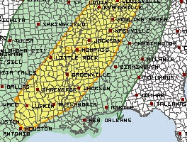 |
| The Storm Prediction Center has placed the southeast half of the state in a slight risk for sever weather Thursday. This includes areas from Texarkana to Little Rock up to Jonesboro eastward. |
 |
| Check this out. This is the European model total precipitation over the next 10 days. According to this 1 model, southwest Arkansas could see 7'' or more. There's a corridor of heavy rain right into central and northeastern areas where several inches could add up |
In summary, we have the potential for 2 rounds of very heavy rainfall over the next 7-9 days. Storm number one arrives late Wednesday into Thursday morning. The main threat is heavy rain and the severe weather threat is there, but minimal at this time. Storm number 2 arrives around the middle of next week. Since this is in the long range, specifics can't be nailed down at this time.


No comments:
Post a Comment