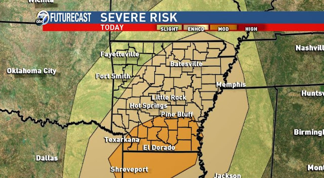
The main threats will be damaging winds and hail. Tornadoes will also be possible. Remember, there are only two things which make a storm severe: hail 1''+ in diameter and/or winds 58mph or greater. Lightning does not make a storm severe, but it's still very dangerous. When the thunder roars, get indoors.
The next system arrives Friday evening with the threat for severe weather and flooding. There could be more than 6'' of rain across northern Arkansas through the weekend which will become a big concern. I expect flash flood watch for much of the northern half of the state this weekend. Severe weather will also be possible for much of the state.
The following maps of future radar is the HRRR from Weatherbell.com. Remember, radar simulation is never perfect.
 |
| 11AM |
 |
| Noon |
 |
| 1pm |
 |
| 2pm |
 |
| 3pm |
 |
| 4pm |
 |
| 5pm |
 |
| 6pm |
 |
| Morning severe weather outlook from the SPC |
 |
 |
 |
 |
| Rainfall through Sunday morning could exceed 6'' across northern Arkansas. I have seen modeling which shows much higher totals possible. Flash flooding and river flooding possible. |


No comments:
Post a Comment