
9:30 PM Tuesday Update... Thanks everyone for a huge, successful, and FUN night on "Arkansas Weather Live". The two main models are now showing roughly 4 inches for Little Rock with higher amounts out west. The only model that counts is "reality" so we'll see what happens Wednesday. It has been brought to my attention that the models are under forecasting snowfall amounts that fell in Kansas today. That will have to be watched for us as the moisture moves into Arkansas. I expect the snow to arrive in central Arkansas around 7 am to 11 am.
I will activate a new post Wednesday that I think you will enjoy. Time for sleep!
12:40 PM Tuesday Update... Nothing has really changed from this morning. The NAM is still the most extreme when it comes to snowfall, but has shifted a little south. The new GFS shows the low end of possible snowfall, but the target from both models are the higher elevations of western Arkansas. The latest Euro puts out .23'' of water which will equate to 4-8'' of dry powdery snow. I posted below a new version of Futurecast and the latest 12Z GFS snowfall.
___________________________________________________________________
We're within 24 hours of the event and there are still MAJOR disagreements between the models with snowfall amounts. The extreme NAM has come down a bit with its outrageous totals and the GFS is steady as she goes with much lower amounts.
I want to highlight the differences between the models and look at how much water each shows..Euro .21'' , GFS .14'', and the NAM is showing an incredible .61'' of water. This huge difference is reflected in the amount of snow produced by each model. Remember though, we are dealing with cold temperatures and very high snow ratios. This means it won't take much water to produce a lot of snow. We're talking about rations around 15:1 to 20:1. This means for every one inch of water, that would equate to 15 inches of snow. This dry, powdery snow will not be good for snowball making, but GREAT for sledding!
The target continues to be western Arkansas no matter what model you look at. I strongly feel the higher elevations in that section of the state will see in excess of 8'' of snow and probably even higher. The further east, the snowfall amounts will decrease.
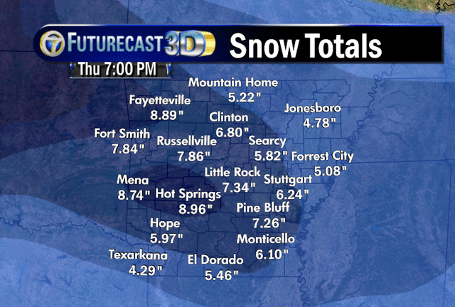
Let's look at some of the models: Using the Cobb method, the 6Z GFS gives Little Rock 2.1'' and the 6Z NAM gives us 8.8''. When I put the models into my bufkit program, the 00Z NAM shows 10'' while the GFS gives us 2.4''
There's no doubt this winter has been snowy as Little Rock now has 8.7 inches of snow and now we're only 4.7 inches away from breaking into the top 10 snowiest years on record. Remember those forecasts for a dry and warm winter due to La Nina? LOL!
I'll throw this out there as well and make a BOLD prediction. I'm really going out on a limb here. At sometime next week, we'll hit 70 degrees. How's that for a BIG turn around.
Don't forget Arkansas Weather Live tonight at 7 PM right here on the blog. Tell your friends and neighbors. If you haven't seen it before, it's all about FUN. It's not the 10 o'clock news for sure! We'll talk about all the possibilities out there and even give away one or two blog t-shirts.
Check out the maps below for accumulation possibilities and timing of the snow. Thanks for reading the Arkansas Weather Blog... We Are Your Ticket To BIG Weather Events!
 |
| 12Z Futurecast |
 |
| 12Z GFS |
 |
| New 12Z NAM which looks realistic with snowfall placement, but still very high on its amounts. It shows a bullseye of high snow totals in the mountains of western and northwestern AR with decreasing amounts further east. |
 |
| Official Channel 7 snow forecast for Wednesday |
 |
| Exclusive and latest version of Futurecast |
 |
| Channel 7's exclusive Futurecast from the 00Z run last night. It's very similar to the 12Z run yesterday, but shows slightly less for northwest Arkansas. |
 |
| 00Z NAM and its extreme scenario |
 |
| The 00Z GFS and its less snowy look |
 |
| This is the NSSL high resolution WRF showing precipitation types at 6 AM Wednesday. I wanted to show this for timing purposes. I don't expect the snow to arrive in central Arkansas until 7-10 AM Wednesday |


18 comments:
This snow event should end up being like the one in january . Little rock close to six inches more as u go southwest. I think we will jump into the top 10 snowiest winters. The number one snowiest winter is at least safe for another year.
So I'm just gonna go with my Gut predicition and say we'll see 8.2 in NLR. Anyone want to challenge me? I'll buy you a burger off the $1 menu at McDonalds if I'm right...
I meant if I'm wrong...geez Tammy...
I'll take that bet Tammy!
I'll give you a free meal at Golden Corral if you are right.
It's funny to me how the GFS and NAM can be so different. One will show 1-2" and the other 6-8" for the same location. I'd like to know which FutureCast map you all feel is most accurate as far as what will likely happen (with us bearing in mind it's only predictions, not statement of fact).
My sweet spot Mena looks good. Hopefully they will get the 13 inches. Just for fun I say Little Rock will see just under 7 "6.8". This snow will be tough to measure with all the blowing snow going around.
Todd, fellow bloggers...
I know this is probably an over simplification, but.. I looked at Earl Barker's wxcaster website. The GFS snowfall and the GFS 10:1 Ratio snowfall maps look very similar. The NAM snowfall and NAM 10:1 Ratio look quite a bit different. Is the GFS not taking into account the possibility of a 15:1 or greater ratio snowfall? Just wondering.....Thanks, Susan
I tend to think we will get 6-8 inches here in Conway. Every local news channel has been predicting this so I go with it. One of channel 7's models is wrong and I think it's the one showing just 2.4! inches
Howdy All!
At least we are GETTING snow and "arguing" on how much! How great is that, normally we would be talking about bust potential.
Btw, Tammy, you are a HIGH roller, lol!
Anyway, I forgot I have somewhere to be tonight from 6 until 10.
Everyone have fun tonight.
Shack
This is the first time I've taken a look at all these models. I'm sure glad I dont have to predict this stuff. Next time you guys say we will get a dusting that turns into 6 inches I will be a bit more understanding lol
How can these models be so different?
I'm going to go out on a limb and say Little Rock will get 7.4 inches, and Hot Springs 8.9 inches. Snowbirdbob, I think Hope will be a good place to go, though it seems like pretty much the whole state of Arkansas is good. Hope it turns out well for you.
Chris aka WeatherChris133344
@monkeypop: I would also like to know how they can be so different. Not that I'm disputing that they are different, I just don't understand how they could be. Perhaps someone who knows way more than I do will chime in and explain...
The models are all so different with the amounts of snow that we will receive. then looking at the the temp.going up so quick and the ground is already soaked, wondering will some areas have flooding problems.I live in the White Hall Area
Sweet deal Ninja! So can this be measured in my backyard or does it have to be at NLR Airport?
Shack, I've never been told that in my life although I've always wanted someone to! Thank you for making my day! :)
What TIME do we expect it to hit Little Rock? I want to wake up to it, not fight my way home in it with a bunch of freaking idiots on the interstate.
LMBO Tammy, too funny, glad to do it!
2" or 8", I'll take it. Too bad some of those earlier NAM's didn't hold on, I would have loved to have had close to blizzard conditions. Maybe when it gets closer it will start sucking up more moisture and dump on us. What was the forecast for that storm a year ago? Didn't that one surprise us? I thought someone mentioned that anyway.
Everyone stay safe and off the dang roads!
Shack
P.S. Todd, maybe you will finally get some sleep this weekend after our 3rd and final storm gets done.
Just FYI, if Futurecast verifies I will proudly take my weatherblog t-shirt for the winter weather contest. I bet you guys thought 51.6" was foolish (and every other year you would be right). Sitting at 32" right now, I need 19.6" combined from Harrison, NLR, LR and PB. Bring it!!!!
The roughest answer I have found about the various models being different by searching on the Internet was the following statement: differences in how the math is set up and the amount / quality of the weather data ingested into the model accounts for the differences in the models. In other words, it comes down to what readings they get off weather ballons and other monitoring stations and how the computer software crunches the numbers. All of them use different equations and all work different for different regions. So they are never going to be perfect. Just a best guess based on what facts are known.
Post a Comment