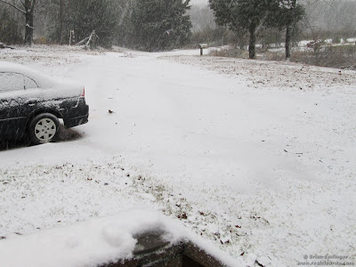
We told you to hold on tight last Saturday for another wild ride! I think this storm system has lived up to its expectations. The rain generally amounted from 3 to 6'' area wide and lasted for about a day and a half. The cold temperatures didn't make it feel any better. The one thing that I wish I hit harder on the forecast was the snow in northwest Arkansas this morning. Amounts were small in the lower elevations, but went up to about 3'' on some of the higher mountains in the Ozarks. While I thought there would be a wintry mix for the northwest, it was a bit further south than I anticipated and the amounts were higher than I thought. I don't hear many complaints. There's nothing like a good snow to put you in the Holiday spirit. The winter weather contest is in full swing and we should have some small amounts for Harrison when the official data is released later Monday.
The curveball I talked about in the post below for Wednesday is still there. An upper level low will move across the area Wednesday and should bring a few clouds. It's not out of the question to get a sprinkle, flurry, or a sleet pellet. The chance is very low though as the models are not showing much if any precipitation with it.
Back to the rainfall, amounts lately have been incredible and I thought it would be a good idea to put out a few interesting numbers.
- In Little Rock since Saturday night, we have had 5.06''
- In North Little Rock, the total is 4.86''
- The rainfall surplus in Little Rock this year is 11.86''
- In North Little Rock, the surplus this year is 13.92''
- It's now the 4th wettest year in North Little Rock weather history which dates back to the 1970s.
- Little Rock established a new daily rainfall record Monday with 2.06'' shattering the old record of 1.92'' set in 1936 (75 years)
- Little Rock established a new daily rainfall record Sunday with 3.00'' of rain shattering the old record of 1.54'' set in 2002
- 34% of our yearly rainfall in Little Rock has fallen in November and the first 5 days of December.
- 28% of North Little Rock's rainfall this year has fallen in November and the first 5 days of December.
Here are a few pictures sent in from viewers of the weather across Arkansas over the past couple days. Remember, you can always send yours to photo@katv.com
Remember to stay connected on facebook: Todd Yakoubian
and twitter @katv_weather
 | |
| Snow northeast of Ozark at 1600 feet. Thanks to Brian Emfinger. www.realclearwx.com |
 |
| Another picture from Brian Emfinger. He says up to 3'' fell here |
 |
| Beautiful scene near Jasper |
 |
| Kids get their first taste of snow in Harrison this season |
 |
| Nice scenery in Hatsy, Arkansas |
 |
| Flooded just east of Conway |


5 comments:
Todd u always downplay the snow. Last week it was northeast ark and this time northwest. Maybe one day uou will hit it just right.
Anymore chances for snow for northern and central arkansas in the next 10 days?
Well my Dec 5-10 Coldest air of the season was a hit. Fayetteville forecast low tonight is 14! Alot of N Arkansas may not make it out of the 30's the next couple days too. The first Winter storm on the other hand didnt pan out so well, even though we did see a "few" WW Advisories.
My next wishcaster dates for COLD and Winter Weather are Dec 18-21. Could be some warmer weather next week 16-17 with storms???
Jason Wishcaster Hampton
Good Call Jason...From the SnowBird
Well, I guess I'll go out of town more often, apparently you will get 2" of snow in LR. DANG IT!
Shack
Post a Comment