I got a lot of that on social media Sunday. Tornadoes and severe thunderstorms in December? Why is this happening? Well, this is actually very typical. We are currently in the heart of our secondary severe weather season and having this happen isn't unusual at all. Remember my post about the 30 year anniversary of the December 1982 tornado outbreak? There was another major outbreak later that month on Christmas Eve.
In previous blog posts, I mentioned the transition from the mild to cold weather could become a bumpy ride. Just as the warm and cold air compete in the spring, the same can happen this time of year. Will there be more? I say there's a better chance than not we'll have more severe weather before springtime officially arrives. I hope I'm wrong.
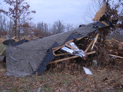
Meteorologist John Robinson with the National Weather Service office in North Little Rock surveyed damage in Fulton county near Viola. He determined it was NOT a tornado, but a strong thunderstorm downburst that caused a roof to blow off a duplex. 1 person was injured as winds reached 70-80 mph. This just shows you how severe thunderstorm warnings need to be taken seriously too. I have not heard from the National Weather Service office in Memphis on any surveys in their northeastern Arkansas counties. I'll keep you updated.
Here's information and pictures from the NWS survey in Fulton county. Thanks to John Robinson for the pictures.
 |
| Roof blown off the building |
 |
| The roof was blown into a nearby field. Looks like a dusting of snow on the ground, but that's probably insulation. |
 |
| Amazing how severe thunderstorm damage can be just as bad as a weak tornado |
 |
| Portions of the destroyed roof. |
 |
...NWS DAMAGE SURVEY FOR 12/9/12 THUNDERSTORM WIND EVENT

.REFERENCE THUNDERSTORM WIND 1...

PEAK WIND /ESTIMATED:70-80 MPH
PATH LENGTH /STATUTE/:1.1 MILES
PATH WIDTH /MAXIMUM/:60 YARDS
FATALITIES:             0
INJURIES:1

START DATE:DECEMBER 9...2012
START TIME:12:55 PM CST
START LOCATION:5.1 W VIOLA /FULTON COUNTY/ AR
START LAT/LON:36.3930 / -92.0739

END DATE:DECEMBER 9...2012
END TIME:12:58 PM CST
END LOCATION:4 W VIOLA /FULTON COUNTY/ AR
END LAT/LON:36.3978 / -92.0542

SURVEY SUMMARY: NATIONAL WEATHER SERVICE METEOROLOGISTS SURVEYED
THUNDERSTORM WIND DAMAGE...OTHERWISE KNOWN AS A DOWNBURST...THAT
OCCURRED WEST OF VIOLA ARKANSAS. THE DAMAGE WAS CONCENTRATED TO
AN AREA ABOUT 60 YARDS WIDE. MAXIMUM DOWNBURST WINDS...BASED ON
VARIOUS BUILDING AND BARN DAMAGE...WAS ESTIMATED BETWEEN 70 AND
80 MPH. THERE WAS MAJOR DAMAGE TO 3 MOBILE HOMES...ONE DUPLEX...
3 BARNS...AND 4 OUTBUILDINGS. THE WORST DAMAGE OCCURRED TO A
DUPLEX WHICH HAD THE ROOF TORN OFF. THE DUPLEX WAS LOCATED ON TOP
OF A HILL AND IT APPEARED THAT THE WIND GOT UNDERNEATH THE ROOF
OVERHANG AND LIFTED IT OFF. THREE FAMILIES WERE DISPLACED BUT ARE
STAYING ELSEWHERE WITH FAMILY MEMBERS. THERE WAS ONE MINOR INJURY.

NOTE: THE INFORMATION IN THIS STATEMENT IS PRELIMINARY AND SUBJECT
TO CHANGE PENDING FINAL REVIEW OF THE EVENT AND PUBLICATION IN NWS
STORM DATA.


1 comment:
Actually that is a dusting of snow.
Post a Comment