

TWITTER: KATV_WEATHER
As you know here on the Arkansas Weather Blog, this is a place where I discuss my thoughts about individual storms, upcoming weather patterns, etc. If you have been reading over the past several days, there's a strong upper level feature coming out of the southwestern United States that has raised concerns with me. Several of the computer model runs last week indicated a heavy swath of snow through the state Wednesday night and into Thursday. Even the NAM (which has been horrible this winter), showed it up until 2 days ago! Now, every single piece of data out there says it will come through DRY! NO PRECIPITATION! You know how we learn from history never to make the same mistake twice? I'll be honest with you. Before coming home to Little Rock, I was forecasting in Chattanooga, TN and got burned by one of these systems. I'll never forget what another meteorologist said, "Those vort maxes will get you every single time." Fast forward to December of 2011. Just two weeks prior to Christmas we had a strong upper level low approach from the west. Not one piece of data showed any precipitation with it! We ended up with 2 inches of snow. Although, that system was further north than the one we're dealing with late today. As I have said, I'm not writing it off. Chances are this won't do much of anything, but let's watch it today!
In other weather news, it looks like we will warm our temperatures a little late this week and into the weekend, then another shot of cold air arrives taking our temperatures below average again. This looks to be in and out. We could see another period of above average temperatures, then another piece of cold air comes down even further down the road. Anybody want to trade this winter in for last winter? I don't! LOL. The challenge forecasting this stuff is what I live for!
 |
| This is the 06Z GFS valid Thursday morning at 6AM. See those blue dashed lines in a circle over SE Arkansas? That's a reflection of the upper level system. This is generating very light snowfall over the far southeast corner of the state. But the rest of the state is dry. |
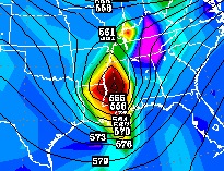 |
| This is a look at the storm at the 500 mb level. That's quite strong and that has me keeping an eye on it. The track is further south than the Dec. 2011 system if memory serves me correctly. |
 |
| HPC winter forecast products do indicate a chance for accumulating snow, but it's east of the state. |
 | |||
Now check out this hi res model indicating very light amounts of precipitation from El Dorado to Pine Bluff over to West Memphis south and eastward. This is just a computer, but you see the concern! In summary, while all the data shows not much of anything late today into Thursday morning, let's just watch it. Chances are right now it won't produce much and maybe nothing. We'll get a break from the cold for a couple of days, then it's back to some colder weather next week. Any moisture next week? Tough to say right now, but the flow looks northwesterly which is fairly dry! Sometimes you can get clipper disturbances coming through, but those usually only produce snow flurries and are usually directed north and east of the state. I'll keep you updated. |


1 comment:
It looks like this "arctic air" isn't going to be so strong after all, according to Ninja's new post. What a disappointment.
Post a Comment