AND ON TWITTER: @KATV_WEATHER
First, off the top of this post, I'm very sorry for not updating the blog lately. As you know, I started this blog about 7 years ago on my own because of my extreme passion for Arkansas Weather. Summer is usually a quiet time of year, and with a family, I have been spending a ton of time with them. I guess I have two passions now! Blake and Preston are a ton of fun. It's such a tremendous joy showing them new and exciting things and watching the expressions on their face. Some of the simplest things in life can make a 3 year old smile from ear to ear. For example, I took Blake out to Ferndale to pick blueberries a couple weeks ago. Holding a bucket in his hand, he sprinted to those blueberries and could have picked them all day long if I let him. I also took the boys out to Cabot earlier this summer to pick strawberries. We were walking up a row of plants and after a few seconds I was wondering where Preston went. I turned around and found he couldn't wait to get home and eat them.
 |
| Top photo is Preston eating those strawberries right off the plant. The bottom left are my boys in Cabot posing for a picture getting ready to fill that bucket behind them. The bottom right is Blake picking blueberries. Nothing like fresh Arkansas fruit in the summertime!!! |
Now onto the weather. There is NO doubt this has been a different summer compared to the past 3. I know many of you use the summer of 1980 to compare this hot time of year to. It has been nothing like that horrible stretch of triple digit heat.
Let's take a look back at each month this year. Every month has been at or below average EXCEPT 2 of them. Take a look. You can click to enlarge
The pattern over the next several days will feature a northwesterly flow aloft. This time of year, it brings clusters of rain and storms. The area of the state which will be most prone to this beneficial rain is the northern half where many of the current "burn bans" are in effect
 |
| This is the upper level pattern by the middle of the week. This true northwesterly wind flow is produced by high pressure over the western United States and a strong trough of low pressure over the Great Lakes into Canada. The flow between these two features will send a series of upper level impulses from northwest to southeast. With plenty of heat and humidity in place, look for areas of rain and storms through much of Monday, Tuesday, and Wednesday. |
 |
| The manual progs from the Weather Prediction Center really shows the potential for drought busting rains. IF THIS VERIFIES, MORE THAN 4 INCHES COULD FALL OVER THE NEXT 5 DAYS ACROSS MUCH OF NORTHERN ARKANSAS!!!!! This is where the track of the disturbances are more likely to produce copious amounts of rainfall. Sometimes, too much at once can be a bad thing. We'll have to watch for flooding unfortunately. |
 |
| The 8-14 day outlook, going into August, shows a good chance temperatures stay below average! |
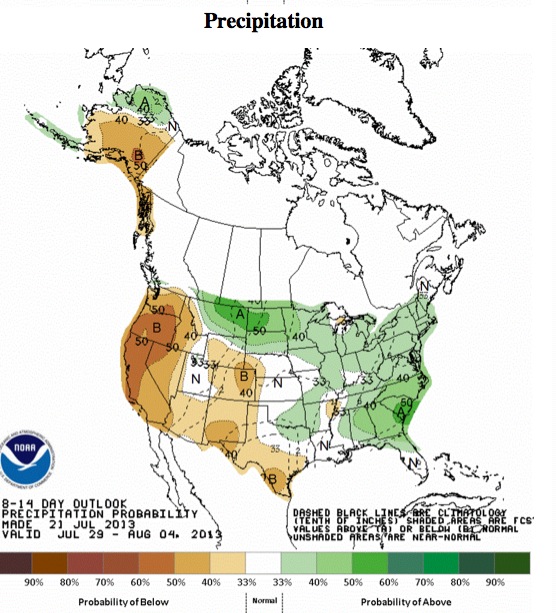
 |
| And there's a good chance we'll see some precipitation as well!!! |


No comments:
Post a Comment